You’re Late!

The Arctic Triple 100 mile ultra trail in Lofoten, Norway. An event I eagerly looked forward to but one for which my preparation was screwed before I even signed up. Back in 2022 I’d already signed up to Transylvania 100 and Mozart 100 for 2023. When Matt floated the idea for this race in Norway, and him and Paul signed up, I was torn. It ticked every box on our criteria for an adventure. Trouble was, it was a week after Transylvania (we’d actually start 4.5 days after the finish time of Transylvania!) and two weeks before Mozart. This was not an ideal time to squeeze a 100 mile event into my year. But I did, of course I did! I signed up. My plan was simply to survive and enjoy Transylvania without wrecking myself before Lofoten. That didn’t quite go to plan and the race in Romania was far harder and more damaging to my body than I’d hoped for. Come Monday, I could barely walk. Besides bruising to my right quad, my feet were in pieces. They were so sore and covered in blisters. It was 3 days of soaking them in salt water, applying creams and ointments and hoping for miracles.

By Thursday, miracles had happened. Somehow my feet had healed pretty well, well enough that I wasn’t in any discomfort, maybe still missing a few important layers of skin, but after a self inflicted stressful few days I was confident again. All that was left was the day-long journey to Svolvaer where the race headquarters and finish line was based. That night, I wrapped my feet as best I could in hypercolloid dressings and KT tape. I hoped this would buy me a bit more time during the race before further damage was suffered. I also opted to wear waterproof socks to start the race (which turned out to be the best decision I’d made that week!).

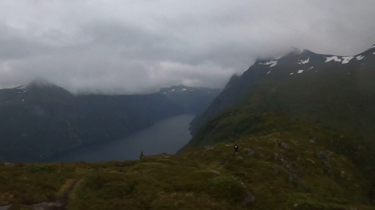
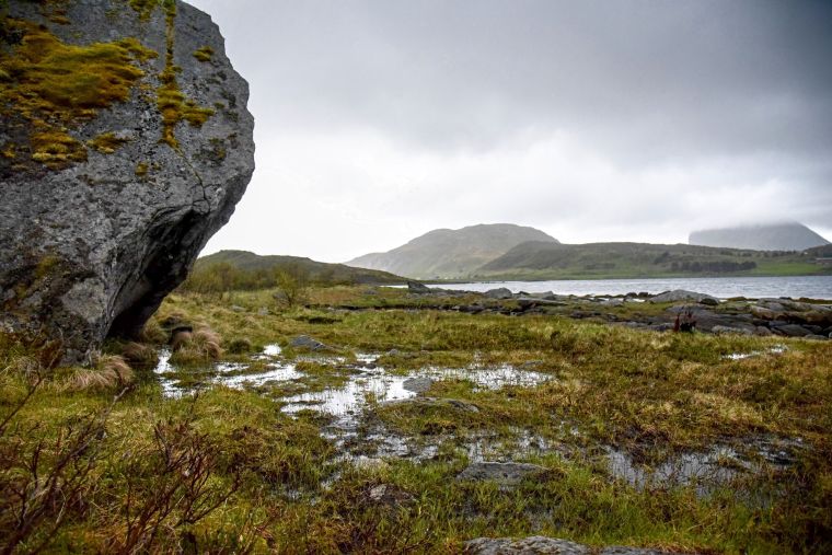
The next day the journey to the start line began, this was like an ultra in itself – it involved a 2 hour bus from Svolvaer to Reine and then a 30 minute boat ride to Kirkefjord. The bus journey to Reine was scenic and gave a good first insight into the stunning scenery and terrain of the peninsula. We drove around the islands and mountains making up the landscape and crossed bridges and went through tunnels that connected all the islands. The mountains were quite a sight and dominate the skyline.

Suited and booted for the boat ride

At Reine we left the bus to get a boat across the fjord to Kirkefjord where the race would start. Due to some logistical issues, the planned ferry boat wasn’t available, therefore smaller boats would complete the transfer. This worked out amazingly for us as we were stopped before boarding the boat that was waiting when our bus arrived as it was full. Instead we were directed to a smaller speed boat/dingy. This meant donning a life/body suit. I made sure we were first in line to get suited and booted. This boat looked so much fun! Straddling the seats we held on as the boat sped off. Wow. What a way to start a race and what an experience bouncing along the water, the wind and rain battering our faces. The attempts to disembark were then hilarious as we tried to climb up the jetty and needed pulling up from the marshals directing us in.

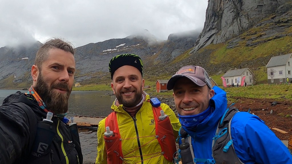
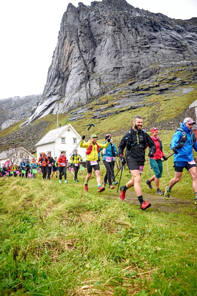
We had about 45 mins before the start and spent it sitting in a wood cabin on the ‘pier’ to take shelter from the rain and exploring a vacant building. At midday, as we made our way to the start line, we found ourselves at the front of the runners. This made us giggle as we did not belong there, but we embraced it as we set off, momentarily leading the other 70 or so runners into the adventure that awaited…

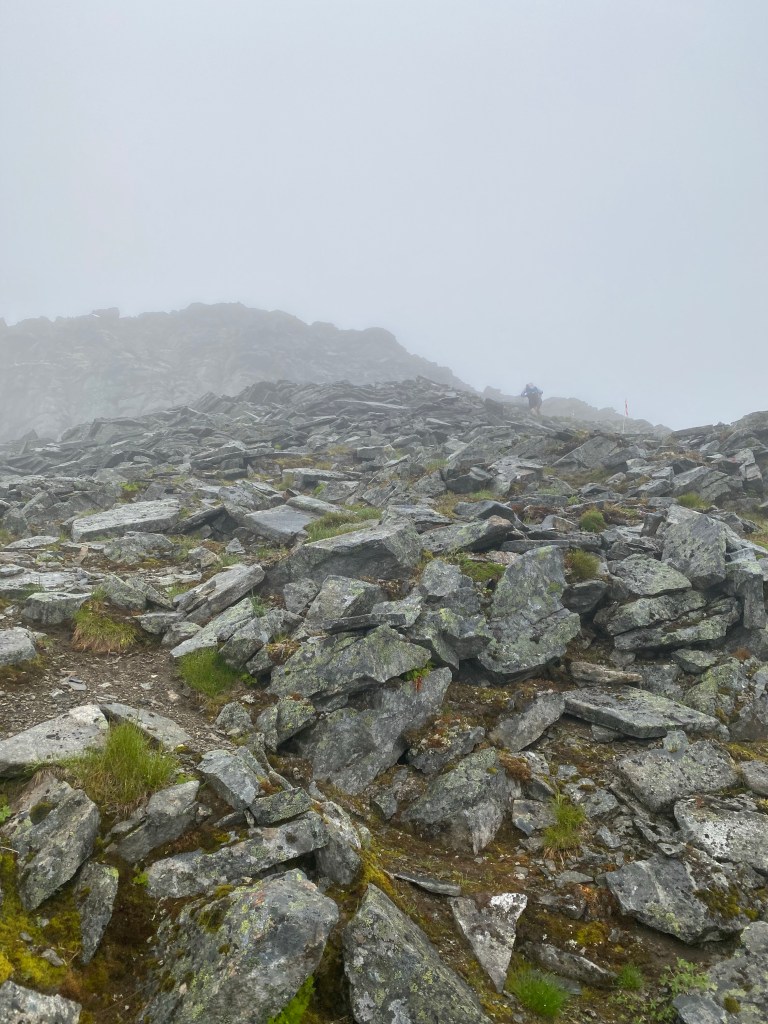
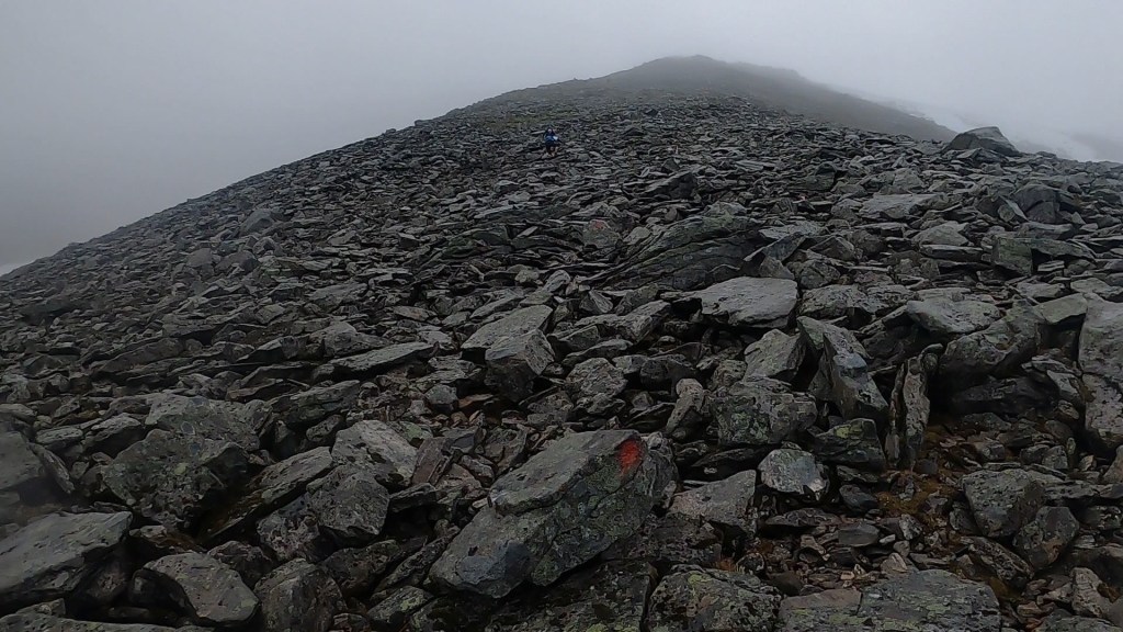
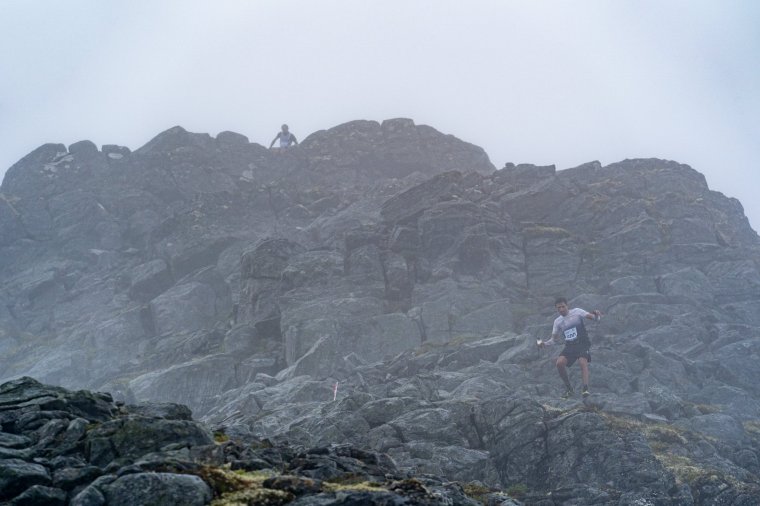
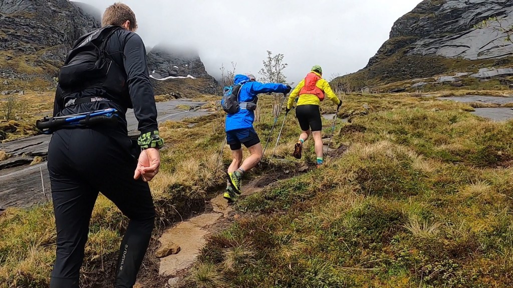
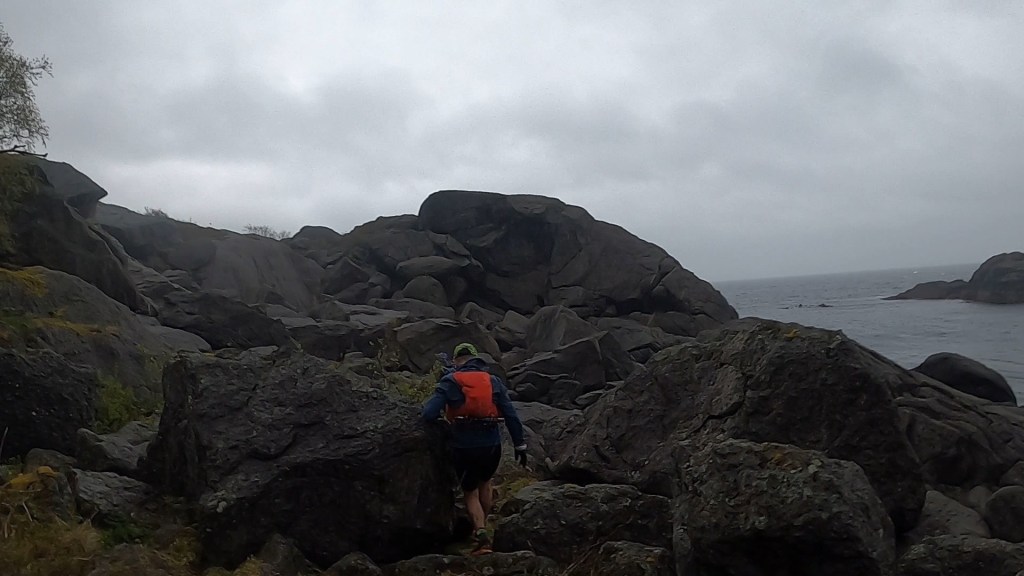
The race starts with two steep climbs. The first about 100m and the second a bit more punchy at around 350m. Straight away I was huffing and puffing. The terrain was mountainous, rocky and wet with water streaming down the slopes. The incline was sharp and the gradient reached a good 30 degrees in places. Runners inevitably started passing us as we climbed. As we reached the top the of the first climb the fun began. Groups of runners started passing us at speed as we tried to navigate the slippery, rocky terrain. In some parts small remnants of snow made the rocks extra slippery. I wasn’t ready for more snow after last weeks fun in Romania. I was making my way tentatively.

Leading the way. Bunch of clowns

I cautiously crossed the trails connecting down to the second, steeper climb. I fell a few times along the way, slipping off the large boulders we had to traverse. As we began climbing again the story repeated itself. After reaching the top another tranche of runners went passed. We were now near the back of the field already. We’d barely been running an hour and already couldn’t keep pace with everyone!

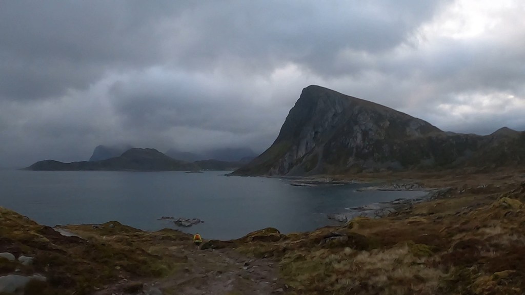
The race description and briefing did indicate that the first 20km or so made up some of the harder sections of the race, so we weren’t disheartened just yet (even if we were only about 6km in!). Besides, from here we began the route towards the beach at Kvalvika as we descended again. We had a short road section and the first checkpoint with refreshments before we were heading off track again towards the beach with a short climb and descent along the way. Here we started to be caught by some of the relay runners who started after us. You can also cover the 100 miles in a team of up to ten people. In 2024 they are also offering the 100 mile event as a multi day adventure. The views, despite the wind and rain were incredibly pleasing on the eye. We knew about this beach after watching the short film ‘Nordfor Sola’. It’s about two young men who embark on an adventure and spend 9 months living on the remote beach, building a ‘cabin’ out of materials that wash up on the shore and that they salvage.

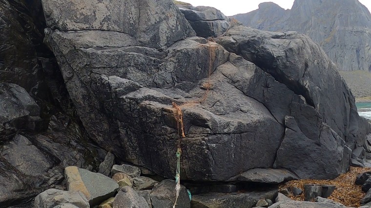
The beach is split into two sandy bays. As we reached the first, the trails took us right to the coast. By now Matt had fallen numerous times, the last one spraining his wrist. He was in pain, but masked the pain with his excitement of reaching the beach. The descent to the beach itself was very challenging. We clambered over large boulders and loose rocks, lowered ourselves down cracks and used ropes and chains to reach the beach. It took a little navigating for us to find our way down and the rope descent was tough going, even if it wasn’t very high! We immediately then had to climb and clamber back up and over the wet rocks to work our way around the coast.

The ropes and boulders connecting the beaches made for slow going

Eventually we reached the second beach. The one made famous from the film. In the distance we thought we could see the the makeshift chimney from the cabin. A surfer was preparing himself for a dip in the vast Atlantic ocean as we began the long, wet climb away from the beach. Again, barely a 200m climb, but the incline was steep and the soggy wet ground made for slow going. This would be the theme for the climbs in the course. None were particularly long or high. But they were steep and always sapped the energy and reduced us to a snails pace. At the top a Photographer waited patiently and snapped the runners as we made our way onto the boardwalk planks installed over the boggy ground. They kept our wet feet from getting even wetter. The solid ground was greatly appreciated. The descend took us back along some gravel tracks and boggy downhills towards the next checkpoint, 20km in at Fredvang. We stopped for a short rest here having some warm soup and plenty of the ‘Triple Buns’ (kind of like a fruit loaf bun) which were excellent. We studied the route for the next section and made some mental notes of the runners around us. We were conscious that there was a new cut off (noted during the race briefing) at the 56km mark at Napp. We had 14 hours to get there but had already taken 5 hours to cover the 20km to this point. It didn’t make for good thinking, but we held on to the belief that the trails would soon get ‘easier’ and we’d reclaim a little time.

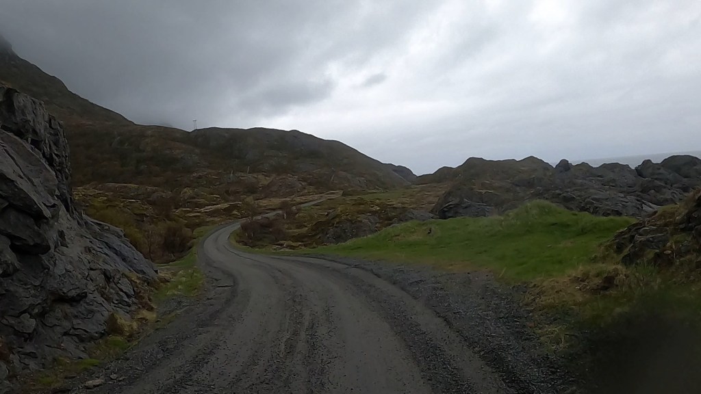
Leaving the Check point we carried on for a few kms along the road, crossing two bridges connecting the islands. There would be plenty of bridges along the course and these first two gave the initial impression, with steep inclines and descents either side (the steep shape allows for the passage of boats underneath!).

The roads then gave way to gravel tracks and, as we neared the southern edge of the island, we were back into the boggy marshland and forests near the coast. The wind and rain was continually battering us and we found this section particularly cold with the head-on wind. The coastal section was tough going and we were all over the place trying to follow other runners and navigate our own way through the bogs, sometimes slipping knee deep in the stinky mud. I was so thankful for the waterproof socks at this stage!

Professional photographer’s image of some of the wetter terrain and bogs

We were very wet now with the heavy rain pelting us from all angles and the ground soaking us from below with every step along the spongy ground. It took us about an hour and a half to cover the 7 or so kms here and emerge back onto some beautiful coastal roads making our way to the next checkpoint at the picturesque fishing village of Nusfjord. We rounded the buildings and into the shelter of the checkpoint.

The checkpoint was outside but we made good use of the shelter with heaters and blankets. We could feel the icy wind blowing from the sea so tried not to spend too long tending to our needs. Somewhere in these opening kms I’d noticed my eyesight was a little bit hazy. I’d covered up my left eye and realised everything through my right eye was blurry. It occupied my mind for a while as I’d had something similar back in January when running the Tea Round in the lake district. By the end of the run I’d lost eyesight in my right eye. It came back when I woke the next day and I put it down to a bit of mild snow blindness after running for 13hrs in the snow. I’d made a note to myself to keep being aware of it as I’d a lot longer to run this time and it clearly wasn’t related to snow! We stocked up and refilled on more triple buns, emptied our shoes of excess sediment from the bogs and warmed our hands under the hot water tap. 8 hours and 40km covered, we’d reclaimed a little time and were confident of the impending cut off at Napp. Which was good, because the next section to Napp was said to be particularly challenging and we were warned by he Race Director during the race briefing not to be deceived by the relatively flat route profile for this section. We continued to hold on to that belief that, if we got through this next section, things would become little bit easier. We just set our sights on Napp 19km away and headed off towards our target…

One of the professional photographer’s captured this incredible view of Nusfjord fishing village

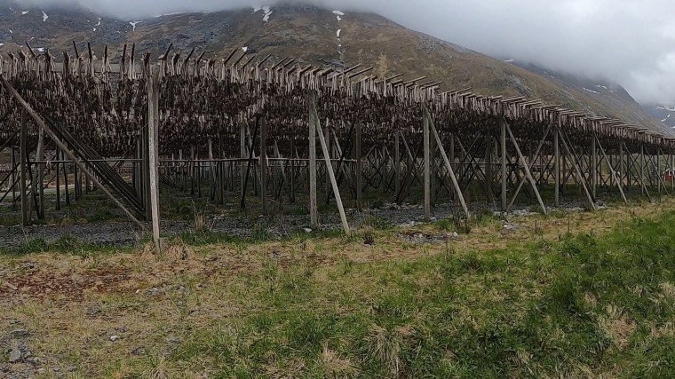
By now it was night time. Night time was a little different here as we were inside the Arctic Circle. During these months of the year, the area receives 24 hour daylight. Not having the changing atmosphere as darkness set in was certainly an unusual experience for us. Hopefully it would mean our tiredness would also be kept at bay and the daylight would help keep us awake – we were tired with the long day of travel, early start and effort of the first 40km. Anything that would keep us moving forward would be welcomed. The road out of Nusfjord continued for a few km, we passed some drying fish (we’d learnt about the fishing industry and exports of dried fish heads to countries like Nigeria from some local runners on the bus ride out) before we headed into the forests and started climbing.

Fishing villages were covered in these fish drying stands

It started with a slow and steady climb on loose scree. We jokingly (seriously) hoped this was the ‘technical’ element. Of course it wouldn’t be. We climbed further and the visibility got less and less as we entered the mist. We barely climbed 150m before we began descending on more of the same terrain with a well defined path and limited visibility. Inevitability more marsh and bogs lay in wait as we left the path and head off track with several more smaller climbs and descents to cover as we made our way back towards the coast.

Climbing into the mist just outside of Nusfjord

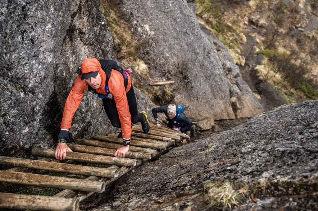
Once we reached the coastline it was a particularly treacherous coastal section. I just recall boulder after boulder putting further stress on our tiring legs. More ‘light’ scrambling and scaling waterfalls (frustratingly my GoPro battery was playing up here so I’ve no visual records of this whole section, the professional photographer photos however capture a little of this brutal terrain!). It was beautiful and surreal but arduous at the same time. I don’t think I’d imagined that I’d spend so much time on his race on all fours in the water trying to haul my ass upwards. It was very slow going. The weather didn’t relent and we were cold and frustrated. I had three pairs of gloves on and had started ripping the waterproof over-gloves from all the climbing on jagged rocks. After what felt like a lifetime of navigating the coast we found ourselves upon the ‘small’ ladder mentioned in the briefing (mentioned as a safety notice as the bottom was a little broken), but it wasn’t quite what I’d envisaged. It looked huge to me. Not long, just oversized. Like it was made for some Nordic God. Down we went, my hands barely able to wrap around the rungs of the ladder and hopping to safe ground near the bottom. From here the theme continued as we descended further, still battered by the wind and rain. We had now resorted to sitting on our bums to lowered ourselves through cracks and gullies. My waterproof over mittens were now ripped and a hole torn open. I questioned why I buy myself nice kit and then do these events and break everything!

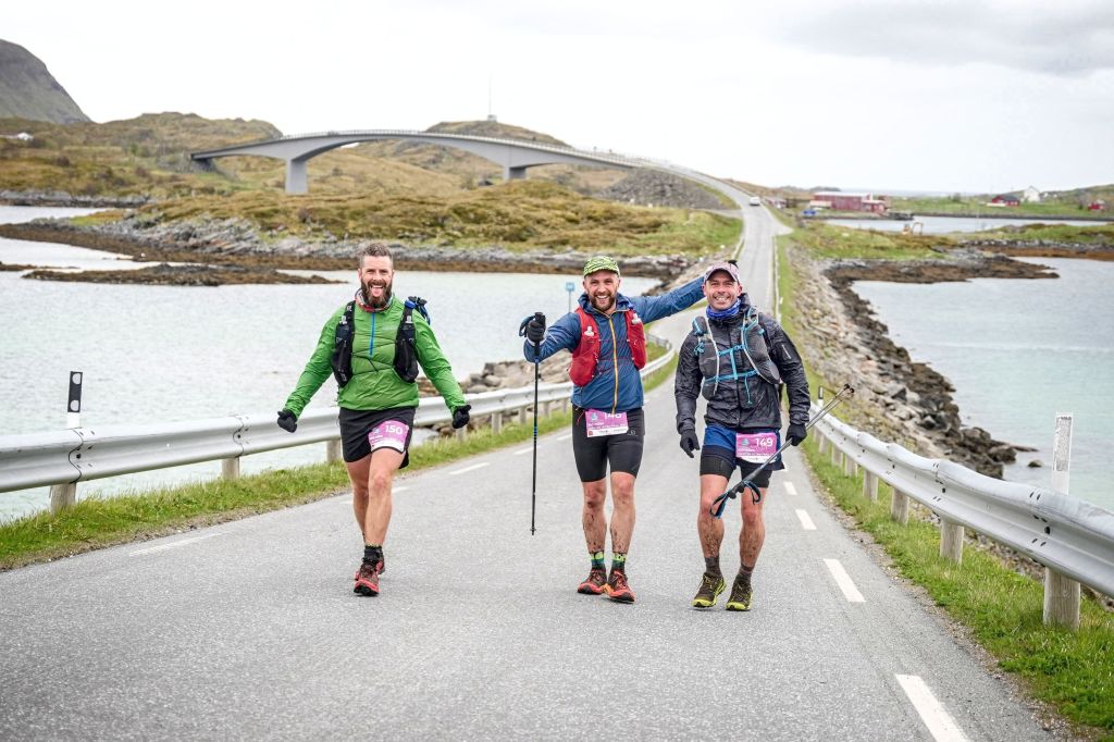
It probably wasn’t as bad as I remember, but it did take us a long time. Looking back it took us about 2 and a half hours to cover 10km along this coast. We had a few small navigation errors as we tried to keep the pink flag markers in sight. I can’t recall how, but it eventually came to an end. Somehow we came out into the village of Napp, ran along the road and found the school where the next checkpoint was. We were relieved, we’d been going for about 12 and a half hours now and were very much in need of a rest. Thankfully Napp was where our first drop bag could be retrieved and we had time. We took about an hour here sorting ourselves out. As we started changing our clothes a thoughtful volunteer started mopping up the water that we were leaking. It was everywhere. She also appeared with a bucket when Matt had a coughing fit. He had to reassure her he was ok. We’d planned this stop ahead and all had plenty of warm, and spare kit to change into. With warm kit on and more soup and triple buns consumed, I set about ‘preparing’ my feet for the next section. I was surprised that they had held up so well. Compared to the others, my feet looked great and in far better shape. The waterproof socks had worked wonders. I cleaned them up and dried them off, applied fresh compeed and taped over my soles, heels and little toes. A fresh pair of socks (more waterproof ones!) and dry shoes finished off the pitstop. I wasn’t making the same mistakes I’d made last week in Romania and was super confident that I was managing my body better.

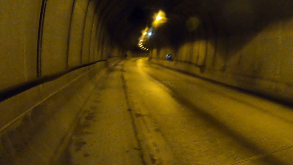
After a good dry out and reorganisation we set off. We even had toasty fingers after warming our gloves a little on a radiator (spare dry gloves would be the one addition I would have made to my drop bags in hindsight!)! From Napp it was a short road section before a 2km stretch through an underground tunnel. By now it was about 2am (so confusing with the day light!) so there was minimal traffic in the tunnel. A lorry did pass us as we were ascending out of it and and the roar and echo was deafening. Being on flat ground, I ran this section with my Buff covering my right eye to try and ‘rest it’ a little bit and hopefully give the eyesight a chance to recover. I looked like a right Pratt.

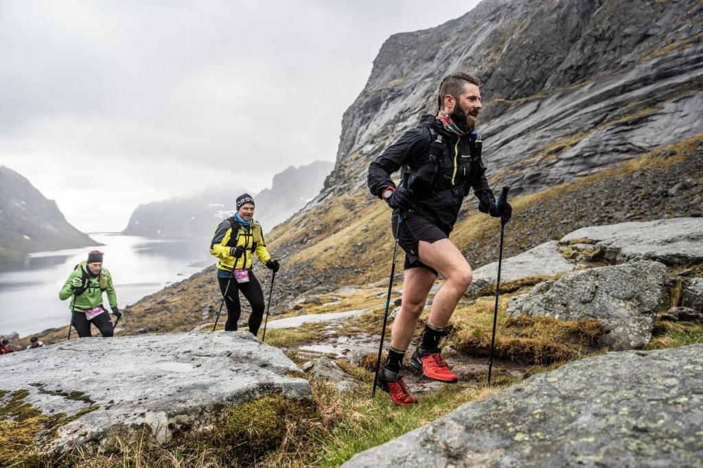
Emerging from the tunnel we looped back on ourselves for a circumnavigation of a big ol’rock – the mountain Offersøykammen. It stood there prominently for the whole section as we ran around it. It started with gentle trails which soon became became wetter and rockier. Before we knew it we were back on boulders, scrambling along the coastline and deviating onto wetter sections where safer (we heard the following day that a runner fell and broke their ribs along this rocky section, we don’t know if that was substantiated or not though). There were a group of runners here. We talked a little bit acknowledging the difficulty of the course and conditions. As the race description says ‘this section is hardly any trail and more technical following the rocky coastline’. It was nothing but accurate! The trail looped us out onto the road which we’d now follow on a diverted course – due to local land restrictions this year, we’d avoid another coastal section to the north and instead loop south to Leknes and Brustranda before re-joining the original route further along the E10 road. We ran through Offersøy and continued on the road to Leknes.

The group of us jogged on in our own paces. Interchanging leaders and varying progress along the road. We felt we put a pretty solid shift in and ran consistently here with short walking breaks as the road inclined. We were aware that these long road sections, as tiring as they were, would be our only chance to gain some ground in a race against the clock. We made good progress, although we could all feel that fatigue was beginning to set in. We’d been up most of the night and the benefits of constant daylight was starting to wane as it was now passed 04:30 in the morning. After hitting the cross roads at Leknes it was a straight line to the checkpoint at the hotel. We entered and the first thing that struck us was that it was so warm. It was great. The smell of warm food filled the room. We discussed having a power nap so found a table and put our heads straight to rest with a timer set for 10 minutes. We needed a recharge. As we woke we went in for the food. There was a sausage (single!) and some wraps that we shared. We tucked in and, at 30 mins, probably stayed a little longer than we should have but we were ready to go again and very much needed to close our eyes for a short while. Most of the same runners who’d arrived before or after us were still here too, so we weren’t overly concerned as we braved the cold once more.

I loved this view on a coastal road. It was a earlier in the race and a long time before we reached Leknes

The next section was about 17km and mostly road as we followed the diverted course to Brustranda. Almost immediately my feet started to hurt. I was a little frustrated as they’d felt so good up until now and we were only half way through the race. I’m not sure if it was the long road sections or something else (thicker socks in the shoes?) but I could feel the start of some feet troubles. There wasn’t anything I felt I needed to do immediately, but I couldn’t ignore it for too long! The road running continued with a long up hill hike and a gravity fuelled downhill trot. The rain was intermittent now and we were commenting about how frustrated we were of taking our hoods off and putting them back on again. The temptation to leave it off was high, but it was still very cold, even here inland further from the coast. From the down hill the road continued what felt endlessly. We weaved around the landscapes with more breath-taking views as we made our way back to the coast at Justad. Here we ran again with the ocean on one side and steep dominating mountains on the other. We’d pass through small settlements as we continue along the coastline. A photographer passed in his van, pulled over and snapped us before continuing on again. We sensed (prayed) that the section would soon end but the inlet where the ocean met land seemed so far away in the distance. Our run had become a jog and our jog had become a plod. My feet were on fire and I knew I couldn’t wait beyond the next checkpoint to address them. It took us about an hour and 40 minutes to cover the 10km before we came upon the campsite at Brustranda Fjordcamping and entered the warmth and sanctuary of indoors. We were loving these checkpoints. They were all well stocked, spacious and warm!

Roads out of Leknes

As Matt and Paul went about refuelling I went to work on the feet. Blisters had formed on the pads of my feet and on the heels and more hotspots were becoming apparent along the soles. I dried the feet, removed the tape, applied another four compeeds (supplementing those still in place from the last touch up!) and secured with fresh, dry tape and new socks again. It still hurt but I was hopeful it would minimise the damage that was now inevitable. I packed up and we left. No refuelling here for me. I’d have to make do with my own, ample supplies on the go. A slightly quicker pitstop at around 20 minutes this time. We’d covered about 95km by now in just over 20 hours. Despite the extra stops and rests this felt like a good time, even if all the other runners we’d been near had now left us behind and picked up the pace.

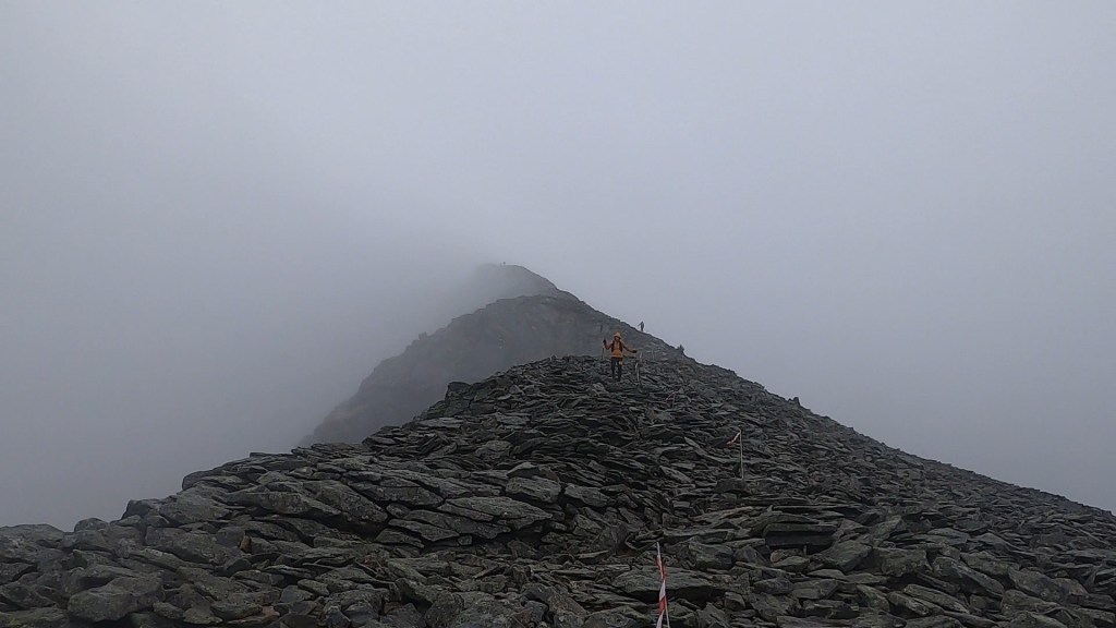
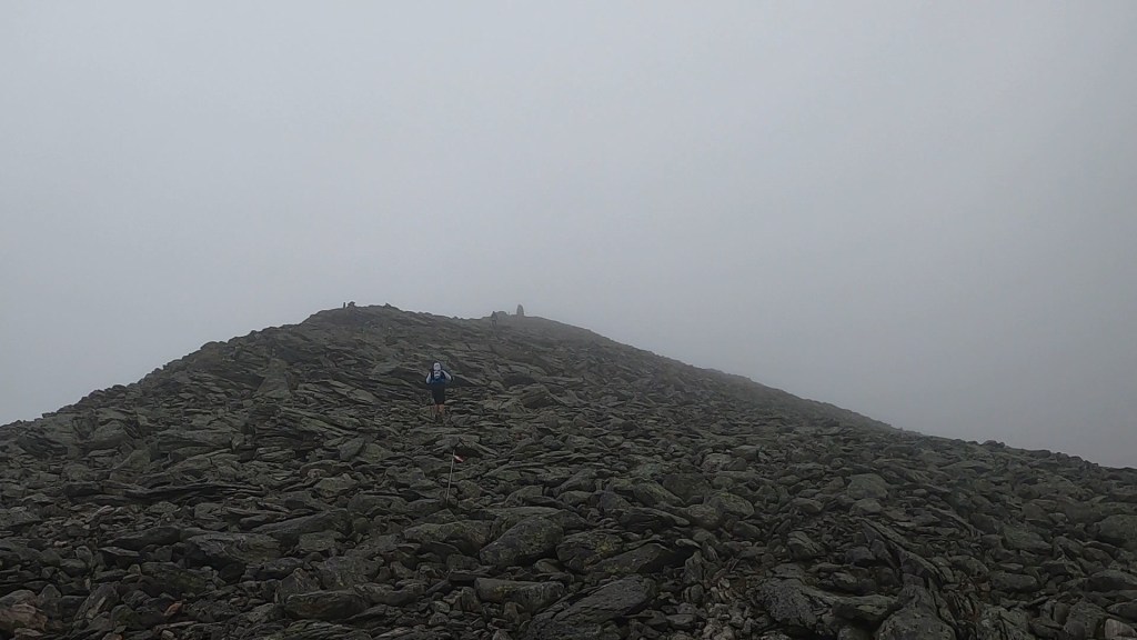
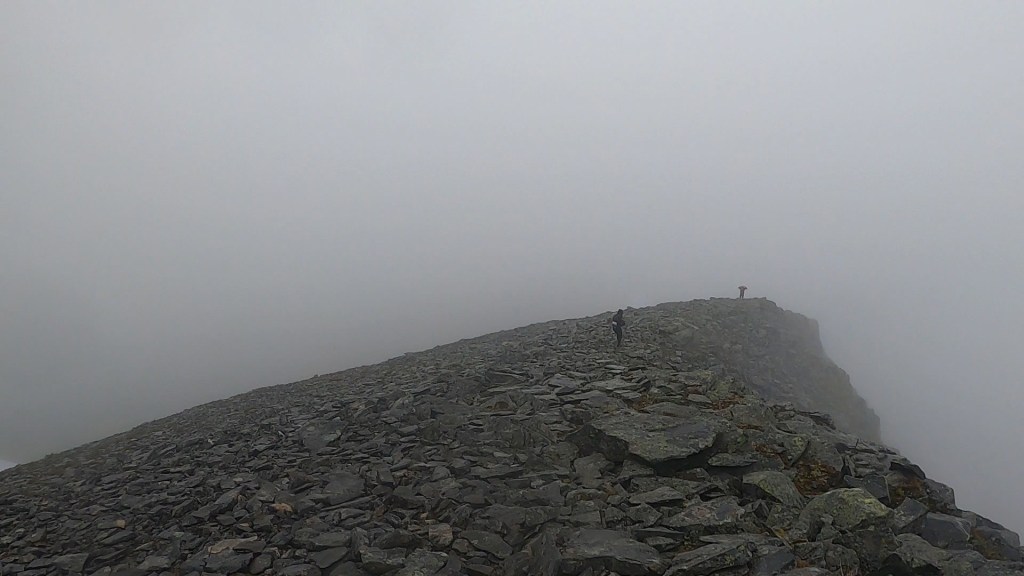
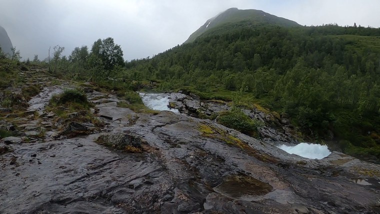
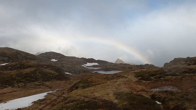
As we left we took note of the specifics of the next section. At 24km it was the longest of the route. It also had one of the biggest climbs (although still a mere baby at about 450m) of the route. We started the slow climb. Stopping shortly so Matt could quickly assess and fix his own feet after feeling some discomfort shortly after leaving Brustranda. With a long way to go it wasn’t wise to wait until we next stopped. This gave me the chance to take on some food. As we started off again the climb started to increase in steepness. We meandered through streams and muddy tracks before huffing and puffing our way up into the clouds. The climb was broken up slightly as we made our way towards Vårliheia and Tjønndalsheia. Up top, there was snow on the ground in places but otherwise vast hills of nothingness. The views were endless but the terrain barren and bare. It snowed a little and the wind really picked up so we tried to keep moving and get off the summit as quickly as we could. Mostly off track, we made our way down along soft (of course wet!) lumpy ground similar to somewhere like the Brecon Beacons (Matt and Paul often related the terrain to the Highlands, but I don’t have that experience for comparison).

Steep green climbs with some added snow

We lost track of the route a few times and I was slowing behind Matt and Paul on the long twisting downhills. I slipped at one point in comedy fashion. The wet flat grass beneath my feet caused me to slide and turn before I fell backwards on my bum and slid down on my back, coming to a gentle stop in the wet grass. I laughed it off but was a little annoyed at how wet my gloves now were (these were my dry gloves that had been kept dry when wearing the waterproof over-gloves in the rainy sections) and how cold my hands would now be. Still, nothing to do other than pick myself up and try and catch up with the others.

amazing views up high

Once regrouped we emerged off the mountain and back on to a road. Here we’d follow the road all the way around the lake Innerpollen. Whilst thankful to once more be on a dry and stable road, it was a good 17km that lay ahead of us. The view of the lake from the mountain put it into daunting perspective – it was a long way to run after more than 100km and almost 25 hours of running!

I find that in most long distance, endurance runs there is a section where the memory becomes a bit of a blank. This navigation around Innerpollen was it for me in Lofoten. For Matt and Paul too I suspect. I can recall the road, the views, how we were feeling and the distorted passage of time. What I can’t recall is how it took us as long as it actually did! Looking back at the GPS data, it took us about 3 hours and 20 minutes to cover about 14km after we got down and away from the mountain. Almost twice as long as the 10km section leading in to Brustranda when we were hurting and plodding around the coast. At the time it felt long, but it didn’t feel like it was that long! We were very tired now. The weather had dried up and it was warmer than at any point in the last 24 hours. The problem now was that all three of us were bonking at the same time. This is quite unusual that we all become so synchronised in our tough and difficult periods. Normally at least one person is in a position to take control and lead, dragging the others on with a bit of intention. Not this time. I think in our bonks we slipped into a state of limited consciousness. By that I mean we were moving forward, just with limited momentum and purpose. We were stumbling side to side, each of us closing our eyes and experiencing little day dreams (I kept jaunting awake when I repeatedly mistook the white lines on the roads as planks of wood at head height that I was about to walk in to!). Matt was doing his best to try and keep us focused, trying to engage us both in conversation. He did a great job, asking simple and specific questions to generate discussions and get us talking. Sadly I don’t think Paul and I were that responsive though. I also recall the endless amount of toilet stops I needed along this road. I don’t think I’ve ever been so hydrated in my life!

As our stumbling continued we focused on the next check point at Torvdalshalsen where we’d get our final drop bag. We’d already agreed that we needed another power nap once we reached the check Point. There would be a few mountain passes and ridges to overcome later in the course and we weren’t in any fit sate at that point to attempt them. As we neared the checkpoint we started to be passed by the leaders of the 50 mile and 50 mile relay races. This gave us a little focus as we clapped and cheered them passed.

In the distance the pink flag at the aid station could be seen. We made our way there, smiled and laughed with the race director and volunteers as we entered, retrieved our bags and went to sleep with our heads on the table once more. I requested 15 minutes on the timer this time and Matt obliged. As we woke we found another lady on the hundred mile race had caught up with us. I was happy for her as I remember her from the aid station at 20km and she was worried about making the 14 hour cut off at Napp. It also shocked us a little into action. She was once more worried about the next cut off, so Matt started crunching the numbers. She was right to be worried. The calculations weren’t good news! We had about 27km to go to the next cut off (around 144km in) but only 6 hours to make the cut off. Given progress throughout the last 28 hours, this was going to be tough. The profile of the next section just made it a struggle before we’d even begun. The next 15km had a lot of the ‘lumpier’ sections of the route with 2 climbs of about 350m each. Sandwiched between them were smaller climbs and descents. Once we climbed the second mountain and descended to the coast we then had a 12km road section to the check point with the cut off. It was going to be tight. We set ourselves a target of 4 hours for the first 15km in the mountains and then 2 hours to navigate the coastal road. It was ambitious but it was all we had. I patched my feet once more, fresh socks and fresh shoes and we headed back out.

By now loads of 50 mile runners had passed us and we could see the route way off in the distance marked by dots of runners ahead of us. Refreshed and up against the clock we were moving with purpose again. The first climb was arguably forgiving in terms of terrain with a well defined single track leading the way. We passed some photographers we remembered from the boat ride the day before and they cheered us on. We were feeling it, the joy of the trails and the pressure of the chase. We were blocking out our pains now and power hiking up the hill and jogging where we could along the flatter parts and descents. In between the two big climbs the trail descents again gave way to the mud and we found our progress slowing. The flatter sections connecting the climbs were off track along more soft, marshy terrain with huge tufts of foliage to clamber over. I felt my right knee twist and twinge. The pain was instant, but I just added it to the list of things to ignore.

Focused and determined on the climb out of Torvdalshalsen 

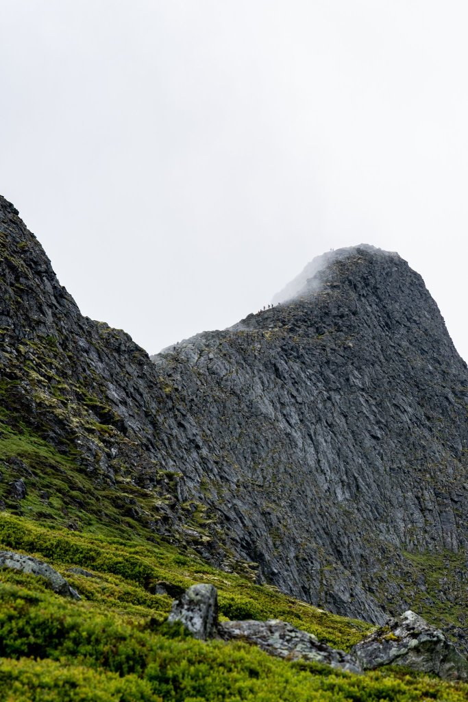
As we rounded corners and mini-summits, we followed the lines of runners. Then our Jaw dropped as we saw the ascent into the clouds ahead of us. Silhouettes of runners disappearing into the sky. Like all the climbs out here, the elevation gain was incredibly deceptive. I don’t think that 350m elevation gain is a big climb. The steepness and terrain however tells a different story. We sucked it up and slowly followed the runners into the clouds. The time pressure pushed us on and we summited with about 3 hours to go before the cut off. We were trying to estimate the distance remaining in this section and settled on about 6km or so. We thought a 1 hour downhill 6km was still achievable. Lofoten had different plans for us though. The descent began with a traverse along a ridge. The snow was falling and the wind had picked up again (it was late evening again now). In the race briefing this was one of two sections the organisers were monitoring and would divert us if the bad weather predicted took hold. The weather wasn’t as bad as expected so they deemed it safe for us to continue. Safe, but that doesn’t mean easy!

The ridge was a little intimidating. I’ve been on worse, but probably not after 30 hours of running. I was thankful though that my eyesight had fully returned (it had at some point earlier in the day but I hadn’t acknowledged it!) and I began leading us on our descent. The benefit of the ridge was that we covered significant elevation drop very quickly once we were off the ridge. The downside was it slowed us significantly and we had a real battle on our hands now. I was clock watching constantly, watching the minutes disappear. We sensed we were nearing the coast and the next check point, but the path kept winding us away in all different directions. We were back in wet marsh land, meandering through mud and streams, slowly but surely heading to the coast.

Eventually we hit the road and saw the check point in the café. It was quarter passed 6 in the evening. We were behind our pressured schedule. We had to stop and grab water and refuel. It was chaos we were all over the place, spilling drinks and food and trying the patience of the ever so helpful volunteers. We turned it around in under 5 minutes and set off. We had a little less than 1 hour and 40 mins to cover 12 km on the coastal road.

We still believed, somewhat naively, that we could make it. In our favour was a burning desire not to give up, to keep on going, to not fail. We clang to the hope of ‘its a road section’. Against us were so many factors: 130 km and 30 hours of fatigue and pain in our bodies. Our performance – at the best of times it takes me 55 mins to an hour to complete a 10km road run, to expect near similar performance now was unrealistic. The road was also against as it had ever so slight undulations and climbs, changes in elevation between 5 and 10m were enough to derail our attempts at consistent running. We also knew we couldn’t sustain a running pace for an hour and a half. We’d have to break it up with some walking.

We were plodding along full of beans and belief, maybe less than a km after leaving the check point, when Paul was crunching the numbers and working out our pace. Whilst we felt satisfied with our sub 8 min/km pace, Paul put it into perspective that it still wasn’t good enough. At that pace it would still take us over an hour and a half to cover the remaining 11km. We ground to a halt and walked the long gradual incline we were on. So many thoughts going through our heads as we tried to work out different ways to approach and over come this section. We continued with the run walk strategy and ticked off km after km. Each one we ticked off made the picture ever more clear. We weren’t going to make it in time…

It wasn’t necessarily that we couldn’t make the cut off, we still believed we could. It was more what it meant to make the cut off ever so tightly. After the next check point we still had approximately 20km to cover with the larger climb of the route and a longer mountain ridge section to cover. Before we could attempt that we at least needed a few minutes to stop and refill our water. Getting in at the cut off wasn’t enough, we really needed to arrive at least 5 to 10 minutes under the cut off. We were in a unique juxtaposition now. The more we ran, the more we exhausted ourselves and the harder it came to continually push the pace. But the more likely we’d make the cut off, but also the more likely we’d then crash and burn.

The saga continued as we reached the crossing at Sundklakk. Way off in the distance we could see the Gimsøystraumen bridge which we’d cross before the checkpoint at Kleppstad, our target. I think it was here that reality started to set in and when we really started to accept our fate. We had little over 30minutes remaining. Some 50 mile runners and, to our surprise, two more ladies on the 100 mile race caught us. We really believed we were the back of the pack, well, we were now! The other runners seemed overly optimistic (good for them!) that they were going to make it. They kept telling us it was only a few kms to go. We thought differently, believing it was longer (and were right, it was still about 5 kms before we passed over the bridge and into the check point).

The final moment of acceptance as we approached the Gimsøystraumen bridge

These 5 kms were some of the longest I’ve ever run. Fighting the losing battle against time. Defying ourselves not to give up, but simultaneously accepting more and more with each step that we just wouldn’t make it. The inevitable happened and we gave in to the long walk to the checkpoint. No amount of pushing through the pain and running would change our destiny now. We walked more and ran less. Not long after our walk lost its purpose again and we talked and cheered each runner passing us that still held onto the dimming glow of hope. After a slow walk over the bridge, we arrived at Klepsatdd. It was like a ghost town. The Arctic Triple Trail flag being the only indication that this was the aid station. We tried the doors but couldn’t get in. It looked closed and locked off, chairs on top of tables and darkness inside. Eventually Matt found someone inside who directed us to the door. We still couldn’t get in. In our tired state we’d completely missed another side door that was the way in (in our defence it was clad the same as the building!). The lady greeted us with a very stern “You’re Late”. We asked if we could continue, she didn’t see the funny side and reiterated that we were late.

Part of us did want to continue, we’d come so far after all. But we accepted our fate was sealed. The final few kms of walking had meant we were now well passed the cut off and another one loomed in less than 4 hours after the next mountain ascent and pass. No way would we have made that, even if we had made this cut off in time!

Inside we saw most of the runners who’d passed us on the road. None of them had made it in time either. The volunteers were helpful and gave us warm food and drinks and information as to when a bus would be available to take us back to Svolvaer. There was one leaving soon which we might have been able to jump on but in our politeness we let someone else take the last spaces. We might not have been so polite if we’d realised we’d have to wait another hour for the next one!

Back in Svolvaer we had to walk to the finish line to return our trackers, collect our bags and ponder “what could have been” watching people finish the race. The consolation was a lovely fish burger available to runners which certainly warmed us up and filled our bellies a little. It was now nearing midnight and I was eager to wash the bogs off before getting some sleep and beginning the long journey home the next day…

Reflections

  • What an adventure! Lofoten is so wild and remote. The little villages we ran through were so isolated and peaceful. The back drop of towering mountains and the ocean is an incredible combination. It is such a beautiful place and one I’m glad to have explored a little.
  • Despite the result, we loved it. The race organisation and volunteers were fantastic (the race briefing was very informative!), the check points and support were brilliant and the location was just unreal!
  • The boat ride only made the whole experience even better!
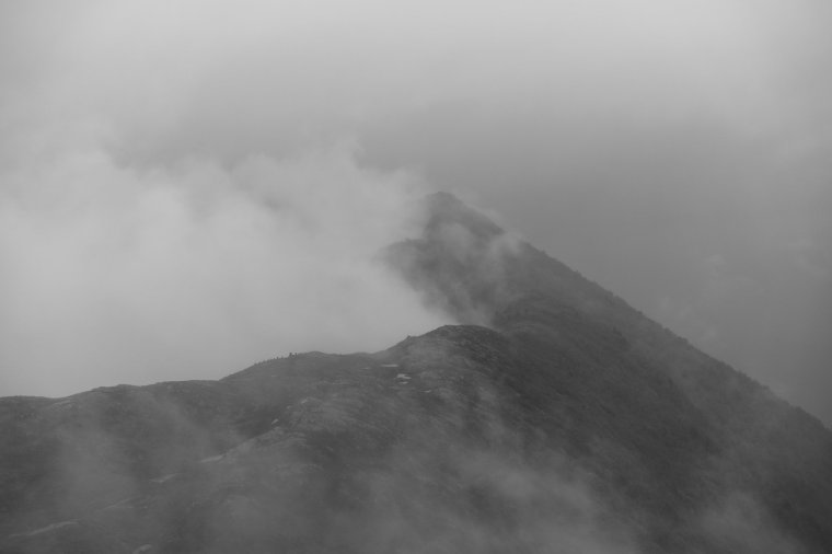
  • The terrain out there is gnarly! I’ve done a lot of trail running around the world on some difficult terrain. This was something extra though. I described the mountains like someone had chopped the tops off them and just placed them close to the sea. At only 300m – 500m+ elevation it felt like you were over 2000m up. The mountains very quickly become steep, sharp rocks. The weather up high changes rapidly and varies significantly from that just a few hundred meters lower down. When not in the mountains, it is just wet. Consistently probably the longest I’ve spent in bogs. Far more so than runs in Snowdonia and the notoriously boggy Cheviots!
  • A phrase Paul used was “you’re not in Kansas any more Dorothy”. This was so true and to the point. A lot of the ‘big’ European races in the likes of France, Spain, Italy, UK, Austria, Switzerland etc., have exceptionally good trails. If you’re looking for well maintained single track trails, this part of Norway is not for you.
  • I thought the road sections would make it easier. I anticipated we’d have greater control over our pace and when we ran and when we walked. They didn’t, they just sapped our energy and enthusiasm. Our bodies had different plans for the roads. That said, the landscape was still incredibly beautiful, even when running along the roads.
  • My perception of time has been completely warped. I’d describe this as one of the harder races I’ve done. Although, making the vaguest attempts to compare races – we covered the 100km distance in about 6 hours less time than it took me to run Transylvania 100km the week before. Compared to the more forgiven Alpine and Pyrenees trails, we were on course for a far quicker 100 mile time than what we achieved at Val D’Aran or UTMB (broken ankle aside!). This felt longer and harder in parts than these races. The cut-offs are tighter that is for sure!
  • Let’s be straight, we failed. I hate all the self-motivating and congratulatory crap around ‘but I did not fail’ people use when referring to DNFs (Did Not Finish) classifications. We absolutely did fail. We set out to run 100 miles and knew the cut offs. We didn’t finish the course and we didn’t achieve what we set out to. Say what you want, this is a failure. It is black and white for me.
  • The failure doesn’t subtract from what we did achieve though. 90 miles and 32 hours – it was one hell of an adventure and exactly what we signed up for. Only 22 of the 47 starters went on and finished the 100mile event.
  • Looking back, how do I feel about not finishing? Surprisingly ok about it. Yes it hurt, yes it was frustrating, yes there was and is still disappointment. But I’m ok with it. There doesn’t feel like there is anything to ‘deal’ with. We had the adventure we set out for, we’ve memories that will last a life time. I think I’d feel differently if we were timed out earlier – image it happened at Napp after 56km, then it be pissed and annoyed and would definitely feel a need to try again. As it stands I am completely at peace with it. I don’t feel a desire to got do those last 10 miles.
  • Perhaps I’m ok with the DNF because we didn’t give up. Right up to those last few kms we were fighting. If it was an option, we definitely would have continued as well. I believe there is a big difference in not finishing because you are timed out or medically withdrawn and whether you make the decision yourself. Maybe I’m being arrogant, but the decision was made for us, that makes it easier to stomach.
  • Where did it go wrong? Immediately after, and for the next few days we couldn’t really figure out. We felt we were ok. Possibly we were just enjoying it too much and took our eyes off the cut offs a little too. Thinking back there are a few clear places. The stops – time at check points was very much needed, but a few 30 min stops plus the hour at Napp certainly affected our overall time. Mainly though, the road section around Innerpollen is where I believe we lost too much time. All three of us succumbing to fatigue and tiredness at the same time meant we just took too long on this section, far longer than it should have. Ultimately though, we just couldn’t cover the terrain quick enough. That is on us. And not something that I think has any real learnings associated to it. The route and course was just better than us and more than we were capable of.
  • Norway might be my running nemesis. Trails are a bit different there. Last year Stranda Fjord almost had the better of me (and I would have been timed out there too if it wasn’t for changes to the route due to the weather conditions!). Possibly the hardest race I’ve done. This year Lofoten finished me off. I’d quite like to live in Norway though!
  • We got Viking’d. Pillaged and laid to waste.

Fuck You

When recapping my last race I mentioned how, during the Eiger Ultra Trail E101, I fell over for the first time in a race. We’ll I think it was a floodgate moment. In my next race I must have fallen about 50 times, no exaggeration, I spent a lot of time on my backside in Norway…

The Stranda Fjord Trail Race in Norway had been on the cards for a long time. Originally I signed up to the race back in 2019 and hoped to do the inaugural 100km run in 2020. But we all know what happened that year and the same cause meant 2021 also wasn’t possible for us. Oscar, the Race Director, was incredibly supportive in deferring entries until we could travel to Norway and race. So in 2022, a slightly smaller than planned group of us headed out to finally run in the fjells of Norway.

In the days leading up to the weekend it became increasingly clear that the weather was going to be less than ideal for the race. Clouds and rain meant a weather warning and amendments to the 100km route were activated for safety. At this point I was kind of ok with it. We can’t control or change the weather, and I was expecting the route to be very difficult. So removing some of the most difficult sections would be in my favour I thought. A small benefit to missing out on the legendary panoramic views from Slogen.

Nick and Natalia woke at 1am to escort me down to the town of Stranda for the start. An unnecessary and kind gesture from them both given they would need to wake up in a few hours to prepare for their 48km race. After collecting my GPS tracker I sat inside the building (where we collected our race numbers) with the other runners, waiting until it was almost 02:00 and time to run. We first lined up under the finishers arch before being led around the corner to the real start line. Here I fell for the first time, stepping in a hole in the concrete pavement, before the race had even begun!

Section 1: Start –Duklidalen

The course starts on the town square in Stranda. From Stranda you will first be running a few km on a asphalt road until you hit the trailhead on Framhus. From Framhus you will be running on a nice trail up to Dregetua (693) and then off trail over to Vardnakken (878masl) and further to Blåhornsvatnet on trail. From Blåhornsvatnet you will be running on a nice trail down to Vasset. From Vasset you will be running a few km on a gravel road until you hit the trailhead for the trail towards Lievarden (799masl) and Duklidalen (820masl). In Duklidalen you will find an aid station.

Excerpt from the Race Manual

Moments later and we were off, running the tarmac road switch backs for the first few kms. I was pleasantly surprised at this point that we stuck together mostly as one big group of runners and that I hadn’t been left behind completely.

The roads soon gave way to the forest and we began running in single file in the darkness. And it was very dark, something about it felt darker than the usual nights I’ve experienced. Though the trails were clearly lit by the dozens of head torches bobbing about.

Mostly it was silent now other than the sloshing sounds as we ran through puddles and muddy trails. I felt that most runners were, like me, trying to avoid getting their feet wet. I accepted that it would be wet but didn’t plan on being waterlogged for the whole race so was happy to skip around the trails when I could. I should have known better that weeks of rain in this area would have meant the ground conditions would be far worse than I imagined! It was soon clear that the trails would consistently be this way at the best of times.

Through the forests two things stood out in my memory. Almost getting lost – the spacing between runners was now increasing and a few of us lost sight of the runners ahead of us and this section was not course marked. A quick stop and check of the GPS and we were back on track before the damage was done! And a point where there was a delightful bunch of supporters with coloured lights and music who cheered us through one small section of the track. It created a good atmosphere and led to a few of us to start talking. Whilst talking to a few climbers who were doing the race it made me realise that most of the runners around me were head to toe in waterproofs (or wearing hiking trousers!) and there were very few like me in shorts and tshirts without a waterproof on. Even though it was drizzling with rain, I knew though that I’d overheat on the early climbs so was waiting until the climbs were exposed before I’d layer up.

After a little section on some wider gravel roads, the forests returned and became a little steeper and very, very muddy. Every now and then a series of wooden walkways assisted in avoiding much of the mud. The forest soon gave way and the mountain opened up into a vast exposed climb. The single tracks we followed, still trying to skip around the mud and bogs. So far so good although it was now very windy and cold (the drizzle of fine rain had become more constant now) so I took a moment to layer up with my waterproof jacket.

We continued climbing before reaching the first of the smaller summits (which must have been Dregetua) marked by a stone trig pillar. We then began descending and running again. I set off and was enjoying seeing the head torches of other runners way off in the distance. Here though it was becoming increasingly difficult to avoid the mud as the narrow tracks left little room to manoeuvre as the ground was so uneven. It wasn’t long before I was soaked to my shins and covered in mud. At one point my left shoe came off, stuck and wedged in the mud completely. I had to bend down and pull with both hands to get out back out. I took the moment to tighten both my laces! We then climbed a little more in similar lumpy conditions which was quite tiring on the terrain and in the cold of night. The heat from the first bit of climbing meant my t shirt was soaked with sweat so I couldn’t really avoid getting cold even with the jacket on!

From the next trig point (Vardnakken) we began descending. Down we went through a long series of lumpy bogs. The undulating terrain meant it was quite difficult to get a good rhythm when running. One foot would descend then next foot would ascend a lump. I felt like I was jarring up and down and running very inefficiently. There were rocks hidden in the darkness too.

Once more my shoe got sucked off (the right one this time) and after retrieving it I tightened my laces even more. They were so tight now that they weren’t particularly comfortable. But thankfully they never came off again!!

Stranda at night

The descend was consistent until we reached Blåhornsvatnet. From here the descent became steeper and significantly harder. We we going down muddy and rocky switch backs, sometimes off trail, sometimes through streams and always having to look and see which way was the most obvious. It wasn’t long before I was on my arse and covered in mud. Within a few minutes I had fallen multiple times. The mud was so thick that there was no way to grip it properly. Whilst my Inov8 Trailrocs aren’t ideal for muddy runs, I also couldn’t imagine many trainers being much use here! I wasn’t alone. I could hear the gasps and groans of other runners in the night too and could see runners in front of me falling over.

I was already thinking to myself that this was the least fun I’ve ever had in a descent. It was relentless and torturous and I just had to accept it. Accept that it would be uncomfortable and that I’d keep falling. So I just kept moving, letting gravity pull me down, hoping it would be done quicker that way. There were a few points where I just ploughed straight through bogs above my knees and had to drag myself out with my poles. There would be no warning as the ground just sucked you in. Mostly though it was just about shin high. I remember thinking to myself that this was suppose to be the easiest section of the race! The alarm bells were ringing. I then took an almighty slip, skidding a little bit on my heels before twisting and going down on my left side. I know I swore loudly (not for the first time) and I heard a sound from my pole which I landed on top of. It sounded like a crack but I hoped it was just the sound of it hitting the the ground and my weight on top. Once again I picked myself up and carried on, thankfully the trails finally came to an end and we had a section of gravel track to run on. It felt quite long but soon enough we were climbing again (which I believe meant we were now connected to where the 48km runners would start). The gravel was a welcome change and I took the opportunity to remove my jacket again. I was also surprised how quickly my feet and shoes seemed to dry out. It was around 04:30, the morning was breaking and the sun starting to rise, giving a glimpse of the amazing views of Stranda and the Fjord below us.

Inevitably the gravel road became a forest track and the climb became harder as the wet ground and mud returned. Over the course of a few 100m of climbing the tracks became off/track as the mountain opened up to us. The tracks returned and brought with them incredible views off to our left of the Fjord and over to Liabygda. I stopped for a few minutes to layer up again as the exposed mountain meant more rain and the temperature had dropped as the wind picked up. It did give me an opportunity to absorb the views all around me in the early morning mist.

Morning was breaking

From the climb we descended again, the tracks weren’t too steep but they were very wet and we ran on waterlogged tracks and bogs from the many streams. Up ahead a tent could be seen alone in the wild. The first aid station at Duklidalen and the first opportunity to eat something!

I checked my watch and timings and I had covered the 20km or so in pretty much the time I estimated I would. Not a bad start considering the state of the trails!

Section 2: Duklidalen – Fjørstad

From Duklidalen you will be running on and off trail up the Mønet. There are sections here that´s up to 45 degrees steep, you will have to use your hands at times on this section. Mønet is a cliff with a several hundreds meter drop on the fjord side, be careful and stay on the trail. Further on you will be on and off trail in scree up to Fremste Blåhornet (1478masl). From Blåhornet you will be running off trail along the ridge high above the fjord over Rjupskartind and towards Åknesnibba (1296masl). This section is very technical as the ridge is narrow with drops on boths sides. We recommend you to be catious here. There are parts where light scrambling is involved on this section. Before Åknesnibba the course will take a hard right turn down into the valley with a steep technical descent down, this is also a good place to be xtra catious. Then along Rjupeskarvatnet, and further out Fjørstaddalen past Heimfjørstadsætra and down to Fjørstad on a nice trail. On Fjørstad you will find an aid station.

Excerpt from the Race Manual

Immediately from the aid station we began making our way to the ‘wall’. I believe it was the cliff called Monet. But to me it was a wall on the edge of the world. I couldn’t see where we were heading. Making my way towards it I was texting Natalia ahead of her race and slipped and fell again. This one was my fault for not paying attention. The ground was soaking wet and cold where I fell.

SFTR official photograph of Monet. There was only one other runner on it when I climbed the cliff

As I reached the ‘wall’ it became clear we were climbing up it. I could see runners scaling it and became apprehensive. It was steep. I held my poles in one hand and used the other to pull myself up with each step. I dared not look down but accepted that it wasn’t as bad as it initially looked and I was at the top maybe 15 minutes later. Up top the grassy cliff turned to rock almost instantly. The climb however continued.

Looming in front of me was a giant of a mountain. Grey in every way. Grey rocks. Grey clouds. Just grey. I assumed this was the first change in the route and this is where we wouldn’t climb. I was wrong though. People ahead of me kept going further up and disappearing into the grey clouds. I put on my gloves as it became colder the higher I went. I then put away my poles and began climbing on all fours. It was quicker that way. I briefly started talking to Kristofer who’d done the 48km last year, who explained this was just the climb to Fremste Blåhornet (I believe he called it ‘Front Bluehorn’) and that the removed part of the course was further up still. He powered on passed me. Eventually I made it to the summit and the timing mat and turned around. Now we were on the diversion route which meant going back the way we came then across and down a valley.. There were a few runners ahead of me but they soon disappeared into the distance as I move so slowly over technical descents like this. I kept watching and making mental notes of where they were and went so I didn’t get lost. I felt alone now, for the first time in the race. I soon couldn’t see runners ahead nor behind me.

After completing the rocky downhill the diversion route took us left and away from the next climb. There was no path though and it was an off track descent from here to the next aid station Fjorstad. I was beginning to see the pattern now and off track terrain meant crossing lots of streams, slipping loads in the mud and bouncing up and down with the lumpy ground. Every now and then I’d get a glimpse of a single runner ahead and another behind me. This was another down hill I did not enjoy. I was initially glad when the route entered a forest area but that happiness soon gave way to frustration as the mud returned with a vengeance. Once again I was constantly on my bum. I started saying “fuck you” loudly. Like a chant. Every time I stubbed my toe on a rock “fuck you”. Slipped on my arse “fuck you”. Stepped in a bog or stream “fuck you”. It became my mantra as I continued tumbling down.

Off track descent

Finally the forest let me free and I ran the small down hill to the aid station, slipping and falling for the supporters and volunteers to enjoy! We all smiled and laughed knowing I wasn’t the first and wouldn’t be the last to provide the entertainment.

The aid station was a good one. Kristofer was there and changing into spare clothes. On this race you could have a drop bag at each station. I’d opted just for one at the 63km point. I regretted it slightly seeing Kristofer change into dry clothes as I was soaked through. It was warm inside the building so I packed the waterproof away again and noshed down on plenty of watermelon, crisps and cinnamon buns.

Section 3: Fjørstad – Habostadsætra

From Fjørstad you will be running the asphalt road down the Strandavalley for 4km and then into Moldskreddalen on a gravel road for 3km to Mesætra. By Mesætra you will hit the trailhead to Storhornet and cross the river on a bridge, and start the climb up to Storhornet (1309masl) on and off trail. Parts of this trail is technical. After summiting Storhornet you will turn around and follow the course back down for 1km, and then turn right and hit the trail down to Habostadsætra. Ths downhill section is very steep but the trail is very nice. On Habostadsætra you will find an aid station.

Excerpt from the Race Manual

Before long I was back out running with Kristofer on a long road section. It felt good to run. I’ve never wanted to run along a main road with cars driving passed me (very safely and courteously I should add!) so much in my life. It felt like it was the first time I could actually run. It was also a strangely therapeutic few kms knowing I could see this road from our incredible mountain accommodation.

From the road we were once more on a gravel track uphill before, yep, you guessed it, we were back in the wet and slippery forest hiking off track up a steep climb. Kristofer started getting further and further away as I huffed my way up. Once out of sight I had to concentrate more looking for the red trail markers painted on trees or rocks. This climb felt like it took so much longer than it probably did. After the forests it was wild and rugged terrain. Up and down lumps whilst still generally getting higher. There was a person out here all alone. It took me a while to realise he was a photographer. It took a while longer for me to get to him, he waited patiently and snapped me as I said hello and made some bad jokes. I asked if it was Ian, and it was. A world reknown adventurer and photographer. I’d read his blog from the 2021 event and we had a brief chat comparing the contrasting weather conditions. He kindly shared some advice on the climb and temperatures awaiting me and wished me well on the journey.

Photo by Ian Corless

From here things got a little harder. The climb went off for an out and back section to the next summit of Storhornet. It went ‘up’ pretty steeply and the trail was more prominent and clear for a short while as the the mud and wild terrain tagged out and the went rocky tracks tagged back in. There were many runners coming back and I’d let them glide effortlessly passed me. I had no idea how far I had to run to get back to this point. But up I went. There was another photographer filming runners coming down and he had to film me slowly walking up. I made it clear I wouldn’t be running down like they all were!

Like the Blåhornet summit, this one became very rocky very quickly. It was now just like before as I was stumbling from rock to rock heading into the mist in the direction shadows were coming from. Here I had one moment that ‘threw’ my mind a little off. A lady was coming down and started speaking to me, I assumed in Norwegian, and I explained I only spoke English. She then told me that it was very cold further on and asked if I have any more clothes to put on. I was caught off guard. Whilst her intentions were no doubt full of kindness and support of other runners, I didn’t quite understand the comment. There was mandatory kit and I was clearly in the race with a full bag on my back I also had on my waterproof coat and gloves on, so I don’t think I looked under-prepared compared to anyone else. I assume she was concerned because I was just in shorts. But I reassured her I was fine and carried on. Soon Kristofer ran back passed me and sometime later I looped around the summit and too was heading back down. On this section many runners overtook me as I once again descended so slowly.

Eventually I completed the out and back and was then going down a steep hill in another wet and slippery forest section. I was all over the place. Sliding and slipping everywhere going down the switchbacks. A lady behind was asking if I was ok as I was swearing constantly. Then it was her turn as she slipped and did a pencil roll down one bend/turn. I can’t quite describe how fantastically she rolled and ended up down ahead of me and back on her feet laughing at her ‘shortcut’. She then sped off descending rapidly with ease. She called back to check on me a few mins later when I let out a rather loud expletive laden cry. I was ok. I’d fallen again (Fuck you!). This one was worse though. Whilst I was fine, in the process I’d snapped my fucking pole again (I snapped one in the VDA last year). I was really pissed off. It snapped right at the handle where it slides in and the locking button is. It was fucked and useless now and I’d only covered around 40km of the race. In a mood I carried on into the aid station that wasn’t far away.

A few runners looked at my pole and the volunteer was a superstar, running around looking for things to fix it (his plan was to tape a small rod to the handle to strengthen it). I knew it was a lost cause though but I appreciated their efforts. I filled my sorrow with meat soup (which was frikken ace) and Coke. The aid stations were pretty great for variety in my eyes! I checked my timings and, once again, felt I was pretty spot on to plan as it was about 30 mins before the first cut off. And so, having experienced running with one pole before, I knew I could overcome it, I packed it away and carried on with the single pole.

Section 4: Habostadsætra – Myrsætra

From Habostadsætra you will be running on the marked DNT hiking trail trough a lush birch forrest to Nysetvatnet with a great view towards Brekketind and the Brekketind glacier and then further to Patcellhytta where the climb to the iconic mt. Slogen (1564masl) starts. You will be running on the marked DNT hiking trail up to Slogen. The last part up to Slogen is very steep and involves scrambling, be catious on the way up and down. From Slogen you have a majestic view over Hjørundfjorden. The summit is very narrow, so one have to be carefull on the top. Here you will turn around and go back the way you came up for 1,5km. But instead of going back down to Patchellhytta, you will turn left and continue towards Isavatnet and further down Langseterdalen past Storevatnet on a nice trail. At the parking lot at Myrsætra you will find an aid station.

Excerpt from the Race Manual

The next section began with us walking up a stream. Really?! Fuck this trail I thought. I was waiting for the pain of constantly wet feet to kick in. Like the rest of the route, there was nothing to do about it except power through. It was kind of up hill, but very gentle and certainly not runnable (for me) as it was mostly rocky. My power hike was in full flow though and I was enjoying the intimating views of the mountains surrounding us on all sides and thunderous roar of the river besides me. Off in the distance I could see the lady along with another runner. I kept thinking I was gaining on them but I really wasn’t. The section was another that felt like it went on for a while, but I was content knowing we were at least climbing gradually higher. And so my mind wandered a little. I got thinking back to that last aid station and my timings and realised that all wasn’t quite what it seemed. Whilst I was ‘on time’ and within the cut off. We hadn’t done the climb from Blåhornet nor the ridge or its ‘more’ technical descent. That was the very technical section and no doubt a harder descent for me. So I highly doubt it would have completed that longer section of the route in my spare 30 minutes. I realised I would have been timed out at the first cut off (which was 13:00 at the last aid station) if the route hadn’t been changed due to the weather. I clang onto the hope that if the weather was better then the terrain would be less muddy and I might have moved a little quicker!

Streams, rocks and rivers

In the distance there was a little mountain hut of some sort and a guy out sweeping the decking area in the rain. It amused me. As I walked passed a volunteer called to me and waved me up to him. I checked my watch, yes, I was mindlessly following the two in front. I called after them and they walked back to join me on the climb. Each climb in this race seemed to find a way to be more challenging than the one before. This one was just a pain to start with as the terrain fluctuated between single track and off track frequently and we traversed so many streams and flows of water down off the mountain. It was just miserably wet. Like the number of times I fell, I wish I’d counted the number of streams we’d crossed on this course, I’m certain it would be hundreds. The mountains were leaking water everywhere due to the recent weather. It only stopped the higher we got. And it only stopped because the terrain became rocky. Once more we were playing dot-to-dot connecting the red trail marks and traversing the huge boulder fields.

There was a giant sleeping here. To my left I could sense and enormous presence and was admiring the mountain in the clouds. It was Slogen. The original route included an out and back to summit of Slogen for ‘panoramic views’. But we wouldn’t be doing that today. I was glad. This was also one of the hardest parts in the race so I was relieved to be skipping! Instead we carried on straight passed it. Straight into and across the snow fields. These were fairly short but difficult with one pole and not so aggressive soles on me shoes.

The first of many snow fieldds to cross

After some time we began our descent towards Myrsætra. This is where my drop bag would be. So I was in good spirits anticipating it. But the descent was tough. It was, you guessed it, rocky. So the the three of us moved slowly. I don’t remember much more than passing down alongside some lakes and rivers. I do remember we were in a valley and it reminded me a little of a section the TDS route in how it looked (but harder!).

in the Valley

There was plenty more falling over here too and I was losing track of my orientation and where we were going. The lady reminded me that soon we’d have the out and back to the aid station to the left and then we’d go back to the right to climb out of the valley. It made sense when she explained it.

Oddly, here I also realised my eyesight was a little hazy. I could see ok, but it wasn’t crystal clear. Almost as if I had clingfilm on my eyes. There wasn’t anything I could do and I assumed it was a combination of tiredness, constant concentration, the wind and the rain and perhaps the white glare from the snow. Anyway, I wasn’t worried, but I was conscious of it and to keep an eye on it (Whey hey!)

We reached the out and back section and now, like before, saw runners and familiar faces going in the opposite direction. There were a lot less of them this time though! I didn’t know how long it would be to the aid station but I was aware of how wet and muddy the track was again. I immediately decided that I would not be changing my shoes or socks. My socks would be soaked as soon as I changed them so I thought it wasn’t worth the effort. As I rounded the last corner into the aid station I had one of my best falls yet. I slipped in some mud and both feet went up in the air, above my waist, as my hands and head threw up behind me with the motion. I landed on my bum and back straight into a boggy patch. I was covered in mud. The volunteers laughed as I arrived (they heard the ‘fuck you’ scream) and I apologised as I sat straight in one of their chairs and covered it in the fresh mud. I ordered more soup, ate more cinnamon buns and finally changed into a dry tshirt after 14 hours.

Not long after the three of us reached the aid station, we were shortly followed by a fourth runner a Polish man I’d been near throughout the day. We sat and ate and drank and joked with the volunteers. We had our own little party before cheering ourselves back out knowing we had five hours to cover the 10km to the next (and final) cut off. Easy we thought… Wrong…

Section 5: Myrsætra – Brunstad

At Myrsætra you will run back up the same trail you came down up to Langsætra where you will follow the DNT marked trail up to Gullmordalsvatnet passing by the Gullmorglacier along the trail (you will not be running on the glacier). This section is very technical and you will be running parts of it on scree. After passing Gullmordalsvatnet you will be on the top of the Gullmorbrekka (979masl) pass, from here you will be running technical downhill to Velleseterhytta and further on gravel road down to Brunstad where you will find an aid station. This is also the location for the the cut off time at 21.00.

Excerpt from the Race Manual

The first section was ok. It was a repeat of the out and back. After which we we were constantly looking for the trail. This section wasn’t marked by the race and no red trail markers could be seen anywhere. We followed our GPS and would be on what seemed to be a trail, then all of a sudden the GPS would say the trail is off to our side by 50-100 m. This meant we were zig zagging up the climb. Crossing all sorts of wild terrain to ensure we kept heading in the right direction. Every now and then the Polish guy would appear from nowhere. He was having the same navigation issues. After an ‘age’, the lumpy foliage turned to rock. But that didn’t make it any easier and the same thing would happen as we’d turn at right angles to try and maintain the correct direction. We at least could now occasionally see some red trail markings on rocks though.

At this point we were sticking together as a foursome as we crossed many more snow fields and rocky sections climbing and traversing our way out of the valley. The lady, who was from Argentina, lady kept kindly offering me her poles as I was really struggling on all the snow crossings. So mostly I was behind them all and would time to time shout out when I thought we were ‘off route’ again. To me it felt like it was night time. We were deep in the clouds and the grey-ness of the mountains. The only light was coming from the snowy floor we trudged over. It was surreal and disorientating at the same time, yet it was only about 17:00.

We were trudging across another snow section when I noticed we we starting to get further from the trail, which was going off on a sort of angle above us. We stopped and debated for some time where to go and eventually agreed we shouldn’t continue on the snow. For one thing, we couldn’t see any recent signs of activity on them! The issue however was that the snow was sloping and above it was a wall of rock. It didn’t look feasible that the route could be up there. But that’s what the GPS was saying (and scrolling out we could see that the route would turn further that way after about a km further along). If we carried on the snow instead we’d soon be far off course and could see nothing ahead to make us want to continue (into the unknown).

So we back tracked and headed for the rocks. It took me a long time with one pole to get up to the rock and my troubles didn’t stop there, the climb facing us was a beast. It was essentially bouldering and rock climbing. I was trying to use strength from my arms which I just do not have to haul myself up onto rocks. And it was all loose. Admittedly I was scared. Actually, very scared. A fall here would be bad. A certainty of a serious injury and likely a very long wait to be rescued. I was glad I wasn’t alone and Argentinian Lady was very supportive and looked after me with constant reassurance. I knew we had to keep going though and that we should even get a little higher to be safer and further from the steep drop.

The climb, even just covering a few meters, was very slow. We were barely moving and the loose rock was causing us difficulties. Several times we knocked rocks back on each other, one time I released a sizeable one that went tumbling down. My warnings weren’t enough for the Polish guy to get out of the way in time and all he could do was raise his arm to protect his head as the rock fell straight into him. I felt so bad, but he reassured me that he was ok, just annoyed by the situation. It only added to our frustrations and concerns of safety.

We were at least now tracking in the right direction according to the GPS and the rocky climb eventually gave way to firmer ground, albeit more snow capped fields. I thought it couldn’t get worse than that section, but I was wrong (again). We were now faced with another directional dilemma. The route indicated we needed to leave the snow and descent a very narrow, very steep rock face. I looked over the edge and it felt like an abyss, the end of the world. Meters below us all I could see was a dark grey mist cloud wrapping the mountain. I couldn’t see a trail or path. It is fair to say I was not keen and I didn’t want to go that way. The alternative though was to remain higher up and walk along the snow covered mountain. I’d had enough of them though and we couldn’t see far enough ahead to determine where we would go or how we could re-join the path if we did continue that way. It felt like ‘down’ was actually the better option. Two of us started to descend…

Kamil emerging back from the abyss

I was still on top of the snow when, in the distance, a lonely figure, in a bright blue coat, emerged through the clouds with his hand in the air waving. I didn’t know what to think. He was clearly gesturing to us so we called back to let the others know someone was coming. We walked on and met him. He explained he was a volunteer from the race and he’d show us the way. He confirmed we could go either way, but the snow might be the easier route for us. So we followed him.

He was moving so effortlessly I struggled to keep up. He pointed down a steep snow slope and said we can go down here. And off he went, sliding, skiing (without skies) down hill. The French guy went next and pretty much made it the whole way standing up too. I followed and immediately landed on my arse. I sped down like I was on some sort of toboggan, bouncing up and down with the lumps. In no time at all my arse was so cold and starting to hurt with the freeze and friction. The whole thing lasted a matter of seconds. Looking back, my Strava indicates we went down a slope of approximately -50 deg and covered around 70m in descent. My apparent pace was 1:32 km per minute. What a ride!

Gullmordalsvatnet – we tracked along the edge to the right of the lake, all the way to the end

One by one we all made it and we were at least treated to an incredible view of the Gullmordalsvatnet lake and valley surrounding it. The downside, I could still see no clear trail or path. We were told that we needed to traverse along to the right of the lake. I couldn’t believe it. What?! It was just the slope/side of the mountain with alternating layers of snow and rock. How? He reassured us that as we got closer we would see some race markings to indicate the way we should go. He told us that we would need to climb and descend on the rock and avoid the snow slopes at all times. I could see why, if you slipped on those, nothing would stop you sliding all the way into the freezing lake. Game over. There was another catch though, first we would need to ascend on the initial snow slope, but not to worry, there is a rope. Fuck sake…

One by one we ascended the rope climb. This was awful for me. I had no energy or strength to pull myself up and no grip in the snow to provide any traction. It was yet another very slow ascent. I relied on a tactic of pulling myself up and looping the rope around one hand with each pull to get more leverage. I thought my shoulders would pop out here. Thankfully I soon reached the sanctuary of the rocks. Ha! Now I was thinking that the rocks were my friends!

The volunteer left us here and went back to look for the remaining runners behind us in the pass somewhere. We thanked him but I never got his name. His final words were “it is 2 hours to the next checkpoint”. I looked at my watch. We had 2 hours and 10 minutes until the cut off. Shit. I thought we wouldn’t make it, that we would be timed out. If he was saying 2 hours, it would probably take us longer. I hung on to the glimmer of hope that there might be some sections we could run and that he was talking about walking time.

We still had to travers the lake first though. Painstakingly, we looped up and down each rock section, maybe up to a 20m climb and descent each way. Looking and following the trail flags which we could finally see. Each loop required a small traverse either along the top of the snow slope or along the bottom, right next to the water. I could feel the chill coming off it. At one point I sent another rock tumbling. Down the snow it rolled and then bounced off the bottom of the slope, launching into the air and over the water onto a floating patch of ice with a ‘boom’. The lake didn’t flinch and I didn’t want to follow the rock!

As we finally reached the end of the lake, the paths did become a little easier. They were far from runnable though. Just easier than what the last few kms entailed. It was still a horrid down hill though. In maybe 3km we descended over 500m. It was very rocky and very slippery as we navigated through tens and tens of waterlogged paths and streams. There was plenty of falling over and slipping here too. We mostly descended in silence. I’m not sure what the others were thinking, but all I could think about was the cut off and whether we would make it or not. I wanted too, but I was also wondering how I’d feel if the decision to continue was taken away from me. I genuinely believed that, after this cut off, we would have plenty of time to finish (there was 13 hours for the last 20km or so). So I wondered if we were close to the cut off if I would be of mind to try and negotiate my continue. It was all theoretical, but it kept me focused. Going further down, fast hiking, moving with purpose. It as all I could do.

one of the nicer paths!

We then came upon a forest section which was far less steep than before. The trails became a little drier and other than a few big leaps across streams (with broken planks that were intended to be crossed) the next few hundred meters of descent were a little more forgiving. We still weren’t running, but were able to pick up the pace at least. We were racing the clock though as time was against us and I kept looking at my watch and doing the calculations. 50 minutes to go, 40 minutes to go, 30 minutes to go… With every step I adjusted our progression, but it didn’t really make much difference. It was going to be tight if we couldn’t run. And then luck was finally on our side…

From the forests we came across a house with a lady gardening and a man tending to the path. We ran down, said hello and left through their gate. He wished us well and said he hoped we were enjoying ourselves. I think I just laughed. But, from the gate, there was a gravel road. It was steep, but it was dry and even terrain. Gravity did its ‘thing’ and we ran. We were a little spaced out as we all descended at slightly different speeds. But we were all running. After maybe 1.5km, there were people further along. It was the aid station at Brunstad. I looked at my watch. We had 20 minutes to spare. We’d made it. This 10km section of the race had taken us 4.5 hours to complete!

I ran into the aid station with belief. I believed now I would finish. I believed in me. The decision to continue was in my hands, and I know there is only one answer to that question, pulling out is never a consideration, never an option. I would continue and I would finish. We sat and set about refuelling. Eating more soup, more cinnamon rolls, more chocolate sweets and crisps. At the aid station, the Argentinian lady’s family were waiting. It dawned on me that her and her husband, along with their dog, had been sitting opposite me in the reception at the start line some 18 hours earlier. With the positivity we were feeling, the Polish guy said what I’d been thinking “we all stick together now right, and finish?”. There was no hesitation from me. Absolutely, yes I said. The French guy agreed also. I’m not sure if I missed it somewhere but the lady had decided that this was where her adventure would end. She simply had no more desire to continue. I only realised when she was offering me her poles to continue on with as ‘she didn’t need them anymore’. Even now, after bowing out she was still supporting and looking after me. I felt sad and emotional that she wouldn’t be seeing it through with us. I declined the offer of the poles though. I made it this far and was confident I’d be ok.

As we set back out we were a little deflated that we still had over 20km to go. The amended route GPX had indicated we would be doing around 88km in total, but we were already around 77km at this point. It made sense though, the final two sections were unchanged and we still had to complete them. We left just before 9pm (and then stopped straight away as I had forgotten to get my head torch out ready for the darkness).

Section 6: Brunstad – Svartevatnet

From Brunstad you will run to Brunstadsætra through lush birchforrest and crossing the river right before Brunstadsætra. On Brunstadsætra you will get on the nice and very steep trail up to Storevatnet. From Storevatnet you will be climbing off trail up to 1100m and traverse over to Vassdalen (The course is not going to the peak of Ystevasshornet) where you will be running downhill on technical trail down Svartevatnet. At the parking lot by Svartevatnet you will find a aid station.

Excerpt from the Race Manual

Initially we had a gravel road ascent similar to what we had just descended. This was good for easing back into the task ahead. We took this opportunity to chat and for the first time exchanged names. It felt silly that we’d been through so much together without knowing who we were. This was where I learned that the Polish guy was Kamil and the French man was Matt. From the results table I now know that the lovely Argentina was Margarita. These were my companions, my saviours.

A few kms later the gravel changed to forest. The gradual climb, with no warning then became very steep switch backs as we climbed for another 500m in the slippery dense forest. I had to stop a few times to catch my breathe and refocus. It was tough going, but I was happier with this type of climb than the many we’d done before.

After leaving the forest it was more off-track plodding in the open mountainside as we continue to about 850masl where the ground flattened out. Here we could see up ahead a semi-circle of mountains surrounding us. Once again I had no idea where we were going and how we would ‘escape’ from here and descend back down. We continued walking towards it as the day light diminished and darkness began to set in.

The climb out was up and to the left!

We reached a lake where our head torches started to pick up the feint shimmer of the reflective tape for the race markings. One or two at a time. They gave an indication of where to go, but not too much insight as to where we were actually heading. Slowly it became clear that we were just going ‘straight up’ to get out of the plateau. Seriously? Fuck you. In the darkness we began to climb the rocks again. I was struggling with the climb. Matt and Kamil were getting progressively further away. I set myself a target to rest and breathe at each flag marker, only meters away from one another, but I was stopping multiple times between each one. We climbed for maybe another 200-300 meters, up and across scree slopes, the rocks loose under foot and when I grabbed at them with my hands for support. As I reached the top we were now in complete darkness. Besides the reflective trail markers I could now also navigate by following the head torches of the others in the distance.

We began the descent which wasn’t any easier. Loose and sharp rocks, winding switch backs and wet streams to cross. We stopped at one stream and filled our bottles with ice cold water. It was delightful. I gulped back two bottles straight away. Like many before this one, the streams we needed to cross were often bursting at the seams and the ‘path across’ was submerged under rampant and powerful flowing water. They were difficult to cross and even more so in the night. It was a case of steadying ourselves and hoping for the best, accepting that we would be wet to our shins. The aim was to get to the other side and not to get sucked in or fall over. The roar of water in the night was quite something. It was the only thing we could hear out here in the wild.

After a while the rocks gave way to forests and you already know that these were steep, muddy and slippery. As we progressed, a huge lake started to come into focus below us. Way off ahead, on top of a mountain silhouette in the darkness I could see two head torches way up in the sky. I knew where we were heading now. We would descend to a road crossing (Svartevatnet) before the final climb on the other side. I remember looking at this section when we drove along the road into Stranda when we first arrived.

I was glad to get off the forest track as we bottomed out at the lake. Here there was a slightly flat gravel section towards the road. At this point Kamil, who was in front on the descent was now behind me. Matt was up ahead on the road and I shouted at him when I saw the markers on the other side. We started to cross. Then loads of volunteers came into sight further up the road at a lay-by. They gestured us towards them. It was another aid station that I had complete forgotten about.

Here I was ready to leave quite quickly and just get on with it. I was sick of soup now so ate some crisps and cookies. Matt had some soup and a French man came to say hello to him. He was in the area, saw about the race and heard there was a French person running, so he stayed out to say hello and cheer him on. How lovely that was. Kamil sat in a chair and told us to go on without him, that he was going to have some sleep as he was struggling with fatigue. He wrapped up and tried to get comfortable. I let Matt know. Whilst we were there I had a half cup of coffee to try to fight off my own tiredness before we set back out. For now, we were down to two. I was sure Kamil would catch up with us at some point on the climb in the night.

Section 7: Svartevatnet – Stranda

By Svartevatnet you will cross the road and get on the trail to Langevatnet and further to Roaldshornet (1230masl). From the summit of Roaldshornet you can enjoy the epic view over Storfjorden and down to Stranda. You will continue to Blåfjellet and downhill Trollvaregga with technical running down to Skuravatnet. (The course is not going up to Skurahornet, it goes straight to Stranda from Skuravatnet) .From Skuravatnet you will be running on a nice trail all the way down to the outskirts of Stranda, and then on gravel and asphalt roads down to the finish line at the town square in Stranda.

Excerpt from the Race Manual

And so, at 01:00 in the morning we began our final section. From the aid station we crossed the road and began heading into the darkness of the forests once more. The trees lasted only a short while and the climb began. Initially I had flash backs of the first climb of the race when we left the forest and the mountain opened up. The terrain felt very similar. It was a series of gently inclining winding big paths littered with bogs and waterlogged foliage. Compared to the other climbs of the race I was very happy at that moment in time. This felt very manageable.

As we had previously, we navigated by reflection of the race markings. Each one opening another insight into where we were heading. The large silhouette of the mountain standing tall in front of us and getting closer with each step. As we neared it, the climb took us to the mountain face and the rocky ascent began, but, it was no where near as bad as the ones before. I felt this was the easiest climb of the night and possibly of the whole race. I was thankful.

Before we reached the summit, my watch died. I hate this watch. I accept it is now a good few years old (it is a Suunto 9 Baro) but the battery just does not last what it indicates it will. Barely 24 hours with some of that on the Ultraks mode. Useless. I couldn’t care less about charging it now. I just wanted to finish the race and rest.

The climb wasn’t too bad either and we emerged onto the roof of the mountain. It was, of course, rocky but for the most part we were now traversing the top along to the next point at Roaldshornet. It was very cold and windy on top and we stopped to layer up ready for the final climb to the summit. As we hiked along to the summit, with a gentle undulation, the sun started to rise to the East. It was going to be spectacular. We’d miss the full sunrise and views from the summit, but we had a glimpse of the orange glow breaking up the darkness. We kept moving and covered the final little dip and climb back up to Roaldshornet where we could start to see the landscape ahead of us for our descent back to Stranda. From here it was all ‘downhill’ (of course every trail downhill has some sneaky ‘uphills’ included!).

Sunrise from Roaldshornet

The descent was going to be long though and it was still very technical. Once again lumbering over a boulder field of rocks. For many parts I had to sit and lower myself down and we were trying to find the best and most accessible route between markers, sometimes straying from the more obvious path due to slippery rocks or muddy sections that we were still slipping and falling on. Eventually, further down, we could see a short ridgeline way below leading to what looked like dry dirt trails. We were heading for it and we’d then loop down into the forests back towards Stranda. We had a visual aim, although it still felt like a very long time until we reached the ridge.

We continued the descent from the ridge which was a lot harder than I expected. It was a complete mess from the rain and the mud and bogs were everywhere. Where possible we avoided the trail, running over the lumpy ground along the sides instead. In some places, wooden structures were there to go over the marsh land, but they weren’t really helpful to us. With so many runners having been through the day before, the land was completely churned up and the walkways covered in mud and equally as slippery and dangerous. I think I fell more along this section than anywhere else on the course! Matt must have been sick of hearing me swearing and groaning. I did one spectacular fall where I slipped and skidded downhill, completing a 180 spin and falling flat on my front, face first, into a bog. The mud muffled my scream. It was slower progress than I expected at this point and it certainly wasn’t the dry dirt trails I’d been imagining from the view at the top. From time to time we looked back, expecting to see Kamil come bounding passed us. At one point I swore I saw a head torch on the summit at Roaldshornet.

Uneven and boggy descents towards Stranda

The mountain side started to give way to forest tracks, which weren’t all that better. They felt steeper and, whilst drier for the most part, still had many wet and muddy sections. The benefit now was that the trees could be used to steady ourselves and break our falls. As we ran down, we were getting hotter and hotter. The layers from the mountain were definitely no longer needed now, but the inclination to stop and delay the finish further was low. We wanted it to be over as soon as possible.

The final, dryer forest section

A few kilometres later we left the forest and hit some road. We crossed some fields and were then back on the road in a section we both recognised from visiting the town. It wouldn’t be long now until we were on the main road into Stranda and down to the finish line. We were running. Probably very slowly but we were running for the first time for many, many hours. It was painful and slow but we were inching towards the finish as we ran down the deserted and quiet road. It was some time after 06:00 in the morning.

We rounded the final turn and climbed the steps into and through the hotel before the finish line (it was strange passing straight through a building to get to the finish!) and emerged into the final stretch to a lone clap from a volunteer at the finish line. We walked over the line. The final finishers. We hi fived and smiled. We’d done it.

I thought the volunteer was Oscar (the Race Director) but it was Martin. He told us he was at the last aid station with Kamil when he dropped out. It took us a moment for the realisation to set in, Kamil hadn’t continued on after his attempt to sleep. I felt bad for abandoning him and wondered if he would have been ok if he kept going? Martin gave us our medals, congratulated us and went and fetched us pizza. Then Matt’s wife, Natalia, Nick, Arlene and Gif all arrived and congratulated us, taking us back to the safety of a shower and bed! We had done it.

Final Thoughts

I knew this race was going to be difficult and would include terrain that I’m not always comfortable with. However, it was worse and harder than I imagined. The weather for the race was actually ok, but the terrain had suffered from weeks of rain and that made it far more difficult that it could have been. I reckon I must have fallen 30-50 times. I wouldn’t be surprised if we crossed 100s of rivers and streams throughout the 100km. I’m actually surprised my feet weren’t in a worse state when I finished (they were pretty mangled though!). Oscar acknowledged the conditions in has post race breifing:

SFTR 2022 was just as hard and muddy as it can be! We got a bit of everything with some glimpses of sun, rain, snow, wind. The feedback from the elite field in Golden Trail World Series was that this was the most technical race they ever participated in. So all of you who joined the race should be proud of your effort! The good news is that we ordered sun for SFTR 2023, the bad news is that we ordered sun for 2022 too 😉

Oscar, RD

It is without doubt the toughest 100km I have done (and we didn’t quite get to the 100km mark!) It took around 5-8 hours longer than my typical time for a mountainous 100km. That is quite a significant time difference. Despite the course and the conditions, the local Scandinavians ran incredible times. I’m amazed at how effortlessly they cover this sort of terrain, they are phenomenal athletes.

The state of my bib at the end. I had to keep wiping the mud off to make it visible

Reflecting back on the progress, I actually would have been timed out at the first cut off (around 40km / 11hrs) if the route hadn’t been amended. I see no way I could have completed the original route in the time I had remaining at the cut off. The gods were on my side on this occasion!

I also think we would have been timed out at the second cut off (Brunstad) if it weren’t for (1) the volunteer who found us in the Gullmorbrekka pass at showed us the way (thank you so much!) (2) the short road section down to the aid station at Brunstad which meant we could run! without those, I’m sure we wouldn’t have made it in time.

I came away from this race with my ankles pretty beaten up, loads of cuts and bruises, one broken pole, a ripped pair of gloves and a shoes shredded on all sides. Yet, I saw it through, I persevered and once more can say I’m a finisher and have re-evaluated my own limitations and strengths. I love this sport!

As with every race I met some incredible people. People who show all kinds of determination, strength and will power who go above and beyond to help and support you. Thank you Margarita, Kamil and Matt. And of course, thank you to Oscar and his team and thank you Norway!

For an expert view on the race (all distances) take a read of Ian’s race report – Strand Fjord Trail Race 2022.

Some of the professional race photos: