

Whilst In Ireland for a wedding, Nick and I wanted a run. He was two weeks out from the Amsterdam marathon and I was flying out to Poland the following week for my next and (once again!) biggest challenge to date – 150km of the Lemkowyna ultra trail. Nick plotted a route of about 20km along the roads and we were set for Sunday morning, the day after the wedding. I wanted something different though. I wanted onto the local trails. So we did the run on the Saturday morning, pre-wedding, and I planned to go and do the 33km of the Foxford Way Loop on the Sunday. After such a great run on Saturday, Nick wanted in too, despite needing to be at the airport for 14:00.

With heavy heads and tired eyes we woke early and set out about 7am to follow the. routed I’d plotted on the Suunto 9. We drove to the nearest town, Foxford, where we could leave the car with our checked out luggage and loop back at the finish. We weren’t 100% sure of where the route should start so we parked up near the Centra in Foxford and set out in an anti-clockwise direction. We picked this direction as we knew the last 8km so from the run the day before and, if struggling for time, this would be useful knowledge and experience. A short jog along the main road and we were able to turn off onto the tracks…

The Foxford Way is intermittently marked with a trail sign – a yellow arrow and human hiker-figure. Mostly found on fence posts and markers about waist height. I say intermittently as they didn’t mark specific turns or intersections. Sometimes we’d go for a few kilometres without seeing any.
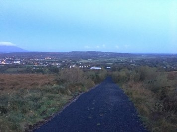
We set out up the N26 and soon turned right after a Mother of Mary shrine on the side of the road. The path began to climb and morning began to break. The climb was a wide, semi-pathed track and it wasn’t long before we reached the top and the path continued rolling across the hills and countryside. It was a chilly but dry morning and we could see we were going to in for a treat with spectacular views over West Ireland.

After a few Km we reached a Lake (Louch Muck) and followed the path to the right passed some beautiful houses with unobstructed views of the lake. The path was again wide and semi-pathed as it led around the lake, into some forests and beyond.
After a little while we reached the N26 again, crossed over and continued up a country road for a little while. We soon encountered our first challenge. As the route led us off the tarmac track and onto some wild and un-maintained tracks. The trail markers reassured us that we were going the right way and we took a moment to enjoy the stunning views as the sun began to shine. We were then presented with a very overgrown route.


The thorns and hedges, soaked with the morning dew, dew reached our knees and thighs and running became almost giraffe like. With high knees. The ground and foliage covered with a white layer of spider webs glistening in the dew. We were slowed to a fast walk. Maybe a km of this path was enough to frustrate us but I was hopeful it was a one-off and just a little used section of the loop.
The route followed some clear track again and we were walking up the road munching on flavoured KitKats when we noticed we were a little off course. Back tracking we found the path again – another overgrown route. We sighed and high-kneed it onward.

We came across another trail fence post with the way markers indicated. But we were momentarily confused as there were two different ways indicated. One across a make shift wooden plank bridge across a stream into a forest, the other straight on behind a tied up rusty cattle gate, into a tree-lined path, shaded from the sun’s reach. The watch said forward and so we climbed the gate and continued.


We soon cane to a halt as I exclaimed “Fuuuuuuck” and stopped. I’d lifted my head and glanced forward and saw, what looked to me like, a little girl, standing there in high-white socks and her long blond hair covering her face and shoulders. Just standing there, silently staring at us and not moving. Nick stopped and swore too as we quickly realised it wasn’t a little spooky girl but a small stumpy pony. As I went to photo it it ran towards us. It ran funny and looked a bit poorly cared for. It loved us and the attention though.
After petting the pony we realised we’d run passed the ‘turn off’. There was no turn though, so I started jogging back to the gate and the pony started chasing after me, excited to play. Nick leaped over the stream and escaped to the forest. I carried on slowly.
As I climbed the gate and headed across the wooden plank bridge Nick acknowledged he was stuck the other side of a farming ‘rope’ fence and another stream. We carried on along our separate sides and the pony ran off and left us. The route was on track, but it was no path and we just stumbled out way through the forest!
The forest looked enchanted and was littered with farming rope as the sun shone through the trees in the distance. The ropes ran both parallel and perpendicular to us and we climbed over and ducked under to continue, Nick to my left navigating his own route. To my right I could hear the ‘tick tick’ clicking of the rope dividers. They were electrified. As I looked up I momentarily freaked myself again as the pony was up ahead galloping (in its own funny way) through the forest towards me. Where and how it arrived I do not know. I petted it more and carried on weaving through the electrified roping. A fence post confirmed the right way but oddly, it didn’t match the route on my watch.

As I climbed over the last rope divider blocking my way, Nick arrived, in style. As he ducked under a rope fence he slipped and became stuck. I laughed as he limbo’d to free his bag from the rope with his feet sliding apart in the mud. The pony didn’t make a sound. As Nick freed himself I warned him about the electric fence. He discarded it claiming it wasn’t and he’d been touching them. To demonstrated this he grabbed the rope and immediately screamed and jumped about. Yep. I was right.
We continued in the direction of the signpost and emerged into a garden, well, field (it’s Ireland!). But the rope dividers continued. The route said we needed to first go diagonally across the land before joining a more prominent path and head left. There was no path across the field though so we walked to the farm building and across the land. I was hesitant knowing this was someone’s property and was glad to climb the boundary wall and hop onto the main path. We sighed some relief and then a dog came.
It was an old dog. Wheezing. Not barking. It wanted attention. So much attention, sitting on our feet. It moaned and wheezed and pushed against us when we tried to continue. Then it barked a loud screechy wheezy bark and wouldn’t shut up. We ran on. I looked back as we ran and saw a figure behind us standing on the track and watching us run away. It was some form of ‘heritage centre’ (‘Hennigan’s Heritage Centre’) but seemed almost abandoned and lacking any Heritage (to a passer by!). Either way, a little freaked out by the figure and conscious our trail through the ‘enchanted’ forest had cost us some time we ran fast along a country lane whilst many more aggressive dogs barked from within their fenced gardens. Thankfully unable to get at us!

After a short incline the path again indicated a turn to the right and the start of the second highest climb of our run. Again, despite the sign posting, the path was not feasible. Overgrown and thorny to at least waist height. We couldn’t go up it so instead we climbed a wall into the field running alongside, cautiously acknowledging the sign saying “beware, bull in field”.
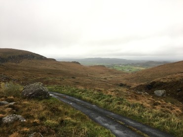
We stuck as close to the path as best we could but it was far easier to walk parallel to it in the field. Whilst we would have needed a machete to navigate the path, we instead had to navigate lumpy boggy fields as we hiked to the top. Our feet were already wet but now so too we’re our legs from the knees down. There was no way to avoid the bogs.


As we traced alongside the wall ‘up’ we contended with the water-logged bogs and lumpy divets. The climb was slow but we kept going, occasionally turning around to absorb the views behind us. The higher we climbed, the worse it became though and we’d occasionally go right back to the overgrown track to confirm the directions.
Eventually we reached a wall by some old ruins and climbed over onto the most mainstream of roads we’d seen for quite some time (still a country lane). We turned right and ran on. We came upon a collection of houses and ran passed another trail marking. It indicated the path would turn left sooner than the map on my watch indicated. Whilst I went ahead and checked it out, Nick made a new friend. Another dog, black and shaggy (like ol’ wheezy’ only much younger’). I came back as the point the watch was suggesting was far less accessible than the area indicated by the trail sign.
We spent a few moments petting the dog which was silent and attentive with these big dark brown eyes that pierced you. We decided to trust the sign post best and climbed a wall to get onto the indicated route. We were back up to our knees in foliage yet again. Then we weren’t alone. The dog had come with us. He bounded through the wet grasses and stopped up ahead as if showing us the way.

We kept trying to send he dog back but it wouldn’t. I was glad of the dog at this point. The route again was not clear and the dog became the marker. It was like he knew the way we needed to go and was helping to guide us. It was a little surreal but a huge insight to a dog’s mind. I believed it was telling us to follow him.
We continued on like his for the whole climb. A long climb. As we reached the top, soaked through from the waist down, we again tried to send the dog back. Sam, we called it Sam, was having none of it. So on we continued together. Again, I was thankful as we began to descend the hill as it was all off track and lumpy and muddy. The track was not clear or available at all. But Sam saw a way through and we followed. The last part of the climb was through a field covered and glistening with webs. Sam bounded through without a care in the world.

After what felt like ages of climbing and descending we reached a wide drive-able track. We tried to run on and recoup some time. As we struck a rhythm we turned left onto a slightly less mainstream track, still runnable though. We tried once more to ditch Sam. We failed. I looked back and saw the mountain (hill really) behind us becoming a distant shadow. I worried Sam wouldn’t get back. Nick was thinking the same and despite my protests was already planning how we’d return the dog. Whilst I was trying to put us first, I knew he was right – We had to get Sam home safely after the run.
The path opened into a small area of houses and buildings. Many being built. Many not looking that nice. A community. There were lots of dogs. Some looked aggressive. Some barked and began chase. Sam wasn’t phased. No comment. No sound. Just ran on ahead, guiding his “humans”. We were glad to get away from that area and all the dogs.
We hit a stream and whilst Sam refreshed we untied an old pallet crate makeshift fence and continued. I thought we’d lose him here, but to my surprise, Sam figured a way around and continue with us. At that point I accepted he be staying with us.
The path was over grown and we climbed gradually with the boggy, unclear track. Then a house. It felt once more like we were on someone’s land, but up ahead some metal steps had been built over the stone wall to guide the way. Once over, Sam was there looking at us wondering what went wrong and why we’d taken so long. Onward we went, to the right we climbed. A little more. Always a little more.

The track opened and we ran down. A nice section of wide trail paths that was very runnable. The views were beautiful. Sam up ahead. Every few hundred metres he was turning around and looking to see if we were following. At the bottom the biggest climb was about to begin. Now the green steps over the walls were marking the way. We went over, Sam went around. The route again was overgrown. My feet we’re wet and cold. My legs scratched to shit from all the brambles. We were embracing it though. Up and over this ‘mountain’. 200m. A baby. Head down and march on. Sam, diligently as ever kept stopping and waiting. Or running back and sitting at our feet. Eyes wide open, want a pat on the head. I desperately wanted to feed and water him but my fuel for the day was High5 isotonics and KitKats – not dog friendly!!
Eventually we reached the top and stopped to take pictures. Sam was all over this. Jumping on the rocks to join us and pose. A well deserved break and a moment to enjoy what the run has amounted too. A really off road adventure and a new friend too!


With time on our mind we cracked on. We now had less time than we’d planned. Whilst the run has taken longer than planned (with wrong turns, animal encounters and navigating around the unfeasible paths we’d added about 30 mins to our conservative estimate) we now had to taxi our new friend home also. We had no idea how long this might take but we knew we couldn’t abandon him now. He hadn’t left us for a close to two hours at this point. We picked up the pace and began to ran. Soon we were walking again though – the descent was very boggy and we were slipping all over the place.

Eventually we reached a pathed track and recognised the area from the previous day’s run. We knew where we were now. Soon the main road appeared and we had to control Sam as we crossed and ran a short distance along the country lanes with cars zipping passed.
Taking side roads Sam started to attract attention from more dogs (did everyone own dogs in this part of Ireland?!?) and took a particular shine to a dog being carried by two girls. Like a ‘dutiful owner’ I had to go back and drag Sam away. Whilst they were OK with the encounter, Sam didn’t look too impressed with me!
The final straight soon appeared and we knew we just had to run to the end of the road. One more obstacle though – the road was closed. Fenced off for building works. Bollocks. It was a bit of a trek back to circumnavigate around the road works so we made the decision to climb around the fencing, coaxing Sam to join us. We ran through the closed road, passed the Wollen Mill and arrived back where we started.
We realised we’d left the car unlocked (with all our stuff in it) and as soon as we popped the boot Sam jumped in. He didn’t stay long before leaping back out and seemingly wanted to play with the traffic instead, refusing to get back in until Nick picked him up. How he had so much energy left I don’t know – Sam ran with us for 18km and some 2.5 hrs!
Where he Ra


Nick started driving while I sat in back Sync-ing the activity from my watch and looking for where I thought we picked Sam up. Thankfully the unclear trail turning and climb were giveaways and I found where I paced up and down looking for the path and where we zigzagged up the mountain following Sam. Found it! 5 miles later we were at the houses where we met Sam, near a place called Cornageltha. We picked the house we thought he appeared from and Nick knocked on the door…

A little old lady came out, confirmed Sam was hers and laughed when she saw him sitting in the car. We let Sam out and he sat at my feet whilst we talked to the lady. She told us his name was Rocky. She explained he always goes off with strangers and walkers and that neighbours normally call her when he is found and that her brother has to go out and collect him from wherever he has decided to stop. She thanked us for looking after him and bringing him home. He jumped up and hugged us as we said good bye. We got into the car and made to leave.

As we left I overheard her talking to Rocky. She said something along the lines of “why do you always do this” pleading with him not to keep running off with strangers. “what will I do without you”. She questioned. I almost cried…

Trail Notes / Directions (Anti-Clockwise Loop)
The route – Foxford Way Loop

We used http://www.mayowalks.ie to identify the loop and a visual representative from http://www.mayowalks.ie/media/Media,14140,en.pdf. A more detailed route can be found on Open Street Map – https://www.openstreetmap.org/relation/2859131.
The Foxford Way Loop is described as “a 33km long route, with the Ox Mountains on one side and the Nephin Mountain on the other; it is one of Mayo’s finest walks. Along the route a rich rich variety of flora and fauna and an exceptional archaeological and historical content is to be expected.” The terrain of the route will include bogs (wish we’d paid attention to that before hand!), mountains, rivers and lakes and breath-taking scenery to delight. This we can vouch for!
We decided to do the Loop in an anti-clockwise direction, although there seems to be no guidance as to the benefits of doing the loop in either orientation.
The Start / Finish – Foxford
Whilst http://www.mayowalks.ie describes the official start/finish point as being located in Foxford “beside the children’s playground in a car park just off the N26” we found this a little vague. So we parked up and started/finished on the N26 outside the ‘Centra’ shop, right in the middle of Foxford near the Wollen Mill.
We’ve split the trail notes into a few sections to provide guidance for anyone wanting to follow the route.
Section 1 – “Lough Muck” (Foxford to Lismorane). Distance from Start approx. 5.6 miles
From the Start in Foxford, the first section loops South from the N26, around Lough Muck before re-joining and crossing the N26 again just passed Lismorane.
From the Centra we headed East along the N26 in the direction of Swinford. The initial route ran alongside the N26 for about 0.8 of a mile. There is no pavement nor path for the majority of this section and we ran along the dotted lined/verge of the road. The turn off the N26 (on the right hand side of the road) was just after a religious shrine/monument and opposite “Noorey Park” road.
The trail here was wide and semi-pathed. It initially climbs to a height of about 400ft alongside the peak of Carranarah. The path continues in a South-Easterly direction from the N26 for about 1.5 miles before reaching Lough Much. From here the Trail continues South then in an Easterly direction (about 3.5 miles) until it reaches the N26 again. This whole section was well signposted with undulating trails. Easy to walk and run for all abilities.
Section 2 – “Cornageltha” N26 (Lismorane) to Cornageltha. Distance from Start approx. 11.2 miles
When the trail meets the N26 again just passed Lismorane, follow the N26 in an Eastern direction (again towards Swinford). Again, there is no pavement along this section of a busy road. Take the first left onto the ‘unnamed’ road after about 0.3 miles along the N26.
Follow the pathed road for about 0.5 miles (gradual incline) and turn right at the intersection. After about 0.7 miles of semi-pathed, down hill track, turn left. This section is single track and very un-maintained. The foliage was overgrown at waist height, the ground very lumpy and soft underfoot. The path continues like this for approximately one mile, emerging onto a small country road labelled “Graffy” in a North-Westerly direction.
Take the first right turn after about 0.2 miles along the Graffy. There should, almost immediately, be a trail heading off to the left of the path. This is signposted by the Yellow arrow/Hiker. Again this path is un-maintained and a little difficult to spot.
After about 0.3 miles the trail splits. There are two signs marked for the route, one straight beyond a closed and tied rusty farm gate, the other to the right across a small stream into a forest. Both probably lead to the same way, but the route to the right through the forest seems a better choice, if not a little ‘off-piste’. The forest is marked with electrified cattle rope and at the end you can see the yellow route / trail marker.
The route emerges from the forest into the fields/grounds of the Hennigan’s Heritage Centre. Leave the grounds and join the road ‘Rubble’. After approximately 0.5 miles, turn left at the road intersection onto Tiernunny. Follow the country road for 1 mile and then turn ‘Right’, shortly after the village of Derrynamuch, at the trail marker.
The section here is approximately 0.5 miles long. The official route indicates you should climb approximately 200ft along a marked route lined by a wall. You can see the route, however it is completely un-maintained and overgrown with brambles and (as of Oct 2019) not feasible to navigate along. We climbed a small, waist high, wall into the field (noting the sign warning “Beware of Bull” and made the climb through the field alongside the overgrown path. Whilst the field is easy to navigate (just keep heading ‘up’) it is very ‘lump’ and full of stream water and boggy. The Bogs in some places were knee height.
At the top of the climb you join the country road “Carrownedin” (just east of the village of Cornageltha) and head to the right/East for about 0.5 miles until you reach a small collection of houses on your right hand side and fields on your left. There should be a Trail marker/signpost indicating the route continues through the fields on the left.
Section 3 – “Carha” Cornageltha to Carha. Distance from Start approx. 17.5 miles
Cross/climb the stone wall into the fields inline with the trail marker. Whilst the path is not obvious and the fields are overgrown to about shin height with long grass, the way is clear – straight up!
Stick to the right-hand side of the field you start in and follow it for about 0.5 miles to a highest point of about 700ft. Be sure to look around and enjoy the views on this climb! There are 3 or 4 trail posts dotted along the climb that are visible and will aid directions.
When you reach the highest point, you should see a drop ahead towards a country road and a lake in the North-West direction. Again the way down is not particularly clear but you can see a feint boggy track leading down towards the country road and a few more trail markers will help reach it safely.
Once you reach the road the next part is easily navigated – Follow the ‘un-named’ road North and it will soon split. Take the left/West track and stick to it. The track here is semi-pathed and wide.
After a little more than 1.5 miles you’ll reach a (skewed) crossroad. Continue straight across (West direction) for another mile before reaching an intersection and turning left towards the village of ‘Muckroe’.
The trail markers will soon be visible, and you’ll take a left turn off the country road back onto single track trails. From here the route climbs to its highest point of approximately 830ft. The path is clearly navigated, first through boggy fields with occasional green metal step ladders to enter/exit the fields. After the field section the route continues up the climb through open countryside. Again trail markers are occasionally visible to navigate by. After about 1 mile of climbing you’ll reach the summit.
From here the path down towards Carha is visible and clear. Easy to follow with occasional trail markers the whole way. It is very ‘lump’ soft ground with plenty of bogs to enjoy.
After another mile and descending approximately 500ft you’ll reach a country lane (again not labelled) and turn left towards Carha about 0.3 miles away.
Section 4 – “Home stretch” Carha to Foxford distance approx. 21.8 miles
As you reach Carha, take the first left, continuing on the same unnamed country lane. Follow this lane for about 1.5 miles due South-West. You’ll reach an intersection of a main road (which runs parallel to the N26). Cross the road and keep left, taking the split of the road which heads further South-West towards the River Moy.
After 1 mile turn Right towards the village of Rinnaney. Follow the road left through the village then take the first right. After 0.3 miles turn left onto Green Road.
Follow Green road for just over a mile along the River Moy as it becomes Lower Main Street. Here you will pass the Foxford Wollen Mill, Leisure Centre and return to the N26 Swinford Road where it all started.

One thought on “The Enchanted Adventure”