Never trust Italians 

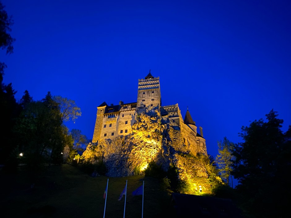
Here we go then. The first ‘big one’ and real ultra test of 2025 – the Dolomiti Extreme Trail. 103km of trail running around the beautiful Dolomites. It wouldn’t be my first running adventure in the Dolomites – back in 2019 I ran the Lavaredo Ultra Trail – so when Matt messaged about joining him for the race, part of me thought ‘oh I’ve been there and done that’ but after looking into it I realised the race is in a completely different part of the region. So I was in, ready to explore some more of the beautiful Dolomites. 

Leading up to the race, the organisation seemed top notch. There was a plethora of information provided and heaps of services for runners. For example, being in a small town, many runners would be staying in other parts of the valley and a bus service to transport you around, between registration and hotels and to and from the start and finish was provided. This would be great…

We were staying a little further up in the valley in Mareson and I flew in the night before Matt and stayed overnight near the airport in Venice. We rented a car and drove over the day before the race. We checked in to the hotel and were all set to use the bus service to head down and register. The hotel even called the organisers and confirmed the bus schedule for us. We hung around and waited for a bus that never came. The hotel owner’s son very kindly drove us down to the Forno di Zoldo to register. After registering we checked and asked about the buses (and also ‘booked’ our bus back to the town for the start the next evening) and were told ‘oh, the buses aren’t running today’. Despite them being advertised and the schedules being provided to all the hotels and confirmed over the phone a few hours earlier… this was frustrating. It also seemed unclear whether we’d be able to get a bus back in the early hours of Sunday morning when we were likely to finish. But that was a problem for two days time. As we left to find our own way back up the valley, It was at this moment we joked ‘Never trust Italians’. The phrase held true for the whole weekend…

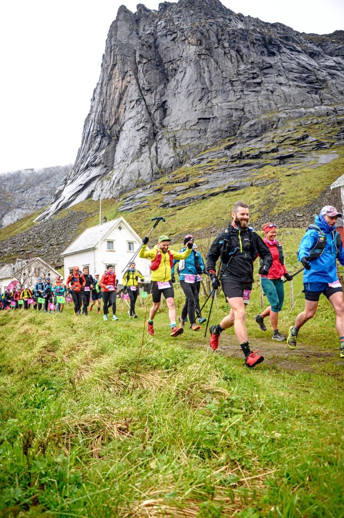
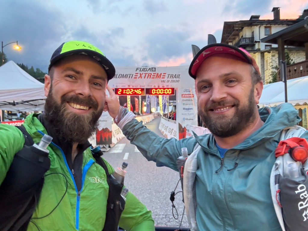
Friday evening we were making our way down to the start line when we were talking to the hotel owner’s son again. He wished us well and said he’d be volunteering at a checkpoint. We didn’t recognise the checkpoint name and after a little discussion it became apparent from him that we’d be doing an alternate route due to high snow levels on the summit. We hadn’t been told this… he also mentioned that 8 out of the 10 years of the event the alternate route had been run (sounds like it is the main route rather than the alternate!). At the start line we confirmed and clarified this with someone from the organisation. With appropriate mental adjustments and re-calculations made, we were set. We left our drop bags off at the dedicated zone and waited for the race to begin. A little while later in the start pen, just a few moments before the race began, there was a medical emergency for a runner and the start was delayed whilst they received medical attention. Then, a little after 10pm we began…

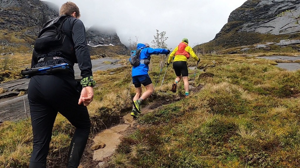
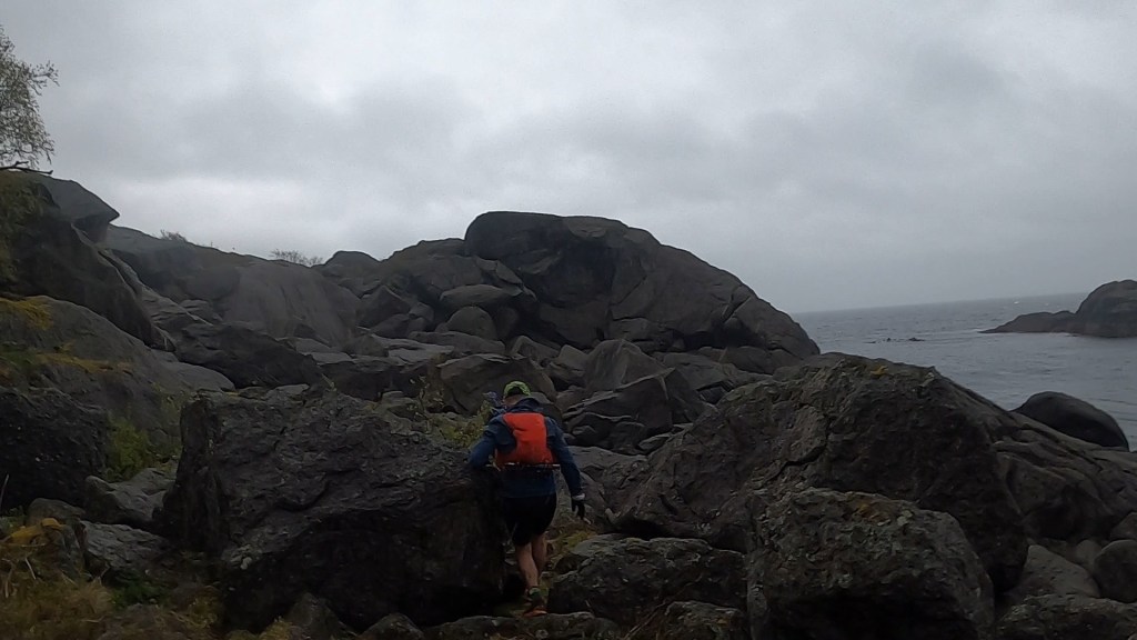
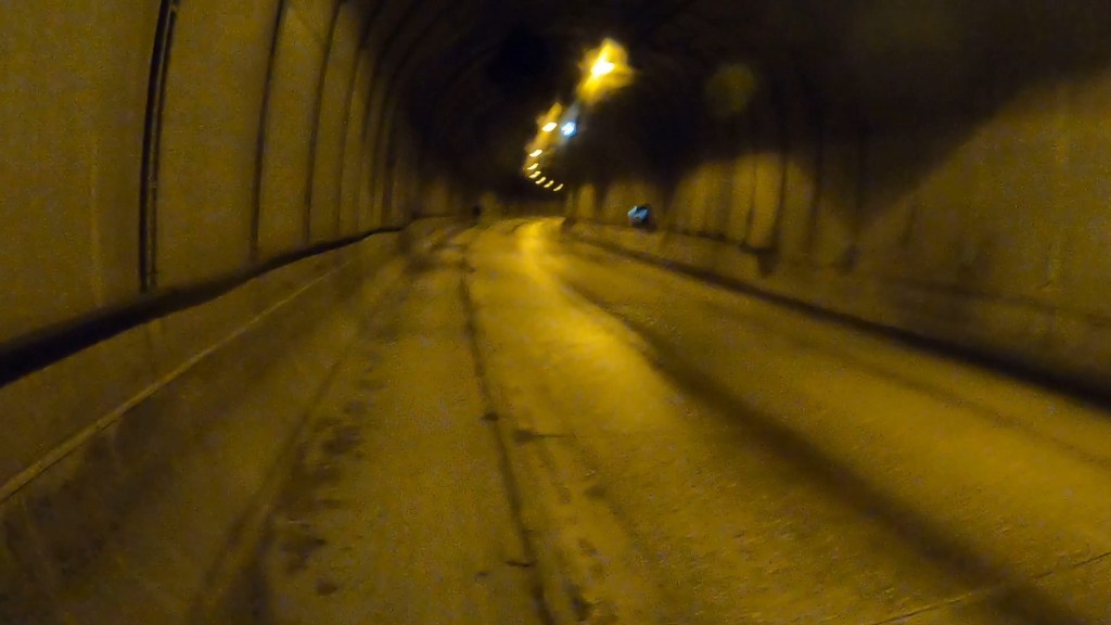
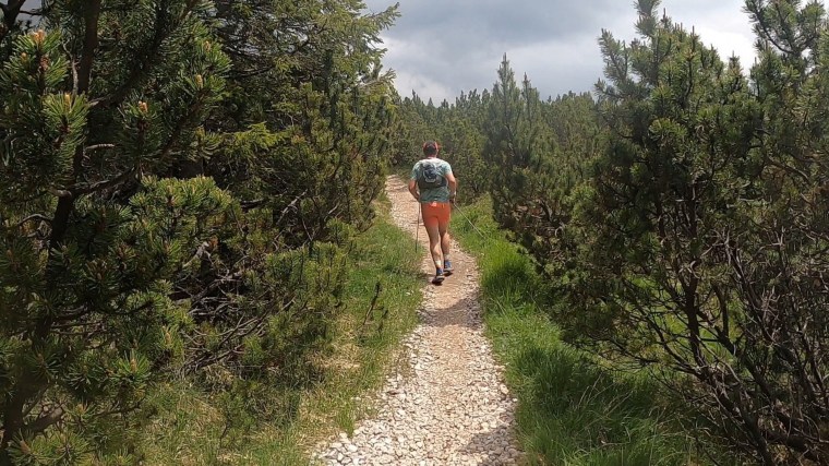
The race began quite quickly. 100s of runners running fast down the wide main road. A gradual decline, the pace was excessive for the first few kms of a 100km mountain race. We were caught up in the moment trying to maintain our place in the pack. We ran down and through the tunnel we drove in through on the way in the day before. The tunnel seemed so much longer on foot! Leaving the tunnel we left the road and hit the trails at Le Bocole. Loads of runners stopped to ‘water’ the piles of gravel and aggregate. Then we had the greatest ever bit of support from a local (I assume) as they rev’d a chainsaw above their head in the darkness of the night “Vrrr Vrrr Vrrr”. It was different and made us laugh and a real talking point!

Legging it down the road

My memory of the course was a long single track climb that lead to a real dense forest where it was very soft underfoot. The floor was covered with pine needles and bounced and wobbled under our weight. Through the forest we climbed higher and higher in the humid night. It was hot and stuffy. Very hot. Somewhere the trails opened up and we had some enjoyable runnable descending for several kms mixed with a few short technical descents and bottlenecks at each. One technical section had quite a pile up as runners had to cross a fast moving river. Volunteers lit up the river with massive fires and helped ensure we all crossed safely. 

The other side of the river led us back up a very steep long climb and back into the humidity of the night. The forests around us smelt so fresh and the night was so peaceful despite the sounds of runners huffing and puffing their way upwards. Once more what went up must come down and so we did once again on an enjoyable descent that was a joy to run down. It lead to the first aid station, a water only stop where we quickly refilled and moved on. 

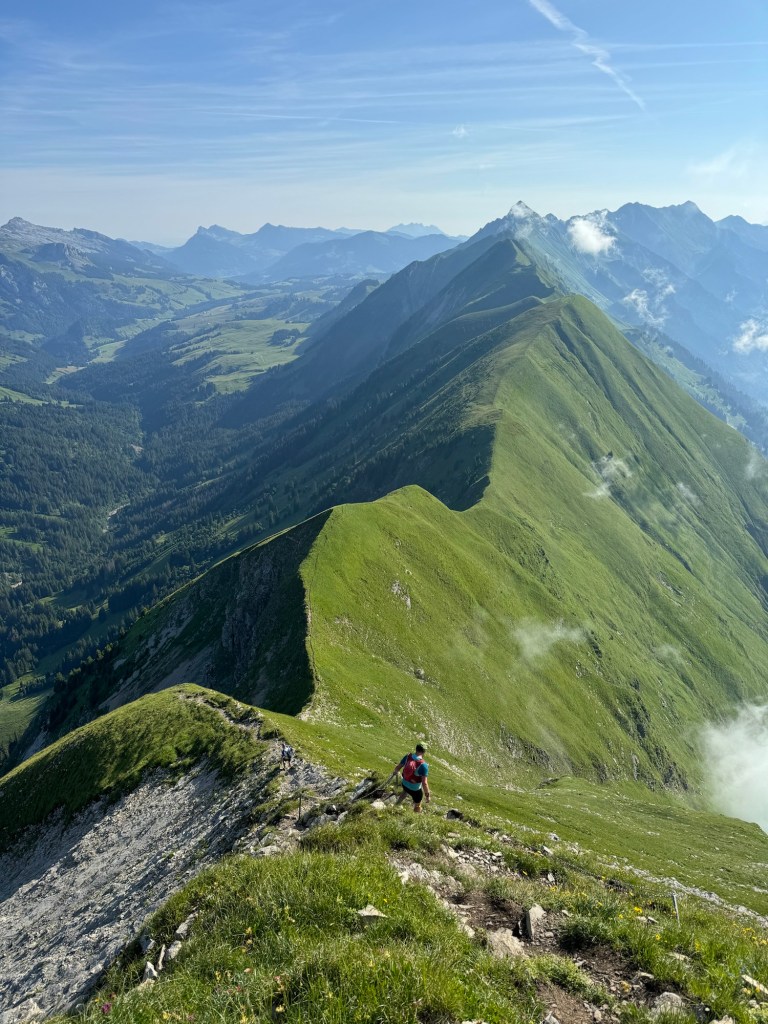
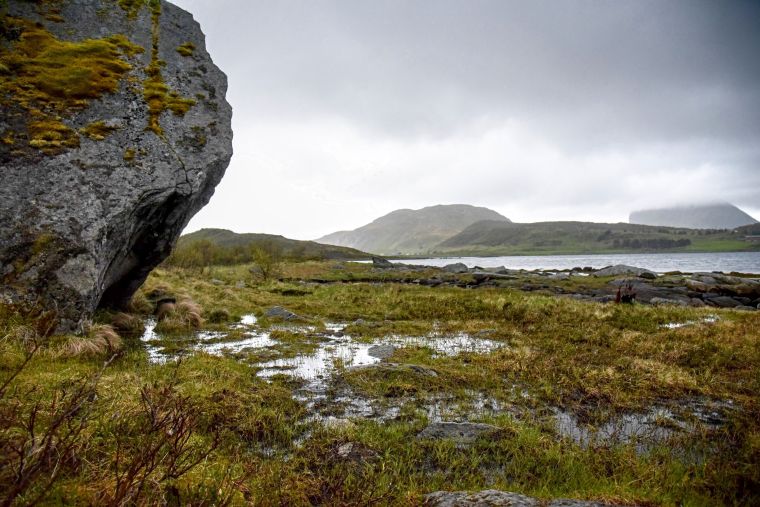
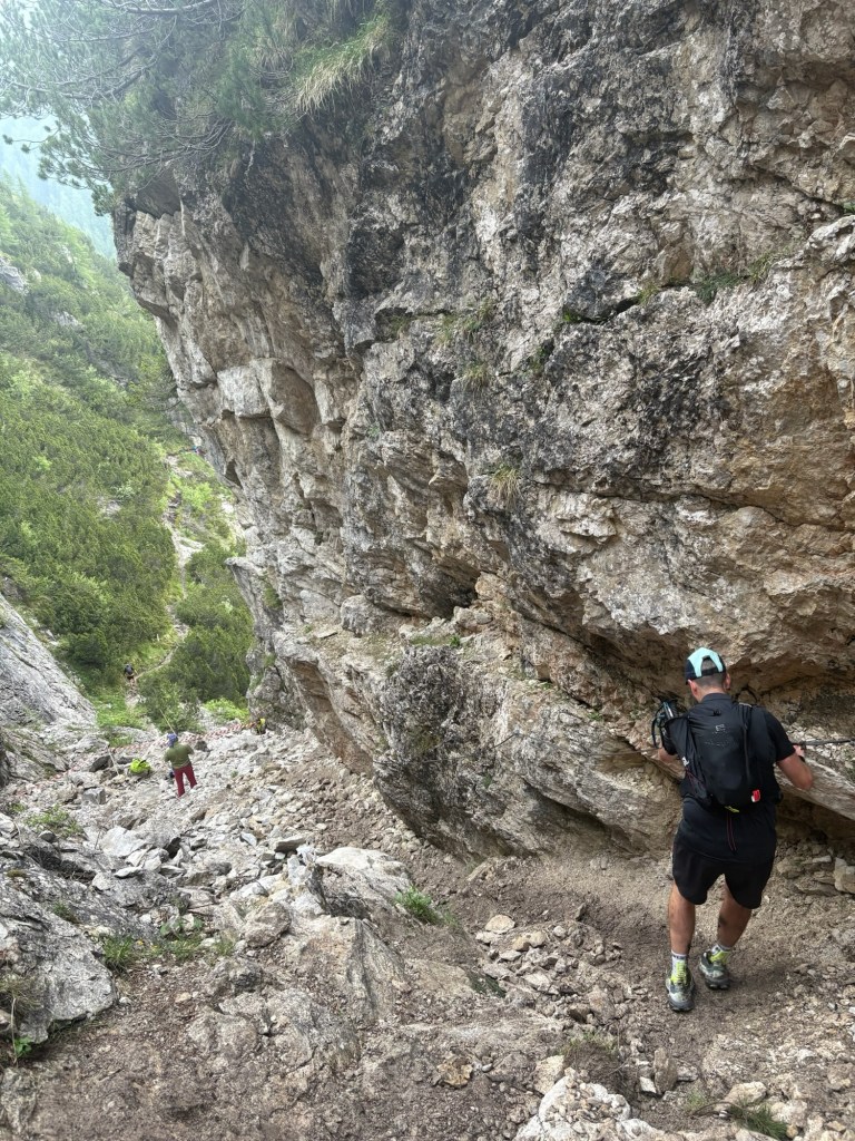
Looking back, this first section was probably one of the easier bits of the course but also gave the first insight into the route. Throughout, and what followed was long and steep, very steep climbs. Each one caught us out and we moved slowly. The terrain however changed and the ground became softer and wetter and harder to move through. A few days of relentless rain and storms had saturated the mountains and made them far muddier than I was expecting. Our pace on the climbs dropped as we moved more slowly. The descents too became rockier and more technical. Gone were the lovely runnable descents we’d first encountered. 

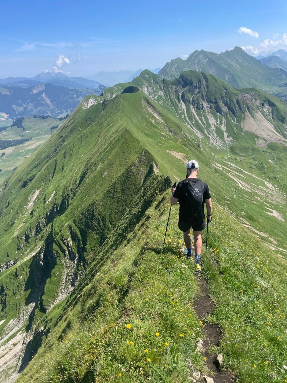
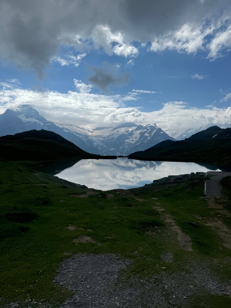
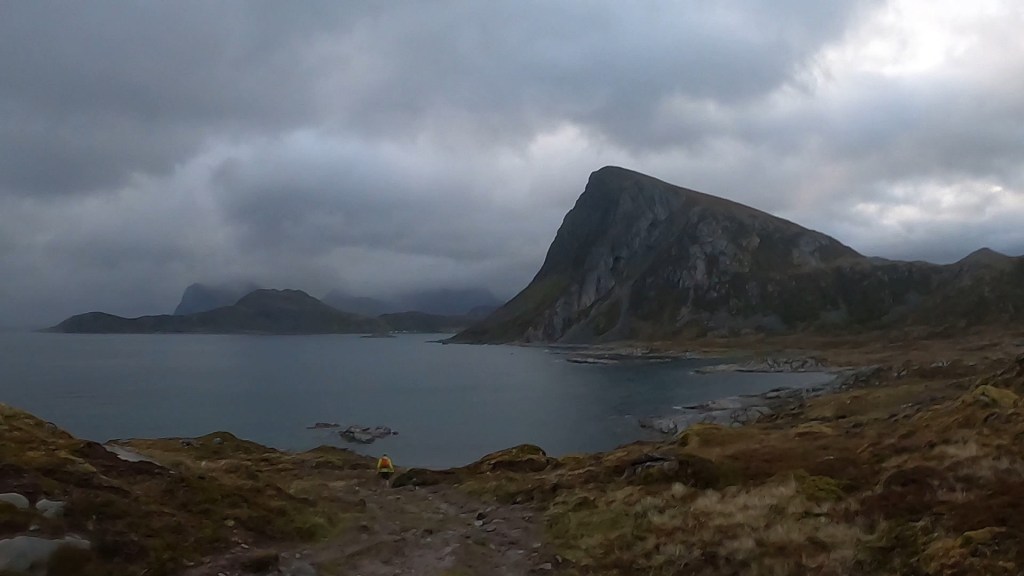
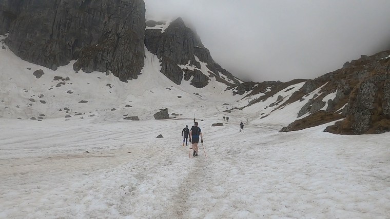
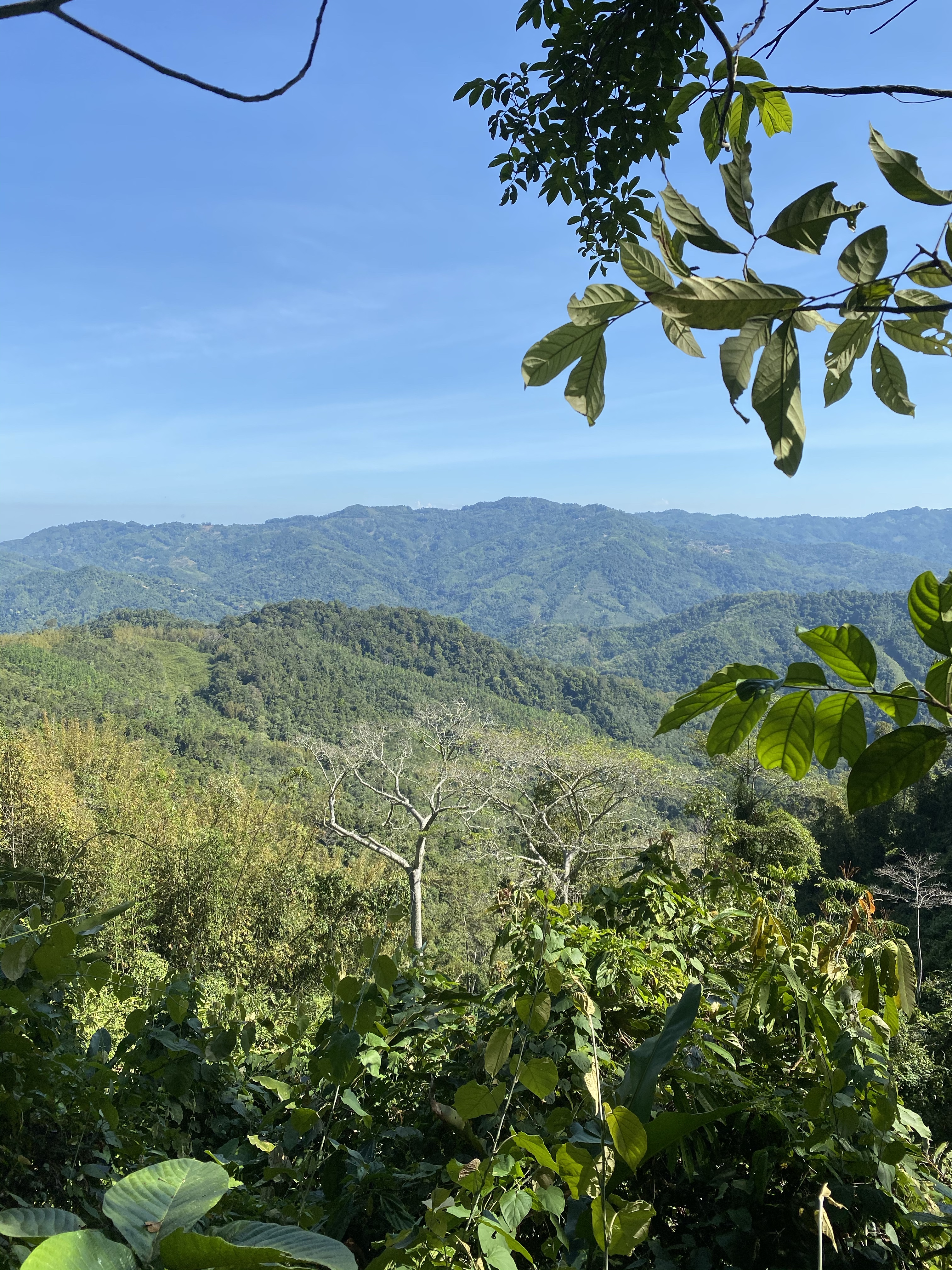
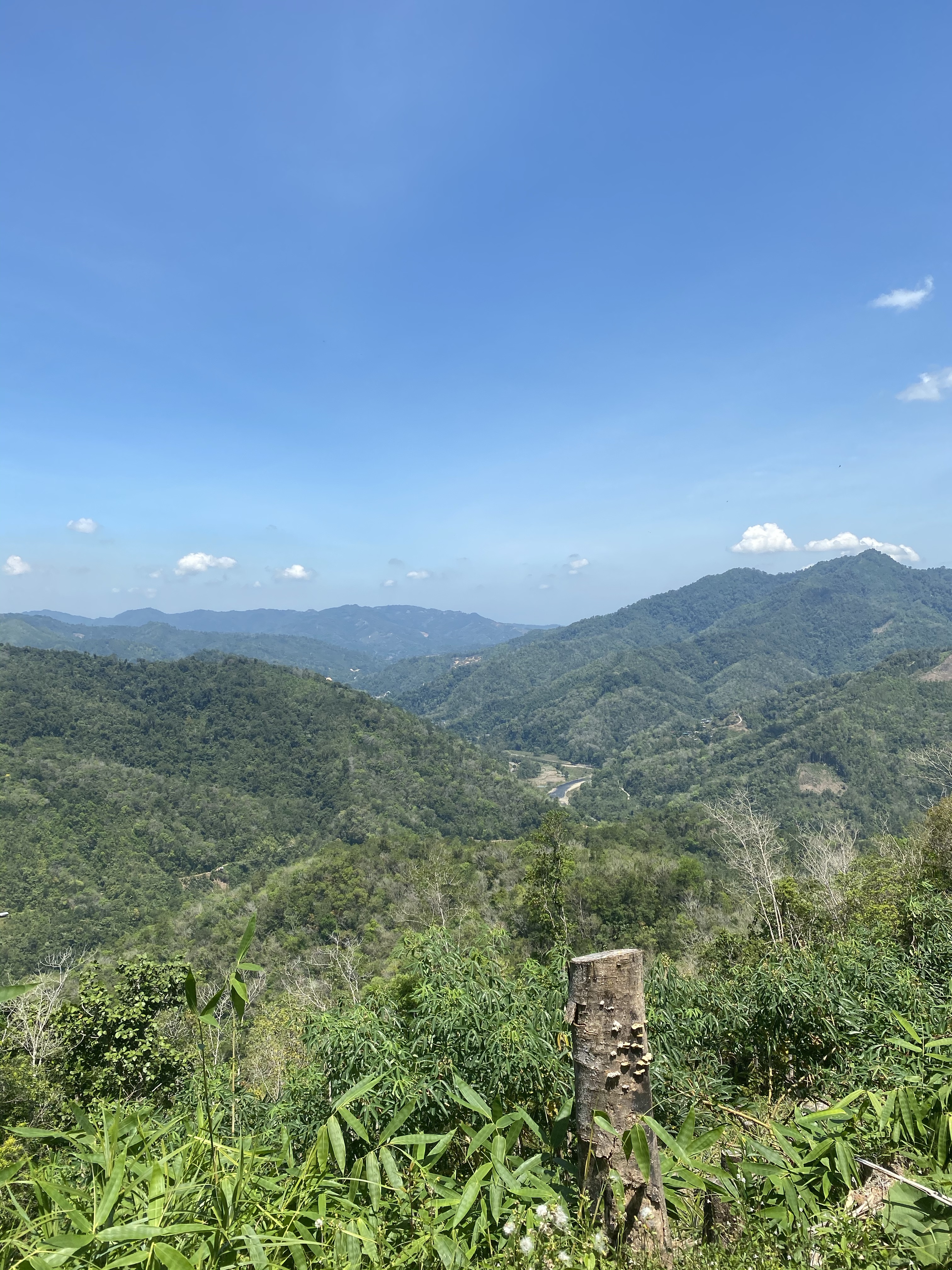
As we continued the theme of the night became persistent. It was hot, very hot, yet we were very cold with the sweat of the humid night and gentle breeze. When the mud subsided, it gave way to big rocky sections and boulders to climb up. The combination was exhausting. We ran through forests, passed lakes and broke out into lightly coated snowy trails on the side of the mountains. Despite the steep climbs, we weren’t hitting summits and were skirting around the side of them. As we descended back into forests the day light started to break through the darkness and we could see the shape of the magnificent landscape around us. It was early in the morning and the birds were bringing the music and soundtrack to the trails. 

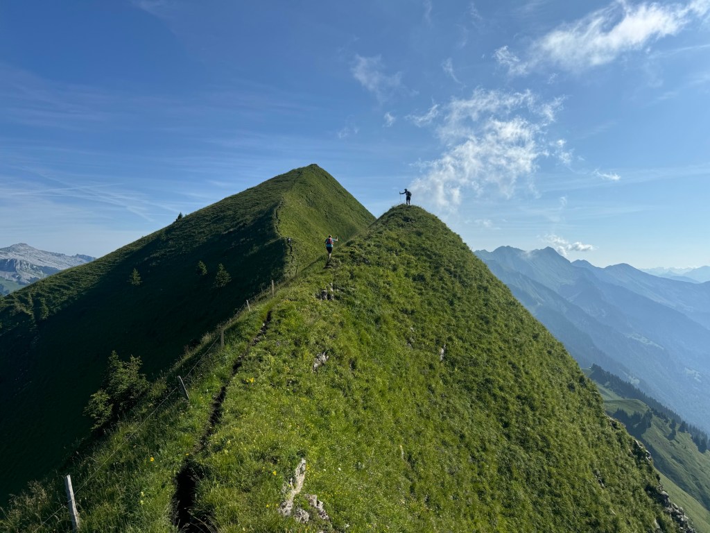
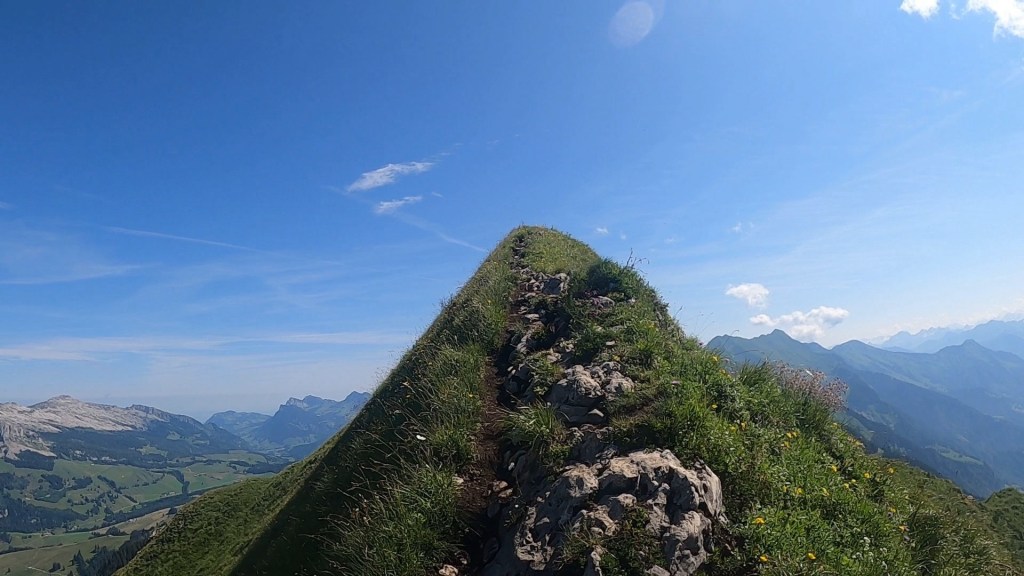
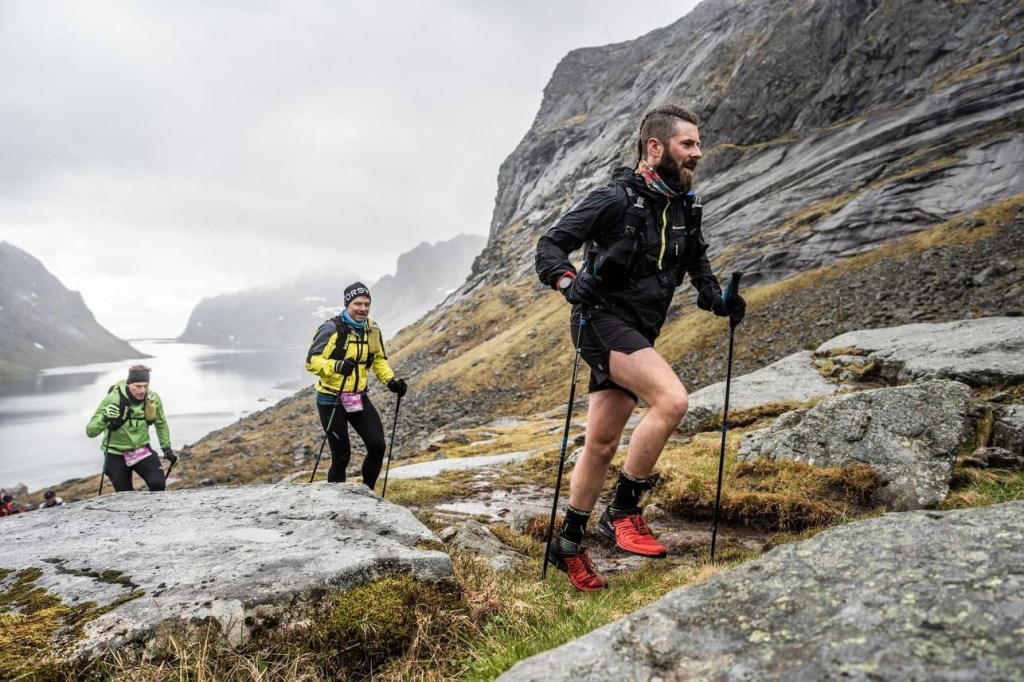
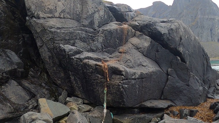
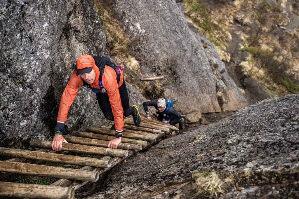
Reminiscing, the trails of the first 50km have all blurred into a series of tough climbs, muddy trails and rocky technical sections. At one point there was a particularly technical descent with a safety rope/chain. Runners were tentatively making our way down when the lead runner of the 50km zipped passed. He flew down, barely touching the ground. No chain or support, no fear. He descended effortlessly and out of sight in the time it took me to cover a few meters of the descent.  It was so impressive. 

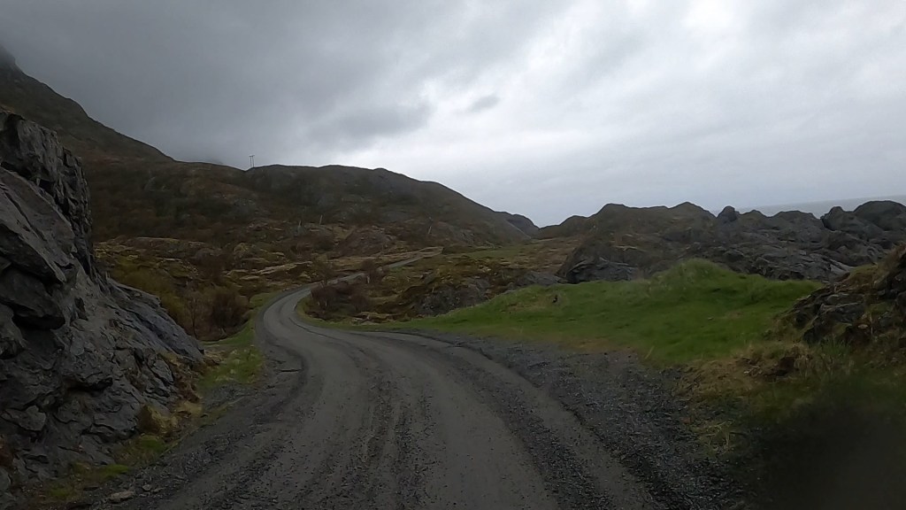
After a few aid stations it became apparent that the information on the distances and tracks between them was a bit… iffy…  some aid stations would come around far quicker than expected one was even 3 or 4kms earlier than we thought. We stayed high for a while and had some pathed road sections that climbed between aid stations. After one we could see runners far off ahead going up a ski track. Soon we followed. It was short but steep. Naturally after a while we had to drop the equivalent on a steep descent down. 

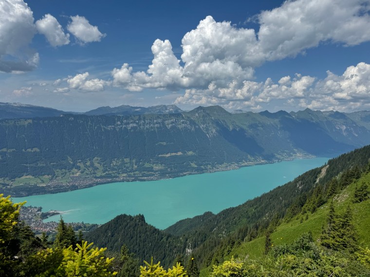
By now it was close to midday. The temperature had soared and the humidity persisted. I was looking forward to a change into dry clothes and tending to my ‘personal’ needs at the half way mark. It wasn’t long before we were making our way to the half way mark where we’d have our drop bags. It was at a refuge we’d visited in the car the day before. We recognised the trails and we happy to arrive. 

The aid station was chaotic. A big marquee was full of runners from the 100km, the 70km and the 50km. Supporters and families of the runners filled the tent and we struggled to find a place to sit down and make space for ourselves. We bunched some others up on a table and also identified a volunteer who was sorting the drop bags. We gave her our numbers and she said she’d get our bags and bring them to the table for us. Great. But this is where things went a bit rogue. Remember, never trust and Italian!

As we set about our ‘break’, we were a bit deflated by the lack of hot food or variation to food at the aid station and settled in for some more of the very bland and tasteless ‘soup’ with some small bits of noodles which had been available at most aid stations. It was by far the worse ‘soup’ I’ve had at a race. We stripped off our wet clothes and sat topless in our pants, sweating away in the busy tent. Time was passing by and we still didn’t have our drop bags. We had to ask again 3 or 4 times over the course of about 20 minutes. The woman kept saying they were coming, she also came a few times to re- ask our numbers. It was irritating. Eventually Matt’s bag showed up. But mine didn’t. God knows how much more time had passed when she started bringing other people’s bags to me. It didn’t make sense. Finally she told me they couldn’t find my bag and to put my shirt on and go look for it myself. Not what I wanted to be doing…

Annoyingly the drop bags were located a little distance away from the marquee. And this is where I could see the problem. It was essentially a human chain, like ‘Chinese whispers’. Volunteers passing numbers verbally between them. Then telling kids who’d run off and collect the bag and return it. No wonder she was bringing the wrong numbers and having to keep asking what was our number. It was just chaotic confusion! 

At the bag location the volunteers all spoke little English. One German lady was very helpful and also very traumatised that they couldn’t find my bag. Sadly, regrettably, she was getting the blunt end of my frustration. She was explaining that they didn’t know where my bag was, and suspected it had been sent to the finish line. I could see the pain she was experiencing as her ‘system’ had failed and she couldn’t explain or account for why my bag was there. My issue though was that it was all guesses. I wanted clarity, if they could confirm where my bag was, my mind would be at ease. With a late night finish expected, and an early wake up to drive to the airport, I wouldn’t have the time to go looking for my bag the next day. It took a bit of persuasion from me to get get them to call the finish line and look for my bag. The lady also roped her husband in to translate as he spoke more English (and I spoke no German nor Italian!). This was helpful as the volunteers were planning on getting my bag brought back to the aid station if they found it at the finish! Through him I was able to express that this was not going to be helpful – I was cold from the wet clothes and needed to get moving again. I didn’t have the time to wait for the bag to be found and driven back up the mountain!

I went back to eating and waited a little longer whilst they tried to confirm where my bag was. The man kept providing me updates – it wasn’t at the finish line either, so they suspected it was now in a van on the way to the finish – but it got to the point where we had to leave. We’d been at the aid station for over an hour now. As we left, crossed the road back to the trails, the man came running after us. They’d found the bag, confirmed it was in the van and now at the finish line waiting. I thanked him. At least my mind was at ease now knowing where my bag was.

Despite knowing though, my mind had ‘gone’. For God knows how long I moaned about the experience. Much to Matt’s annoyance, I couldn’t let it go. I moaned endlessly about how it shouldn’t happen, the process had failed, what I didn’t have (my preferred hydration/personal effects etc.), that every runner I recognised that we ran near had changed into fresh clothes and I hadn’t… everything. I just moaned. I made bold statements about the harsh words I’d have with the race organisers at the finish, the regret I had for the frustrated tone I’d spoke to the very helpful lady with etc. for kms after the aid station and throughout the next 50km I moaned and moaned and moaned.

The only flipside was it lit a bit of a fire in me. I was very uncomfortable with chafe, wet itch clothes and worrying about how my energy levels would drop as I’d now be reliant on the horrible soup and weak isotonic drinks at the aid station, so I was pushing us an moving quicker with the single aim of getting it over with as soon as possible. Matt occasionally would have to reign me in and stop me from burning us both out, we did have plenty of time after all!

This first section of the second half the race was a long 11km stretch between aid stations. It was mostly the very familiar gradual climbs through woodlands and dense forests and long dirt gravel tracks. In our minds we would have a course split around this point and no longer have the masses of 70km and 50km runners with us. But our understanding of the course was off and we were ‘in with the masses’ for far longer than we expected. This made the trails busy and frustrating. There was a very long descend on the same terrain down into the next aid station which was in another town in the many valleys of the area. Matt saw an opportunity to visit the town hall and I waited for him at the aid station a little further along the main road. Here I had the cheekiest reminder of my bag drop situation. A volunteer saw my number and said “ahhh, you are the runner who didn’t get your bag / are waiting for your bag”. I said “yes, that is me!”. To which they politely but bluntly stated it wasn’t here either. I had to laugh. It was meant in the most helpful and supportive way, but with the language barrier it came like a slap to the face. Almost like hey you, guess what… I was able to see the funny side of this interaction at least.

After a short break we moved on. We were straight onto a pathed road. It was pretty much following this road for about 5km to the next aid station. Whilst not particularly scenic or enjoyable, the road did bring a bit of a change to the terrain and relieved a bit of the pressure on the feet and ankles which were now very sore and blistering.

At the next aid station we arrived to a mountain hut to the biggest welcome from the Lady running it. In broken English she reeled off all the things she could give us, including “Meat Soup”. She couldn’t understand our excitement when we repeated and clarified that she had soup with meat in it. She was saying everyone was reacting the same and she didn’t know why. We tried to explain how everywhere else the soup was terrible and even the thought of something more substantial was a blessing. Matt took one look at the meat and changed his mind (he did get a coffee, albeit a terrible one, it was the only aid station of the race that had hot drinks!). I took extra meat and enjoyed it with other runners like it was a last supper!

Steep climb ahead

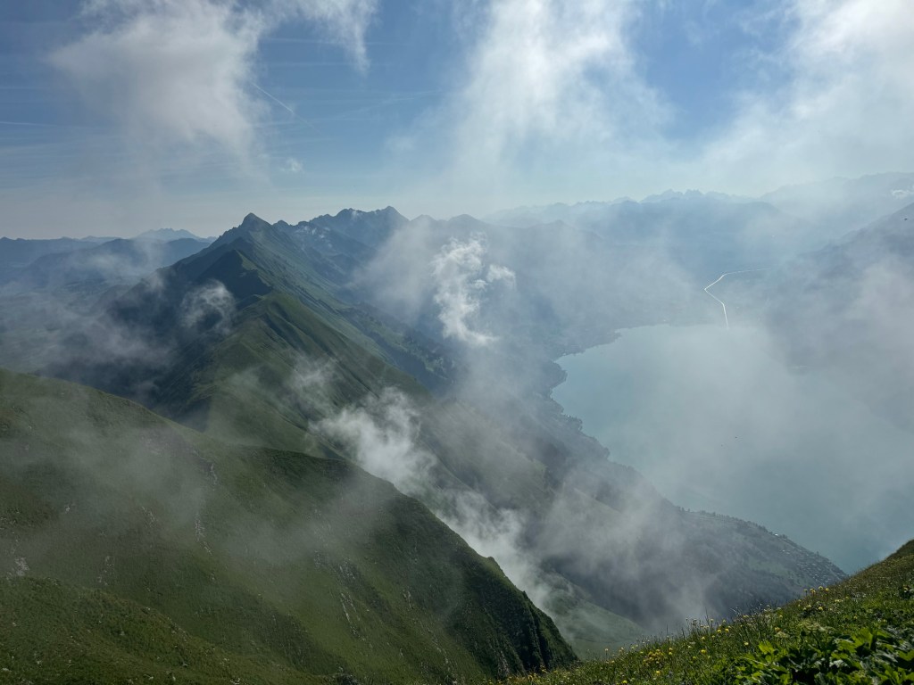
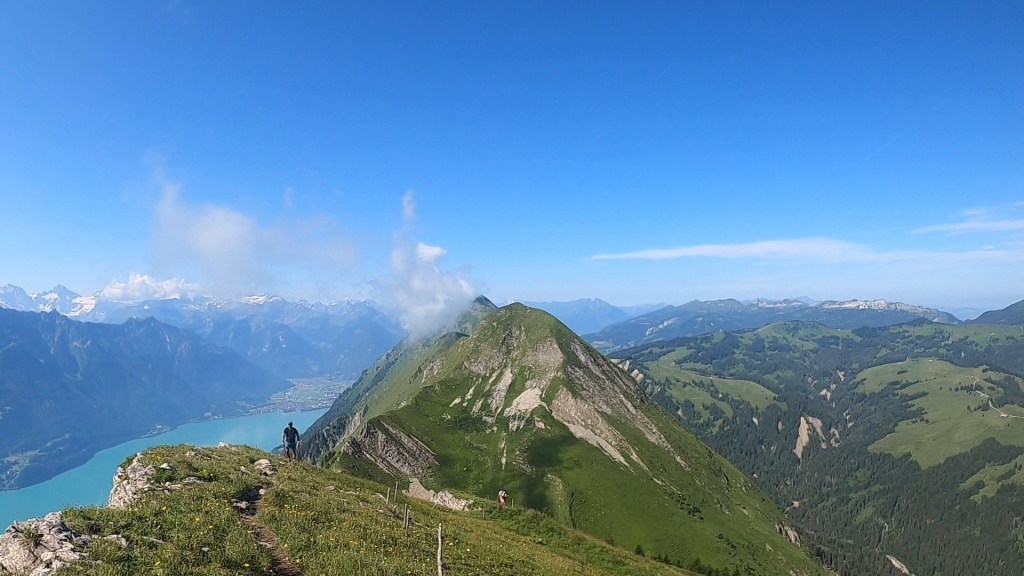
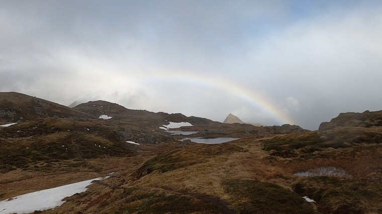
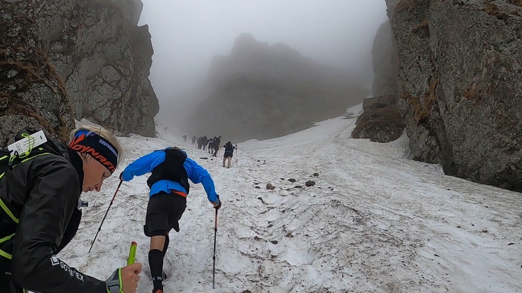
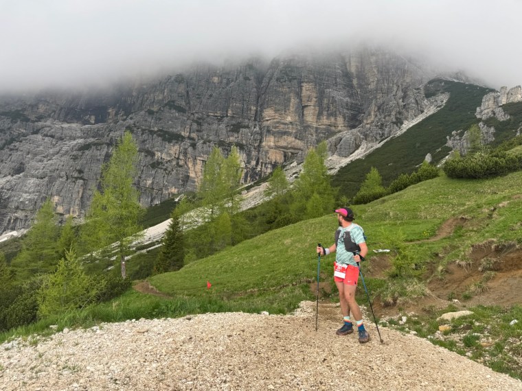
We were soon back out on the course heading to the highest point of the race. We were joined by an American called Paul and spent the next few kms together chatting away. It was a very long and steep climb ibn the forest. One of the biggest of the course. The foliage here was so different to what we’d experienced previously with massive leafy plants covering the ground as we hiked up slowly. The higher we got, the steeper it became. We were leapfrogging with many other groups of runners who we’d spent most of the race near. Eventually the path broke out of the forest and up onto the mountain top. Way off in the distance we could see runners climbing higher and higher. There were many false summits as climbed to a museum on the summit. Around us the clouds were forming, darker and darker and the wind picking up. It was cold and a downpour felt imminent. We knew from here, once we reached the museum we would back track and descend quickly on a road.

There would be no time to stop and enjoy the view, we wanted to get lower before we got caught if the weather was going to change. I did however need to stop as I found a tick on the side of my lower leg. As I sat and tried to get it out I started cramping and needed Matt’s assistance. It was a big one, even with a tick removal tool and Matt pulling hard and me holding my skin tight it was putting up a fight. Then with a loud popping sound it came out. It was the biggest tick I’ve ever seen. Thankfully it came out intact! Matt went on (as it was cold) whilst I re-packed my bag and then ran after him.

It was a long but fast descent. We dropped about 600m over 4 km. First on switch back pathed roads, then switch back gravel trails before into a steep drop in the muddy forest. We made it down though before any weather changes hit us. It was a good mental boost. The afternoon was drawing to a close and before long the sun would start to set. The lower we could get before darkness the better and we were into the last 16 or so kms of the race now with only one more big climb left to do. We had a new mission to get that through before dark and get to lower altitude (below 1,500m) before needing our head torches for the final push.

The climb came and went. It must have been like all the others we’d encountered (the race profile has it as one of the more prominent climbs of the course!) but my memory of it was over shadowed by the descent that came next…

spectacular landscapes

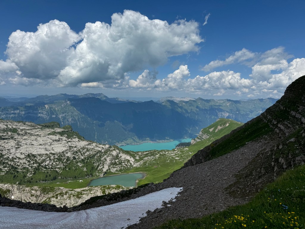
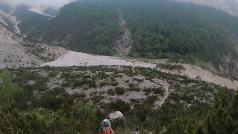
We were about 1,900m up and had to drop about 600m. Way way down below we could see a dried up glacier bed. In it was a tent. It wasn’t an aid station but we guessed some volunteers/mountain support. It was a dot way off below, and we couldn’t see any obvious way down. It looked like we would just be dropping off the side of the mountain somewhere. And so we did. It was a very technical descent. Often we were scrambling on all fours. We were tired and it felt quite dangerous (it absolutely wasn’t though!) in our exhausted state. It was a real bruiser on the fatigued legs and ankles. Day light was quickly disappearing as we navigated our way down, being thankful that we weren’t doing this in the darkness guided only by our head torches. After descending about 600m in 2km we reached the rocky glacier bed. We were so glad that was over! A quick stop and chat with the volunteers and we headed across the rocky terrain into the forest again.

Down to the tent we headed

We now had a very short but mighty steep climb in the darkness of the forest. Our watches were telling us the gradient of the climb was over 40%. It was pitch black and we struggled to see and navigate the course through the wall of soil that we faced into. It was a very slow and tiring climb which we were glad to get to the top of. There was a lady as we exited onto some farm land. She gave us conflicting information as to the distance to the next aid station. The volunteers at the Glacier bed, this lady and our own understanding of the course all came up with radically different distances as to the location of the next aid station. it was confusing but ultimately didn’t matter, we had to keep moving forward.

We had another steep descent through dark slippery forest trails. we were moving pretty freely downhill and Matt did a terrific job of navigating through the darkness. Somewhere in front of us we could here a lady’s voice talking away. As we neared Matt could tell she was on the phone speaking Dutch. There was a rocky section navigating over and along a river and we caught up with the lady who was chatting to her dad for company in the loneliness of the forest. Matt could here she was a little uncomfortable on her own and that she’d told her father there were some other people around her now which made her feel safer. Still, we held back a little bit and gave her space. We then found ourselves arriving at a cabin in the forest and the final aid station.

From here we still somehow had 12km to go to the finish. That last section felt so much longer than it was. At the aid station there was more confusion. We believed we still had two climbs on the course before the descent back to Forno di Zoldo. The route profile displayed at the aid station suggested that the aid station was located after these two climbs we thought we had. Another runner and the aid station volunteers were also saying it was all downhill now with no more climbing. It didn’t feel right, but we took their words for it. The lady asked if she could run with us through the forest sections for company and the three of us set off chatting away. I think she was pleased to hear Matt speak Dutch and find out he lived in the Netherlands. It turned out this was her first 100km event (incredible effort!) and her dad was at the finish line waiting for her.

We ran down further back into the dark, dense forests before we found ourselves climbing (yep, we knew it!) on a very long grassy climb. No more climbs my arse! The trails were twisting and turning and our orientation was completely messed up now. We had no idea where we were going and would catch up with other runners who were stopping and checking their navigation. The trail markings were few and far between now and difficult to spot in the darkness. The grassy trail did lead us back up onto the side of a mountain where the terrain quickly become very rocky as we traversed a path around the mountain. To our left a sheer drop in the darkness. We plodded along as quickly as we could move over the rocks, determined to get this over an done with. The enjoyment had left us many hours earlier! I kept moaning “why are there always rocky sections so close to the end of races to torture us?!”. The rocky path then led steeply downhill as we found ourselves heading back into a forest.

We were on it now though. We were hustling with a decent pace as the forest trails become more substantial and gravel tracks started to dominate. We knew that we must be close now and sooner or later we’d hit a main road that would lead us back into the town. Then, it did. In the distance a head torch. It was the Dutch Lady’s father waiting for her. We ran on and were power hiking along a road when he whistled and called after us. We were just about to miss the turn on the road. It was a huge, wide turn but not obvious in the night. The markings were chalk arrows drawn on the road and easily missed in our tired state. Thankfully he was there to ensure we didn’t continue in the opposite direction to the finish!

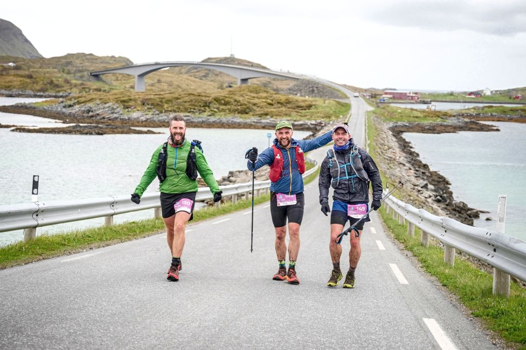
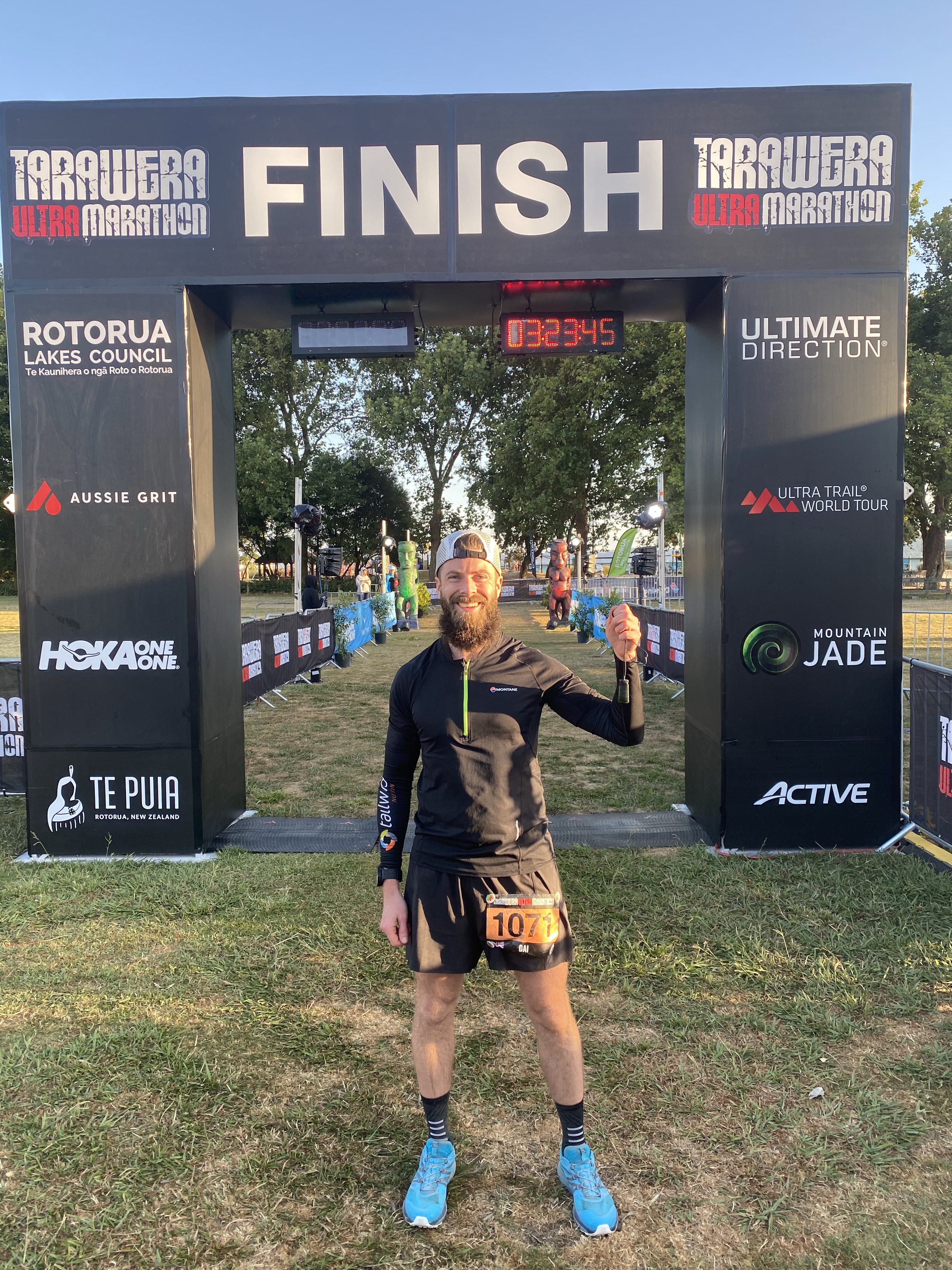
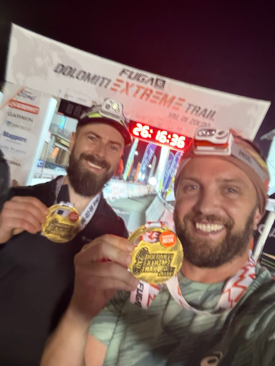
The road was long and climbed a little as we found ourselves crossing fields and farm land of smaller residential areas behind the main town. Then we could see and here the lights just below us. We rounded the bend and had a few metres to the finish line which we crossed just as the heavens opened and the rain started hammering it down! Damn we were glad that was over!

Moments before Matt broke his medal

After the race we collected our Medals (which Matt dropped and broke 5 minutes later), were given a finishers jacket (although similar we later found ours are both different from one another – we suspect different versions/models of the same jacket) and then tried to get a “finishers gift from the sponsors” only to be told there were none left as they’d only provided them for half the runners. As suspected, there was confusion about buses and if any were running (we weren’t the only ones trying to find one) so decided to go have a shower, get into warm dry clothes (thankfully my Drop bag was indeed waiting for me!) and then get some food whilst we figured out how to get back to the hotel. After the shower Matt had his broken medal replaced whilst I went off and found out that there was no more food available (great). The only success was when Matt proactively went and flagged down a bus driver who personally took us back to the hotel.

Looking back… I did enjoy the race and having another adventure in the Dolomites but the experience was dampened by the few organisational mishaps we encountered. Since day one the confusion over the buses left a sour taste in my mouth. The frustration over the drop bag going missing made my run harder than it needed to be and meant I ran with a dark cloud in my head for half the race. The continuation of a poor experience at the finish line just reemphasised how crappy the organisation was. Why they stop serving hot (any!) food when runners are still out on the course and finishing blows my mind. I was also cheesed off that the organisers/sponsors provided some additional ‘gifts’/merchandise for only some runners. The number of gifts seemed to vary from social media posts and information at the finish and it also seemed like volunteers were reserving gifts. Everyone enters and participates in the same way, so to then offer extras on a first come first served basis whilst the race is still happening immediately puts the slower runners at an unfair advantage. Either provide enough for everyone or make it first come first served the day after the finish. I sound bitter, but it is the principle and the frustration of the wider experience I had on the Dolomiti Extreme Trail.

Of the two events I’ve done in the Dolomites, the Lavaredo Ultra Trail is by far the better of the two. Not just because of the experience, but the Lavaredo trail does take you through far more scenic parts of the Dolomites.

Interlaken planetary, Interlaken planetary

A few years ago Paul did a solo adventure along the Hardergrat Trail in Switzerland. Ever since he’s been eager to go back with us to do it with him. We started scheming and found the time to form a plan and incorporate another visit to the Eiger Ultra Trail alongside the Hardergrat Trail. Paul, Matt and I did the E101 100km Eiger Ultra Trail back in 2022. Darryl and Natalia wanted to do the race too so it was perfect timing, to combine the Hardergrat with the E51 50km race the following day.

The plan seemed simple enough, fly to Switzerland on the Thursday, Do the Hardergrat Trail on the Friday, do the race on the Saturday and fly home on the Sunday. Efficient, although not the recommended approach for a race and a bunch of early mornings were for sure going to be tiring! We based ourselves out of Interlaken to take advantage of being closer to the Hardergrat Trail and more options for accommodation. We also had one shot at the Hardergrat Trail so were very dependent on the weather/ground conditions, which thankfully, were perfect…

Hardergrat Trail

The Hardergrat is a popular and well known hiking trail that runs along side the Brienzersee lake between Interlaken and Brienz. Although I say hiking trail, I don’t believe it is an official waymarked and maintained Swiss trail. Depending where you read, it is often described as one of the most dangerous hiking trails in the world. Whilst I don’t believe that myself and think there might be some dramatisation (I’ve felt less safe on some other trails I’ve done!), the risk is very real and it is well known that people have fallen, in some cases fatally, from the trail (there are many memorials and crosses along the trail!). It also isn’t for the faint hearted though and can be quite terrifying in parts. So if you are considering it, consider it carefully and plan appropriately!

The Hardergrat Trail (Seen from the other side of the lake)

All that said, we didn’t go into this lightly and had planned it very meticulously. Firstly we had Paul leading the way and he had completed the trail before. So we collectively knew the route and dangerous points and what to expect from first hand experience. Secondly we were only going to start if it was safe to do so. If it was wet, or indeed had been wet in the days leading up to our adventure, or windy, or any risk of the forecast changing unexpectedly for the worst, we wouldn’t be starting. We also planned to begin at 5am. The trial is over 25km long and has close to 3000m of elevation gain in total and finishes high up in the mountains where you either get a train back down, or descend over 1000m by foot. We didn’t want to feel any time pressure so we planned to start the hike from Interlaken up to Harder Kulm as early as possible (note, there is a vernacular that covers the ~1,000m climb to Harder Kulm, but this doesn’t start running till about 9am). We also planned to stop towards the end of the ridge and descend to Planalp and get the train to Brienz from there rather than continue all the way to Brienzer Rothorn. These trains finish around 4-5pm so you need to be ready to reach the end destination in time or face that huge descent on foot back to the lake (also worth noting it was about 40CHF for a single ticket down from Planalp!). Besides all that, the four of us consider ourselves to be well experienced on mountain trails and conditions and look out for one another. So we felt we were suitably prepared…

Our one concern was water. Given it is only really safe to attempt this trail in summer, and it is completely exposed along the top so was was going to be very warm, we wanted to carry as much water as possible, a minimum of 3 litres each. With the Harder Kulm being closed so early in the morning, there is no where along the trail to get water for pretty much the duration of the trail. Around Augstmatthorn I believe you could descend and then retrace back to the trail, but you’d be adding hundreds of metres of elevation and hours to your time, so you only really leave the trail here to start or finish a hike. We’d carry as much as we can and be sensible with the rationing.

We woke at 04:00 when our alarms disturbed our slumber. Had a quick breakfast and made our way outside around 04:30. It was a short run to the vernacular station where the trail to Harder Kulm starts. It is a forest trail winding up narrow switchbacks pretty much the whole way. I popped two Energy Bytes (caffeine sweets) here to help wake me up a bit and give me energy on the climb. It took us about 1 hr and a half to make the climb through the forests to Harder Kulm which was about 800m over 5km. From the restaurant and viewpoint here there is probably about another 300m or so along 2 km through the forest before the mountain ridge becomes visible. On the way, as we stopped and ate some sandwiches, a few others passed us including two brothers from America who we would see at various points as we leapfrogged each other along the trails.

It was beautiful seeing the sunrise through the forest and the morning mist giving way to these epic summits stretching way off into the distance. A long way below to your right, the lake looking like a gigantic hole in the ground. The mountain kept climbing until we reached Augstmatthorn around 14km in at some 2,100m up. Getting here we had our first taste of the ridge and some narrow sections. Many hikers stop at Augstmatthorn and make their way off the ridge. Another hiker we were talking to told us the route becomes much harder and more dangerous after this point (he had hiked it many times himself when he was younger he said). Somewhere along here there were also electric fences to one side of the trail to keep the cattle on the mountain side to the left. I know they are electric as at one point, whilst sitting down and resting, I brushed my arm against it and felt a tingle in my opposite ankle. This amused the others!

We carried on knowing we were a little under half way along the route we’d planned. What lay ahead now was a series of 7 or 8 mountain climbs. Each short (in comparison to what we climbed to Harder Kulm!) but very very steep. Some sections were rocky and had ropes and chains. Some sections had very clearly defined paths, but were right on the ridge and were very narrow underfoot. Some of the climbs were like walls and we scrambled our way up. It was very slow progress and we stopped atop of each summit to sit and enjoy the views and eat food. The views around us were pretty static. The view down and across the lake remained unchanged throughout the hike. The view to the left did change as the valley climbed through a mountain pass alongside the ridge. The view in front however was spectacular. With each summit we climbed, the descent became visible and the ridgeline curved off with a different perspective into the distance. Up and down we went…

It was a long slog as each climb was exhausting and we rationed our water more and more. Unlike when running in a race with aid stations, I was taking small sips to ensure I saved the water and had plenty for later on. Each big climb though would quickly empty a bottle. I played a strange game with myself where I was committing to not finishing a bottle before some point I picked in the distance. This felt counterintuitive but, the longer we progressed, the less water we had and the more it become problematic. One by one we were calling out just how many bottles we had remaining and the numbers were dropping quickly!

It’s hard to say for certain which memories and pictures correspond to which peak on the ridge. I do recall though that we passed plenty of hikers along the way, many doing it in reverse having taken the train up from Brienze and hiking back towards Augstmatthorn. One couple were lovely to chat with and I had a great conversation with the lady about the vibrant wild flowers all along the ridge. She told me to “take as many as I could and keep them in my heart”. I thought this was a beautiful sentiment. I also recall one particularly difficult descent which required scrambling down on all fours. For much of the ridge I kept my poles tied away in my pack and relied more heavily on my hands and having more points of contact with the ground.

Towards the end, the ridgeline was far narrower which caused the legs to feel more wobbly despite the clear and flat footpath we were following. Way off in the distance though we could see the Hotel Rother Kulm / Brienzer Rothorn Station which is the true end of the route. We weren’t going the whole way here but instead would escape down the side of the mountain and get on the train at another station at Planalp. For us, continuing to Brienzer Rothorn wouldn’t add much to our experience other than making it more dangerous – it would be quite a few more kms and probably two more hours or so, which we weren’t able to accommodate with water to sustain us. It wasn’t the timings that concerned us, but carrying enough water!

As we neared the trail junction where we could begin descending off the mountain we were all pretty much out of water. By now we’d ‘adopted’ the Americans who had made great progress but ultimately weren’t prepared for their adventure (think lack of training and deciding to do the hike whilst on a family holiday) so together we all descended. Even the downhill was tough going as our legs were now tired and our throats dry. We had about 600m of elevation to drop and about 4kms to go. In the distance we spied a water trough, however when we got closer it was a static one without a tap filling it up. We carried on. Paul had disappeared into the distance and Matt was somewhere between us and Paul. Thankfully after about 3km and 500m of descent we caught up with Matt at another trough that did have a fresh water supply. We stopped and drank about a litre each and refilled our bottles. A few hundred metres further on we all felt the groans of our stomach as the sudden intake of water and bouncing movements unsettled us!

Eventually we made it down to the Planalps station where Paul was nowhere to be seen. He’d mentioned there was a restaurant at the station which we couldn’t see. We soon found it further down the road with Paul sitting happily in the garden waiting for us and a cold panache! We stocked up on drinks of all kinds whilst we waited 45 mins for the next train (which we just squeezed onto) down to Brienz. Here we headed straight to the lake for a lovely cold dip to relax before making our way back to Interlaken. What an adventure! Now time for the Eiger Ultra Trail…

Eiger Ultra Trail E51

After a restless sleep and another an early wake up call we made our way to the station at Interlaken Oost to get the first train to Grindelwald along with a load of other runners. The train was quick and easy and we arrived 20 mins before the race started. We made the dash to the registration centre in the sports centre (we’d taken advantage of the opportunity to request registration on the morning of the race to save another trip to Grindelwald on the Friday!). The ice rink in the basement of the sports centre was gone and it wasn’t cold this year as we waited in the short line, collected our race numbers and dropped our bags off before making the way back to the start line. There were only 5 minutes to go before the race started so we settled into the back of our wave 1 start and then gently ran the 2km or so to the trails. We had maybe 10 runners around / behind us for those first few kms. As we got to the trail there was a big bottle neck as we queued to cross the river. We waited a few minutes at a stand still before we made it through.

Startline

Shortly after we began the first climb to Gr Scheidegg, the memories from the E101 a few years ago started to come back to me as we wound our way slowly up the switch backs. Last time we did this in the darkness so it was refreshing this time that I could see the trails and experience them, and the views, around me. We steadily climbed and enjoyed the short break after about 6km where the trail levelled out and we ran the undulating trails before the remaining climb to the first aid station. As we arrived, it was just as I remembered – a narrow set up that doesn’t really accommodate space for the runners. Navigating through the checkpoint in single file we grabbed some snacks and water and waited out the other side. We spent a while here eating and drinking and enjoying the early morning views of the Eiger before carrying on. I popped another Energy Byte to give me a kick and wake me up a bit.

Early views from the first aid station

From here to the next aid station, at First, was great. It is a short section of about 6km that has some runnable trails and gentle descents and climbs. All along it are panoramic views of the mountains surrounding the Eiger. The Eiger itself was standing magnificently proud in the cloud cover across the valley. Towards the end of the section we began the long, but gentle, slow ascent to the viewpoint and aid station. As we reached the top, the route markings took us across the trail and towards the viewpoint and the walking platform. This was Natalia’s first time experiencing such a long and exposed platform so we slowly walked along it to the sanctuary of the aid station, after getting some pictures of course! At the aid station I had my own party as I sat and ate loads whilst singing to the 90s pop anthems blaring out. Even though we’d only done less than 15km I tucked into the soups and bouillon available (it’s a popular feed station on the E101 route!). Eventually though we had to carry on.

I remembered the next section as we left First and made our way towards Feld. The trails were similar to before and led us towards some amazing lakes of Bachalpsee, naturally as we ran around the lakes the views were incredible. It really is a beautiful place. I pointed out Faulhorn to Natalia, the highest point in the race way off in the distance, a tiny speck on the mountain. Along here we met some other British runners who were part of a group running from Wild Trail Manchester, the group I spent a lot of time running in London with. After the lakes we encountered a small amount of snow on the trail which made it slippery, so we climbed slowly and carefully. Some smart arse behind us tried to rush past us and slipped in the mud and slid back down the hill. Not sure what he was trying to gain. He didn’t try to go past again.

Lakes at Bachalpsee

I knew the next section was quite rocky and technical (It’s even marked as such with ‘danger’ signs from the organisation). That much I could remember. I told Natalia to go slowly as it was rocky and now wet and slippery too. As we progressed we found ourselves near a lady who was clearly uncomfortable on the technical terrain. Knowing it was a short section I told her not to worry and to go at her own pace safely and we’d all follow behind. We stuck with her. Naturally a queue formed as we slowly progressed along the single track. After a while some prick behind us made a comment “it’s called trail running not trail walking”. I couldn’t hold my tongue. My usual polite and refrained manner was overcome and I snapped back to tell him that clearly there are runners who are not comfortable and that their safety is important. I told them that if they wanted too they could find an alternative route past and if they were such good trail runners then they wouldn’t be way back here in the race with us ‘trail walkers’ after 20km. No one said anything. No one tried to get past us. Go figure. It wasn’t long after that the technical trails gave way and the ground became more firm. The lady kindly stepped aside for people to pass her. We went past and started running. A few moments later I looked back, no one was keeping up with us. Says it all. Sometime later, on the next section after the aid station, we past the guy who made the comment as he was sitting on the side of the mountain on the next climb, clearly knackered. I was tempted to make a sarcastic comment then…

Anyway… After a short stop at the next aid station, Feld, we started the climb to Faulhorn. Before the race I couldn’t remember this climb. As soon as I saw it though I remembered. Like years before it was a warm day so a very hot and exposed climb. It is steep and slow going, a snake of runners slowly dragging themselves up to the top. In the sun it felt like it went on for ever. All the way up you can see the restaurant at Faulhorn, sitting way up high and ever so slowly getting closer and more in view. We kept pushing without stopping and made our way over the saddle and onto the last short climb to the restaurant were the trail takes you around to the back/top of Faulhorn. We stopped for a picture by the archway then joined the queue of runners waiting to get in and fill our water. Like many of the aid stations it is a tight fit (although this one on top of the mountain is justifiable with its limited space). I had a few cups of Coke that had been expertly whisked to a flat state by the willing volunteer. It was so refreshing in the heat.

We began descending and all the memories I was so sure of started appearing to have holes, giant black holes. As we left Faulhorn I was chatting to another British lady and I told her it was all nice runnable trails from here. It isn’t. I’d completely forgotten about the next section. First there is a short, sharp descent down from the summit. Then you make your way over rocky ground before the real descent began. This one is long and very rocky. There were a few short snow field crossings thrown in the mix too. As you make your way down you are descending on lots of large steep steps in the rocks, then further down we went, past the restaurant, on trails covered by snow burying the rocks beneath. I slid down on my bum as my shoes had no grip (I was very aware that they are now excessively worn but I thought would be ‘fine for the lovely runnable trails’ I falsely remembered!). Like the climb before it, the descent felt like it went on forever. As the trails started to re-emerge my head started piecing together the memories better as we made our way up a little incline to the water stop that is ‘Egg’.

It was actually this next section from Egg to Schwand that I recalled the best. My memories just made me believe the whole section from Faulhorn was like this. There are some lovely trails for the most part as you ran along the exposed mountain tops. Lots of tourists and walkers out enjoying the hike from Schwand to Faulhorn in he opposite direction. The mountains are exposed and you have these Epic views over the valley to the Eiger on the other side. Way off in the distance you can see another mountain restaurant perched on the side of the mountain. Below it, somewhere, the next aid station. It was a long way to go by sight, but not that long now you can move more quickly with the even terrain underfoot. We made a quick stop in some shade to apply more sun cream as it was getting pretty hot now.

Before getting to the end of the path, there was the ladder/step climb I’d completely forgotten about too. I piggy-backed on to a group of runners half way up and thanked the hikers waiting patiently to come down. After this it was a gentle hike up before we eventually reached the turning point where the downhill started. Pretty much from here it was all down hill to the final aid station. First we descended on lots of switchback trails to the aid station ‘Schwand’ though. This I remembered quite well as two years earlier Paul and I had stopped at a trough and desperately filed our bottles and relaxed, only to then see the aid station a few hundred meters further along. I recognised the trough (now covered up!) and pointed out the aid station to Natalia. We were ready for a break from the sun.

On the way to Schwand

After a little break in the shade and a ‘little douche’ from a volunteer with a hose pipe we departed. The trails led downhill into the forest. It was more technical than I remembered with roots causing the descent to be painful on my now very tired quads and ankles. The ground below was very spongy between the roots. This year I was prepared knowing that there was a sizeable climb during the descent. This caught us out back in 2022. It started in the forest then took us up as we crossed over a waterfall and then climbed further through a hamlet. I didn’t recognise the hamlet and it turns out that we went a slightly different route this time and climbed further. See, not all my memories are wrong! Eventually it was back into the forest as we began descending again and continued down towards the valley. We spent most of the descent in a train of people slowly making their way down gingerly. At some point the single tracks opened and we squeezed passed the group and were able to run at our pace. As the trail became switchback roads Natalia opened up and sped ahead. I couldn’t keep up. We could then smell (literally) the final aid station. We ran passed so many people in the short field as we ran down and into Berglauen. We took a few mins to refuel, deciding against the potatoes on offer, then set off. The final 7km to go back to Grindelwald.

As final 7kms of races go this is ace. It’s pretty much flat the whole way following the river back to Grindelwald. Over the 7km there is 225m of ascent and 100m of descent. Mostly this is grouped into three ‘climbs’ towards the end as you near the town. We ran/walked the whole way passing many runners as we jogged along the river. We then passed through a small village with incredible wood carvings (I now wish I stopped to take a picture!) and welcoming signs before crossing the river and running through the train station and over the train tracks for the Eiger glacier train (which we had to wait for and got a huge thumbs up from the driver). From here it was almost the final stretch as we stated to climb into the town and along the footpath to the point where the E101 joins from the opposite direction and we make our way up the final climb into the town. Its a short steep climb on paved road which everyone climbed so slowly. Once done, it was over! We we ran the few hundred metres down the town to claps and cheers from both sides of the road, round the final turn into the finish line area and down the familiar steep ramp to the finish line.

with our piece of the Eiger

Just like that it was over. We quickly escaped the busy finish area and went to collect our bags, change into fresh clothes, before meeting up with the others and making our way to the train back to Interlaken. It felt like a very long day by the time we had food and made our way back to the accommodation!

What a weekend! The Hardergrat was an incredible experience and it was special to see the mountains around Grindelwald again and share the race with Natalia. I don’t remember the race being as difficult as it was (and I won’t blame the run the day before!), it was certainly more technical than I remembered. We all agreed we wouldn’t want to do the 100k after experiencing the 50 nor could we believe that we’d done it previously!

You’re Late!

The Arctic Triple 100 mile ultra trail in Lofoten, Norway. An event I eagerly looked forward to but one for which my preparation was screwed before I even signed up. Back in 2022 I’d already signed up to Transylvania 100 and Mozart 100 for 2023. When Matt floated the idea for this race in Norway, and him and Paul signed up, I was torn. It ticked every box on our criteria for an adventure. Trouble was, it was a week after Transylvania (we’d actually start 4.5 days after the finish time of Transylvania!) and two weeks before Mozart. This was not an ideal time to squeeze a 100 mile event into my year. But I did, of course I did! I signed up. My plan was simply to survive and enjoy Transylvania without wrecking myself before Lofoten. That didn’t quite go to plan and the race in Romania was far harder and more damaging to my body than I’d hoped for. Come Monday, I could barely walk. Besides bruising to my right quad, my feet were in pieces. They were so sore and covered in blisters. It was 3 days of soaking them in salt water, applying creams and ointments and hoping for miracles.

By Thursday, miracles had happened. Somehow my feet had healed pretty well, well enough that I wasn’t in any discomfort, maybe still missing a few important layers of skin, but after a self inflicted stressful few days I was confident again. All that was left was the day-long journey to Svolvaer where the race headquarters and finish line was based. That night, I wrapped my feet as best I could in hypercolloid dressings and KT tape. I hoped this would buy me a bit more time during the race before further damage was suffered. I also opted to wear waterproof socks to start the race (which turned out to be the best decision I’d made that week!).

The next day the journey to the start line began, this was like an ultra in itself – it involved a 2 hour bus from Svolvaer to Reine and then a 30 minute boat ride to Kirkefjord. The bus journey to Reine was scenic and gave a good first insight into the stunning scenery and terrain of the peninsula. We drove around the islands and mountains making up the landscape and crossed bridges and went through tunnels that connected all the islands. The mountains were quite a sight and dominate the skyline.

Suited and booted for the boat ride

At Reine we left the bus to get a boat across the fjord to Kirkefjord where the race would start. Due to some logistical issues, the planned ferry boat wasn’t available, therefore smaller boats would complete the transfer. This worked out amazingly for us as we were stopped before boarding the boat that was waiting when our bus arrived as it was full. Instead we were directed to a smaller speed boat/dingy. This meant donning a life/body suit. I made sure we were first in line to get suited and booted. This boat looked so much fun! Straddling the seats we held on as the boat sped off. Wow. What a way to start a race and what an experience bouncing along the water, the wind and rain battering our faces. The attempts to disembark were then hilarious as we tried to climb up the jetty and needed pulling up from the marshals directing us in.

We had about 45 mins before the start and spent it sitting in a wood cabin on the ‘pier’ to take shelter from the rain and exploring a vacant building. At midday, as we made our way to the start line, we found ourselves at the front of the runners. This made us giggle as we did not belong there, but we embraced it as we set off, momentarily leading the other 70 or so runners into the adventure that awaited…

The race starts with two steep climbs. The first about 100m and the second a bit more punchy at around 350m. Straight away I was huffing and puffing. The terrain was mountainous, rocky and wet with water streaming down the slopes. The incline was sharp and the gradient reached a good 30 degrees in places. Runners inevitably started passing us as we climbed. As we reached the top the of the first climb the fun began. Groups of runners started passing us at speed as we tried to navigate the slippery, rocky terrain. In some parts small remnants of snow made the rocks extra slippery. I wasn’t ready for more snow after last weeks fun in Romania. I was making my way tentatively.

Leading the way. Bunch of clowns

I cautiously crossed the trails connecting down to the second, steeper climb. I fell a few times along the way, slipping off the large boulders we had to traverse. As we began climbing again the story repeated itself. After reaching the top another tranche of runners went passed. We were now near the back of the field already. We’d barely been running an hour and already couldn’t keep pace with everyone!

The race description and briefing did indicate that the first 20km or so made up some of the harder sections of the race, so we weren’t disheartened just yet (even if we were only about 6km in!). Besides, from here we began the route towards the beach at Kvalvika as we descended again. We had a short road section and the first checkpoint with refreshments before we were heading off track again towards the beach with a short climb and descent along the way. Here we started to be caught by some of the relay runners who started after us. You can also cover the 100 miles in a team of up to ten people. In 2024 they are also offering the 100 mile event as a multi day adventure. The views, despite the wind and rain were incredibly pleasing on the eye. We knew about this beach after watching the short film ‘Nordfor Sola’. It’s about two young men who embark on an adventure and spend 9 months living on the remote beach, building a ‘cabin’ out of materials that wash up on the shore and that they salvage.

The beach is split into two sandy bays. As we reached the first, the trails took us right to the coast. By now Matt had fallen numerous times, the last one spraining his wrist. He was in pain, but masked the pain with his excitement of reaching the beach. The descent to the beach itself was very challenging. We clambered over large boulders and loose rocks, lowered ourselves down cracks and used ropes and chains to reach the beach. It took a little navigating for us to find our way down and the rope descent was tough going, even if it wasn’t very high! We immediately then had to climb and clamber back up and over the wet rocks to work our way around the coast.

The ropes and boulders connecting the beaches made for slow going

Eventually we reached the second beach. The one made famous from the film. In the distance we thought we could see the the makeshift chimney from the cabin. A surfer was preparing himself for a dip in the vast Atlantic ocean as we began the long, wet climb away from the beach. Again, barely a 200m climb, but the incline was steep and the soggy wet ground made for slow going. This would be the theme for the climbs in the course. None were particularly long or high. But they were steep and always sapped the energy and reduced us to a snails pace. At the top a Photographer waited patiently and snapped the runners as we made our way onto the boardwalk planks installed over the boggy ground. They kept our wet feet from getting even wetter. The solid ground was greatly appreciated. The descend took us back along some gravel tracks and boggy downhills towards the next checkpoint, 20km in at Fredvang. We stopped for a short rest here having some warm soup and plenty of the ‘Triple Buns’ (kind of like a fruit loaf bun) which were excellent. We studied the route for the next section and made some mental notes of the runners around us. We were conscious that there was a new cut off (noted during the race briefing) at the 56km mark at Napp. We had 14 hours to get there but had already taken 5 hours to cover the 20km to this point. It didn’t make for good thinking, but we held on to the belief that the trails would soon get ‘easier’ and we’d reclaim a little time.

Leaving the Check point we carried on for a few kms along the road, crossing two bridges connecting the islands. There would be plenty of bridges along the course and these first two gave the initial impression, with steep inclines and descents either side (the steep shape allows for the passage of boats underneath!).

The roads then gave way to gravel tracks and, as we neared the southern edge of the island, we were back into the boggy marshland and forests near the coast. The wind and rain was continually battering us and we found this section particularly cold with the head-on wind. The coastal section was tough going and we were all over the place trying to follow other runners and navigate our own way through the bogs, sometimes slipping knee deep in the stinky mud. I was so thankful for the waterproof socks at this stage!

Professional photographer’s image of some of the wetter terrain and bogs

We were very wet now with the heavy rain pelting us from all angles and the ground soaking us from below with every step along the spongy ground. It took us about an hour and a half to cover the 7 or so kms here and emerge back onto some beautiful coastal roads making our way to the next checkpoint at the picturesque fishing village of Nusfjord. We rounded the buildings and into the shelter of the checkpoint.

The checkpoint was outside but we made good use of the shelter with heaters and blankets. We could feel the icy wind blowing from the sea so tried not to spend too long tending to our needs. Somewhere in these opening kms I’d noticed my eyesight was a little bit hazy. I’d covered up my left eye and realised everything through my right eye was blurry. It occupied my mind for a while as I’d had something similar back in January when running the Tea Round in the lake district. By the end of the run I’d lost eyesight in my right eye. It came back when I woke the next day and I put it down to a bit of mild snow blindness after running for 13hrs in the snow. I’d made a note to myself to keep being aware of it as I’d a lot longer to run this time and it clearly wasn’t related to snow! We stocked up and refilled on more triple buns, emptied our shoes of excess sediment from the bogs and warmed our hands under the hot water tap. 8 hours and 40km covered, we’d reclaimed a little time and were confident of the impending cut off at Napp. Which was good, because the next section to Napp was said to be particularly challenging and we were warned by he Race Director during the race briefing not to be deceived by the relatively flat route profile for this section. We continued to hold on to that belief that, if we got through this next section, things would become little bit easier. We just set our sights on Napp 19km away and headed off towards our target…

One of the professional photographer’s captured this incredible view of Nusfjord fishing village

By now it was night time. Night time was a little different here as we were inside the Arctic Circle. During these months of the year, the area receives 24 hour daylight. Not having the changing atmosphere as darkness set in was certainly an unusual experience for us. Hopefully it would mean our tiredness would also be kept at bay and the daylight would help keep us awake – we were tired with the long day of travel, early start and effort of the first 40km. Anything that would keep us moving forward would be welcomed. The road out of Nusfjord continued for a few km, we passed some drying fish (we’d learnt about the fishing industry and exports of dried fish heads to countries like Nigeria from some local runners on the bus ride out) before we headed into the forests and started climbing.

Fishing villages were covered in these fish drying stands

It started with a slow and steady climb on loose scree. We jokingly (seriously) hoped this was the ‘technical’ element. Of course it wouldn’t be. We climbed further and the visibility got less and less as we entered the mist. We barely climbed 150m before we began descending on more of the same terrain with a well defined path and limited visibility. Inevitability more marsh and bogs lay in wait as we left the path and head off track with several more smaller climbs and descents to cover as we made our way back towards the coast.

Climbing into the mist just outside of Nusfjord

Once we reached the coastline it was a particularly treacherous coastal section. I just recall boulder after boulder putting further stress on our tiring legs. More ‘light’ scrambling and scaling waterfalls (frustratingly my GoPro battery was playing up here so I’ve no visual records of this whole section, the professional photographer photos however capture a little of this brutal terrain!). It was beautiful and surreal but arduous at the same time. I don’t think I’d imagined that I’d spend so much time on his race on all fours in the water trying to haul my ass upwards. It was very slow going. The weather didn’t relent and we were cold and frustrated. I had three pairs of gloves on and had started ripping the waterproof over-gloves from all the climbing on jagged rocks. After what felt like a lifetime of navigating the coast we found ourselves upon the ‘small’ ladder mentioned in the briefing (mentioned as a safety notice as the bottom was a little broken), but it wasn’t quite what I’d envisaged. It looked huge to me. Not long, just oversized. Like it was made for some Nordic God. Down we went, my hands barely able to wrap around the rungs of the ladder and hopping to safe ground near the bottom. From here the theme continued as we descended further, still battered by the wind and rain. We had now resorted to sitting on our bums to lowered ourselves through cracks and gullies. My waterproof over mittens were now ripped and a hole torn open. I questioned why I buy myself nice kit and then do these events and break everything!

It probably wasn’t as bad as I remember, but it did take us a long time. Looking back it took us about 2 and a half hours to cover 10km along this coast. We had a few small navigation errors as we tried to keep the pink flag markers in sight. I can’t recall how, but it eventually came to an end. Somehow we came out into the village of Napp, ran along the road and found the school where the next checkpoint was. We were relieved, we’d been going for about 12 and a half hours now and were very much in need of a rest. Thankfully Napp was where our first drop bag could be retrieved and we had time. We took about an hour here sorting ourselves out. As we started changing our clothes a thoughtful volunteer started mopping up the water that we were leaking. It was everywhere. She also appeared with a bucket when Matt had a coughing fit. He had to reassure her he was ok. We’d planned this stop ahead and all had plenty of warm, and spare kit to change into. With warm kit on and more soup and triple buns consumed, I set about ‘preparing’ my feet for the next section. I was surprised that they had held up so well. Compared to the others, my feet looked great and in far better shape. The waterproof socks had worked wonders. I cleaned them up and dried them off, applied fresh compeed and taped over my soles, heels and little toes. A fresh pair of socks (more waterproof ones!) and dry shoes finished off the pitstop. I wasn’t making the same mistakes I’d made last week in Romania and was super confident that I was managing my body better.

After a good dry out and reorganisation we set off. We even had toasty fingers after warming our gloves a little on a radiator (spare dry gloves would be the one addition I would have made to my drop bags in hindsight!)! From Napp it was a short road section before a 2km stretch through an underground tunnel. By now it was about 2am (so confusing with the day light!) so there was minimal traffic in the tunnel. A lorry did pass us as we were ascending out of it and and the roar and echo was deafening. Being on flat ground, I ran this section with my Buff covering my right eye to try and ‘rest it’ a little bit and hopefully give the eyesight a chance to recover. I looked like a right Pratt.

Emerging from the tunnel we looped back on ourselves for a circumnavigation of a big ol’rock – the mountain Offersøykammen. It stood there prominently for the whole section as we ran around it. It started with gentle trails which soon became became wetter and rockier. Before we knew it we were back on boulders, scrambling along the coastline and deviating onto wetter sections where safer (we heard the following day that a runner fell and broke their ribs along this rocky section, we don’t know if that was substantiated or not though). There were a group of runners here. We talked a little bit acknowledging the difficulty of the course and conditions. As the race description says ‘this section is hardly any trail and more technical following the rocky coastline’. It was nothing but accurate! The trail looped us out onto the road which we’d now follow on a diverted course – due to local land restrictions this year, we’d avoid another coastal section to the north and instead loop south to Leknes and Brustranda before re-joining the original route further along the E10 road. We ran through Offersøy and continued on the road to Leknes.

The group of us jogged on in our own paces. Interchanging leaders and varying progress along the road. We felt we put a pretty solid shift in and ran consistently here with short walking breaks as the road inclined. We were aware that these long road sections, as tiring as they were, would be our only chance to gain some ground in a race against the clock. We made good progress, although we could all feel that fatigue was beginning to set in. We’d been up most of the night and the benefits of constant daylight was starting to wane as it was now passed 04:30 in the morning. After hitting the cross roads at Leknes it was a straight line to the checkpoint at the hotel. We entered and the first thing that struck us was that it was so warm. It was great. The smell of warm food filled the room. We discussed having a power nap so found a table and put our heads straight to rest with a timer set for 10 minutes. We needed a recharge. As we woke we went in for the food. There was a sausage (single!) and some wraps that we shared. We tucked in and, at 30 mins, probably stayed a little longer than we should have but we were ready to go again and very much needed to close our eyes for a short while. Most of the same runners who’d arrived before or after us were still here too, so we weren’t overly concerned as we braved the cold once more.

I loved this view on a coastal road. It was a earlier in the race and a long time before we reached Leknes

The next section was about 17km and mostly road as we followed the diverted course to Brustranda. Almost immediately my feet started to hurt. I was a little frustrated as they’d felt so good up until now and we were only half way through the race. I’m not sure if it was the long road sections or something else (thicker socks in the shoes?) but I could feel the start of some feet troubles. There wasn’t anything I felt I needed to do immediately, but I couldn’t ignore it for too long! The road running continued with a long up hill hike and a gravity fuelled downhill trot. The rain was intermittent now and we were commenting about how frustrated we were of taking our hoods off and putting them back on again. The temptation to leave it off was high, but it was still very cold, even here inland further from the coast. From the down hill the road continued what felt endlessly. We weaved around the landscapes with more breath-taking views as we made our way back to the coast at Justad. Here we ran again with the ocean on one side and steep dominating mountains on the other. We’d pass through small settlements as we continue along the coastline. A photographer passed in his van, pulled over and snapped us before continuing on again. We sensed (prayed) that the section would soon end but the inlet where the ocean met land seemed so far away in the distance. Our run had become a jog and our jog had become a plod. My feet were on fire and I knew I couldn’t wait beyond the next checkpoint to address them. It took us about an hour and 40 minutes to cover the 10km before we came upon the campsite at Brustranda Fjordcamping and entered the warmth and sanctuary of indoors. We were loving these checkpoints. They were all well stocked, spacious and warm!

Roads out of Leknes

As Matt and Paul went about refuelling I went to work on the feet. Blisters had formed on the pads of my feet and on the heels and more hotspots were becoming apparent along the soles. I dried the feet, removed the tape, applied another four compeeds (supplementing those still in place from the last touch up!) and secured with fresh, dry tape and new socks again. It still hurt but I was hopeful it would minimise the damage that was now inevitable. I packed up and we left. No refuelling here for me. I’d have to make do with my own, ample supplies on the go. A slightly quicker pitstop at around 20 minutes this time. We’d covered about 95km by now in just over 20 hours. Despite the extra stops and rests this felt like a good time, even if all the other runners we’d been near had now left us behind and picked up the pace.

As we left we took note of the specifics of the next section. At 24km it was the longest of the route. It also had one of the biggest climbs (although still a mere baby at about 450m) of the route. We started the slow climb. Stopping shortly so Matt could quickly assess and fix his own feet after feeling some discomfort shortly after leaving Brustranda. With a long way to go it wasn’t wise to wait until we next stopped. This gave me the chance to take on some food. As we started off again the climb started to increase in steepness. We meandered through streams and muddy tracks before huffing and puffing our way up into the clouds. The climb was broken up slightly as we made our way towards Vårliheia and Tjønndalsheia. Up top, there was snow on the ground in places but otherwise vast hills of nothingness. The views were endless but the terrain barren and bare. It snowed a little and the wind really picked up so we tried to keep moving and get off the summit as quickly as we could. Mostly off track, we made our way down along soft (of course wet!) lumpy ground similar to somewhere like the Brecon Beacons (Matt and Paul often related the terrain to the Highlands, but I don’t have that experience for comparison).

Steep green climbs with some added snow

We lost track of the route a few times and I was slowing behind Matt and Paul on the long twisting downhills. I slipped at one point in comedy fashion. The wet flat grass beneath my feet caused me to slide and turn before I fell backwards on my bum and slid down on my back, coming to a gentle stop in the wet grass. I laughed it off but was a little annoyed at how wet my gloves now were (these were my dry gloves that had been kept dry when wearing the waterproof over-gloves in the rainy sections) and how cold my hands would now be. Still, nothing to do other than pick myself up and try and catch up with the others.

amazing views up high

Once regrouped we emerged off the mountain and back on to a road. Here we’d follow the road all the way around the lake Innerpollen. Whilst thankful to once more be on a dry and stable road, it was a good 17km that lay ahead of us. The view of the lake from the mountain put it into daunting perspective – it was a long way to run after more than 100km and almost 25 hours of running!

I find that in most long distance, endurance runs there is a section where the memory becomes a bit of a blank. This navigation around Innerpollen was it for me in Lofoten. For Matt and Paul too I suspect. I can recall the road, the views, how we were feeling and the distorted passage of time. What I can’t recall is how it took us as long as it actually did! Looking back at the GPS data, it took us about 3 hours and 20 minutes to cover about 14km after we got down and away from the mountain. Almost twice as long as the 10km section leading in to Brustranda when we were hurting and plodding around the coast. At the time it felt long, but it didn’t feel like it was that long! We were very tired now. The weather had dried up and it was warmer than at any point in the last 24 hours. The problem now was that all three of us were bonking at the same time. This is quite unusual that we all become so synchronised in our tough and difficult periods. Normally at least one person is in a position to take control and lead, dragging the others on with a bit of intention. Not this time. I think in our bonks we slipped into a state of limited consciousness. By that I mean we were moving forward, just with limited momentum and purpose. We were stumbling side to side, each of us closing our eyes and experiencing little day dreams (I kept jaunting awake when I repeatedly mistook the white lines on the roads as planks of wood at head height that I was about to walk in to!). Matt was doing his best to try and keep us focused, trying to engage us both in conversation. He did a great job, asking simple and specific questions to generate discussions and get us talking. Sadly I don’t think Paul and I were that responsive though. I also recall the endless amount of toilet stops I needed along this road. I don’t think I’ve ever been so hydrated in my life!

As our stumbling continued we focused on the next check point at Torvdalshalsen where we’d get our final drop bag. We’d already agreed that we needed another power nap once we reached the check Point. There would be a few mountain passes and ridges to overcome later in the course and we weren’t in any fit sate at that point to attempt them. As we neared the checkpoint we started to be passed by the leaders of the 50 mile and 50 mile relay races. This gave us a little focus as we clapped and cheered them passed.

In the distance the pink flag at the aid station could be seen. We made our way there, smiled and laughed with the race director and volunteers as we entered, retrieved our bags and went to sleep with our heads on the table once more. I requested 15 minutes on the timer this time and Matt obliged. As we woke we found another lady on the hundred mile race had caught up with us. I was happy for her as I remember her from the aid station at 20km and she was worried about making the 14 hour cut off at Napp. It also shocked us a little into action. She was once more worried about the next cut off, so Matt started crunching the numbers. She was right to be worried. The calculations weren’t good news! We had about 27km to go to the next cut off (around 144km in) but only 6 hours to make the cut off. Given progress throughout the last 28 hours, this was going to be tough. The profile of the next section just made it a struggle before we’d even begun. The next 15km had a lot of the ‘lumpier’ sections of the route with 2 climbs of about 350m each. Sandwiched between them were smaller climbs and descents. Once we climbed the second mountain and descended to the coast we then had a 12km road section to the check point with the cut off. It was going to be tight. We set ourselves a target of 4 hours for the first 15km in the mountains and then 2 hours to navigate the coastal road. It was ambitious but it was all we had. I patched my feet once more, fresh socks and fresh shoes and we headed back out.

By now loads of 50 mile runners had passed us and we could see the route way off in the distance marked by dots of runners ahead of us. Refreshed and up against the clock we were moving with purpose again. The first climb was arguably forgiving in terms of terrain with a well defined single track leading the way. We passed some photographers we remembered from the boat ride the day before and they cheered us on. We were feeling it, the joy of the trails and the pressure of the chase. We were blocking out our pains now and power hiking up the hill and jogging where we could along the flatter parts and descents. In between the two big climbs the trail descents again gave way to the mud and we found our progress slowing. The flatter sections connecting the climbs were off track along more soft, marshy terrain with huge tufts of foliage to clamber over. I felt my right knee twist and twinge. The pain was instant, but I just added it to the list of things to ignore.

Focused and determined on the climb out of Torvdalshalsen 

As we rounded corners and mini-summits, we followed the lines of runners. Then our Jaw dropped as we saw the ascent into the clouds ahead of us. Silhouettes of runners disappearing into the sky. Like all the climbs out here, the elevation gain was incredibly deceptive. I don’t think that 350m elevation gain is a big climb. The steepness and terrain however tells a different story. We sucked it up and slowly followed the runners into the clouds. The time pressure pushed us on and we summited with about 3 hours to go before the cut off. We were trying to estimate the distance remaining in this section and settled on about 6km or so. We thought a 1 hour downhill 6km was still achievable. Lofoten had different plans for us though. The descent began with a traverse along a ridge. The snow was falling and the wind had picked up again (it was late evening again now). In the race briefing this was one of two sections the organisers were monitoring and would divert us if the bad weather predicted took hold. The weather wasn’t as bad as expected so they deemed it safe for us to continue. Safe, but that doesn’t mean easy!

The ridge was a little intimidating. I’ve been on worse, but probably not after 30 hours of running. I was thankful though that my eyesight had fully returned (it had at some point earlier in the day but I hadn’t acknowledged it!) and I began leading us on our descent. The benefit of the ridge was that we covered significant elevation drop very quickly once we were off the ridge. The downside was it slowed us significantly and we had a real battle on our hands now. I was clock watching constantly, watching the minutes disappear. We sensed we were nearing the coast and the next check point, but the path kept winding us away in all different directions. We were back in wet marsh land, meandering through mud and streams, slowly but surely heading to the coast.

Eventually we hit the road and saw the check point in the café. It was quarter passed 6 in the evening. We were behind our pressured schedule. We had to stop and grab water and refuel. It was chaos we were all over the place, spilling drinks and food and trying the patience of the ever so helpful volunteers. We turned it around in under 5 minutes and set off. We had a little less than 1 hour and 40 mins to cover 12 km on the coastal road.

We still believed, somewhat naively, that we could make it. In our favour was a burning desire not to give up, to keep on going, to not fail. We clang to the hope of ‘its a road section’. Against us were so many factors: 130 km and 30 hours of fatigue and pain in our bodies. Our performance – at the best of times it takes me 55 mins to an hour to complete a 10km road run, to expect near similar performance now was unrealistic. The road was also against as it had ever so slight undulations and climbs, changes in elevation between 5 and 10m were enough to derail our attempts at consistent running. We also knew we couldn’t sustain a running pace for an hour and a half. We’d have to break it up with some walking.

We were plodding along full of beans and belief, maybe less than a km after leaving the check point, when Paul was crunching the numbers and working out our pace. Whilst we felt satisfied with our sub 8 min/km pace, Paul put it into perspective that it still wasn’t good enough. At that pace it would still take us over an hour and a half to cover the remaining 11km. We ground to a halt and walked the long gradual incline we were on. So many thoughts going through our heads as we tried to work out different ways to approach and over come this section. We continued with the run walk strategy and ticked off km after km. Each one we ticked off made the picture ever more clear. We weren’t going to make it in time…

It wasn’t necessarily that we couldn’t make the cut off, we still believed we could. It was more what it meant to make the cut off ever so tightly. After the next check point we still had approximately 20km to cover with the larger climb of the route and a longer mountain ridge section to cover. Before we could attempt that we at least needed a few minutes to stop and refill our water. Getting in at the cut off wasn’t enough, we really needed to arrive at least 5 to 10 minutes under the cut off. We were in a unique juxtaposition now. The more we ran, the more we exhausted ourselves and the harder it came to continually push the pace. But the more likely we’d make the cut off, but also the more likely we’d then crash and burn.

The saga continued as we reached the crossing at Sundklakk. Way off in the distance we could see the Gimsøystraumen bridge which we’d cross before the checkpoint at Kleppstad, our target. I think it was here that reality started to set in and when we really started to accept our fate. We had little over 30minutes remaining. Some 50 mile runners and, to our surprise, two more ladies on the 100 mile race caught us. We really believed we were the back of the pack, well, we were now! The other runners seemed overly optimistic (good for them!) that they were going to make it. They kept telling us it was only a few kms to go. We thought differently, believing it was longer (and were right, it was still about 5 kms before we passed over the bridge and into the check point).

The final moment of acceptance as we approached the Gimsøystraumen bridge

These 5 kms were some of the longest I’ve ever run. Fighting the losing battle against time. Defying ourselves not to give up, but simultaneously accepting more and more with each step that we just wouldn’t make it. The inevitable happened and we gave in to the long walk to the checkpoint. No amount of pushing through the pain and running would change our destiny now. We walked more and ran less. Not long after our walk lost its purpose again and we talked and cheered each runner passing us that still held onto the dimming glow of hope. After a slow walk over the bridge, we arrived at Klepsatdd. It was like a ghost town. The Arctic Triple Trail flag being the only indication that this was the aid station. We tried the doors but couldn’t get in. It looked closed and locked off, chairs on top of tables and darkness inside. Eventually Matt found someone inside who directed us to the door. We still couldn’t get in. In our tired state we’d completely missed another side door that was the way in (in our defence it was clad the same as the building!). The lady greeted us with a very stern “You’re Late”. We asked if we could continue, she didn’t see the funny side and reiterated that we were late.

Part of us did want to continue, we’d come so far after all. But we accepted our fate was sealed. The final few kms of walking had meant we were now well passed the cut off and another one loomed in less than 4 hours after the next mountain ascent and pass. No way would we have made that, even if we had made this cut off in time!

Inside we saw most of the runners who’d passed us on the road. None of them had made it in time either. The volunteers were helpful and gave us warm food and drinks and information as to when a bus would be available to take us back to Svolvaer. There was one leaving soon which we might have been able to jump on but in our politeness we let someone else take the last spaces. We might not have been so polite if we’d realised we’d have to wait another hour for the next one!

Back in Svolvaer we had to walk to the finish line to return our trackers, collect our bags and ponder “what could have been” watching people finish the race. The consolation was a lovely fish burger available to runners which certainly warmed us up and filled our bellies a little. It was now nearing midnight and I was eager to wash the bogs off before getting some sleep and beginning the long journey home the next day…

Reflections

  • What an adventure! Lofoten is so wild and remote. The little villages we ran through were so isolated and peaceful. The back drop of towering mountains and the ocean is an incredible combination. It is such a beautiful place and one I’m glad to have explored a little.
  • Despite the result, we loved it. The race organisation and volunteers were fantastic (the race briefing was very informative!), the check points and support were brilliant and the location was just unreal!
  • The boat ride only made the whole experience even better!
  • The terrain out there is gnarly! I’ve done a lot of trail running around the world on some difficult terrain. This was something extra though. I described the mountains like someone had chopped the tops off them and just placed them close to the sea. At only 300m – 500m+ elevation it felt like you were over 2000m up. The mountains very quickly become steep, sharp rocks. The weather up high changes rapidly and varies significantly from that just a few hundred meters lower down. When not in the mountains, it is just wet. Consistently probably the longest I’ve spent in bogs. Far more so than runs in Snowdonia and the notoriously boggy Cheviots!
  • A phrase Paul used was “you’re not in Kansas any more Dorothy”. This was so true and to the point. A lot of the ‘big’ European races in the likes of France, Spain, Italy, UK, Austria, Switzerland etc., have exceptionally good trails. If you’re looking for well maintained single track trails, this part of Norway is not for you.
  • I thought the road sections would make it easier. I anticipated we’d have greater control over our pace and when we ran and when we walked. They didn’t, they just sapped our energy and enthusiasm. Our bodies had different plans for the roads. That said, the landscape was still incredibly beautiful, even when running along the roads.
  • My perception of time has been completely warped. I’d describe this as one of the harder races I’ve done. Although, making the vaguest attempts to compare races – we covered the 100km distance in about 6 hours less time than it took me to run Transylvania 100km the week before. Compared to the more forgiven Alpine and Pyrenees trails, we were on course for a far quicker 100 mile time than what we achieved at Val D’Aran or UTMB (broken ankle aside!). This felt longer and harder in parts than these races. The cut-offs are tighter that is for sure!
  • Let’s be straight, we failed. I hate all the self-motivating and congratulatory crap around ‘but I did not fail’ people use when referring to DNFs (Did Not Finish) classifications. We absolutely did fail. We set out to run 100 miles and knew the cut offs. We didn’t finish the course and we didn’t achieve what we set out to. Say what you want, this is a failure. It is black and white for me.
  • The failure doesn’t subtract from what we did achieve though. 90 miles and 32 hours – it was one hell of an adventure and exactly what we signed up for. Only 22 of the 47 starters went on and finished the 100mile event.
  • Looking back, how do I feel about not finishing? Surprisingly ok about it. Yes it hurt, yes it was frustrating, yes there was and is still disappointment. But I’m ok with it. There doesn’t feel like there is anything to ‘deal’ with. We had the adventure we set out for, we’ve memories that will last a life time. I think I’d feel differently if we were timed out earlier – image it happened at Napp after 56km, then it be pissed and annoyed and would definitely feel a need to try again. As it stands I am completely at peace with it. I don’t feel a desire to got do those last 10 miles.
  • Perhaps I’m ok with the DNF because we didn’t give up. Right up to those last few kms we were fighting. If it was an option, we definitely would have continued as well. I believe there is a big difference in not finishing because you are timed out or medically withdrawn and whether you make the decision yourself. Maybe I’m being arrogant, but the decision was made for us, that makes it easier to stomach.
  • Where did it go wrong? Immediately after, and for the next few days we couldn’t really figure out. We felt we were ok. Possibly we were just enjoying it too much and took our eyes off the cut offs a little too. Thinking back there are a few clear places. The stops – time at check points was very much needed, but a few 30 min stops plus the hour at Napp certainly affected our overall time. Mainly though, the road section around Innerpollen is where I believe we lost too much time. All three of us succumbing to fatigue and tiredness at the same time meant we just took too long on this section, far longer than it should have. Ultimately though, we just couldn’t cover the terrain quick enough. That is on us. And not something that I think has any real learnings associated to it. The route and course was just better than us and more than we were capable of.
  • Norway might be my running nemesis. Trails are a bit different there. Last year Stranda Fjord almost had the better of me (and I would have been timed out there too if it wasn’t for changes to the route due to the weather conditions!). Possibly the hardest race I’ve done. This year Lofoten finished me off. I’d quite like to live in Norway though!
  • We got Viking’d. Pillaged and laid to waste.

“It’s Hell Up There”

Hell might be colder than we think…

In the shadow of Bran Castle, night time home of the legendary Count Dracula, on the outskirts of the Bucegi Natural park, we gather in the castle grounds, a few hundred eager runners waiting to a techno remixed beat of the theme music from Game of Thrones. The darkness is ours and it’s almost time to run the Transylvania 100k. A race that has been on my wish list since I started ultra running.

Bran Castle

We set off out of the castle gates and along the main road before turning onto an unsealed road that was long and gradually inclined. We continued along until the foot of the mountains and stepped into the forest. The trails hit us with an immediate change in gradient and fresh smells front the pine trees and morning songs from the birds. It was enchanting.

From about 6km in, the trails became steeper again and my breaths were becoming more pronounced. The climb was long but broken up as we emerged into an opening above the trees before climbing along the side of the mountains. The views were spectacular as we traversed the first of many snow slopes.

The further we climbed the more the clag set in and visibility dropped. We were greeted at a timing point by some Marshalls who were blowing whistles, I assume to signal their whereabouts. I was with Carl and we decided this was a good time to layer up. We were glad of the wind to cool us down but we were now rather high up in the mountains!

Layering up

We then proceeded to descend. The terrain was slippery with the snow. The trails were single track and narrow. We carefully placed our feet in the footprints of runners who had tread the path before us, crisscrossing our steps. The descent hit some forest and became very steep and difficult to descend due to sharp rocks and narrow gaps.

We emerged to the sound of a vuvuzela (an irritating sound!) being blown as we arrived at the first aid station. The aid station was understandable busy but well stocked with a variety of salty and sweet offerings. We took a moment to take on some fuel knowing that a ‘bit of a climb’ was coming our way. We started talking to a camera man. He welcomed us to the race and told us a little of the mountains and Omu – the peak we would soon visit. He pointed to the monster looming in the clouds to our left. He told us it was raining up top and that it was ‘like hell up there’ (where we were going). He laughed. We laughed nervously too, but we could tell he was being very serious.

From the aid station the climbing started straightaway. First easy along some rocks then long, slow treks along the snow fields at Tiganesti. I remember commenting how still everything was. The air. The sounds. It was like a vast emptiness. Just nothing. It was ever so peaceful and strangely hypnotic. We saw a paw print that we hoped was a bear (I did want to see one!). We were edging closer to the infamous Hornul Mare chimney (the iconic line up to Omu from the Malaiesti Valley). It’s notorious for its steep, difficult ascent with a gradient close to 50degrees. No picture will do it justice.

Tiganesti snow fields

We decided to ‘spike up’ and put on our micro spikes. So glad we did. We could see other runners struggling without. We started chatting to a Dutch guy who was equally pleased he brought his spikes with him.

As we reached the bottom of the chimney it’s majesty was hidden in the mist. Perhaps a good thing. It took a while to climb. Up top a photographer greeted those who triumphed and climbed the beast. The smiles and jubilations where clearly seen on everyone’s faces. The views, despite being limited by the clouds were still pretty great.

Happy to have made it up the Chimney

After reaching Omu we began descending. First carefully along little snow slopes. Then as we got lower and the sun came out the trails dried into hard tracks with big rocks to scramble over. I started getting cramp in my hamstring. I knew I needed to up my fuelling when we next stopped!

Omu Summit, highest point in the race

As the trails became greener we did a little bushwhacking and later reached a river crossing and a wooden rope bridge that was very wobbly. A few of the 50km lead runners started passing us. This blew my mind. They’d completed the first big climb and the chimney section in about 2 hours compared to our 5 and a bit. How the hell did they climb the chimney so quickly?! From here a short jog to the next aid station. I checked my watch and timings and we were pretty much bang on the estimated time of arrival here.

From this point the routes went different ways. So at 27km it was time to say good bye to Carl as he went off on the 80km. My Climb started easy enough as we followed dirt tracks back towards the mountains with great views ahead of the snow capped peaks. Further up the roar of a beautiful waterfall started to dominate the air. To its right was another steep beast of a snow climb. I put the spikes back on and set off for it.

Waterfall!

Up top, once conquered, it was a case of traversing more long snow fields as we made the way back towards Omu for a second summit. This time it started to get very steep. There were lots of runners up ahead in the distance. I managed to get passed some who didn’t have spikes and were struggling in the snow. Before the steepest part of the climb it started raining. It only rained for about 20-30 minutes but it was enough to dampen the mood. I thought that might be it and that it would rain non-stop as storms were forecast for later in the day.

Snow on the way back to Omu

As I was nearing the top of the climb I was confused. There were runners going in both directions. The confusion was because we joined the bit of route we previously came down along from Omu. I tried going the wrong way but was told off. I laughed with the Marshalls back at Omu summit when I questioned if we went that way earlier. Anyway. Time to descend the mountain again…

Here things went a little sour. The route down was spectacular but just snow slopes. Steep ones. I started down tentatively. Trying to find the best and safest line between the snowy sections and connecting to those rocks/paths not covered in snow. To the best I could I would follow runners ahead.

happy before things went wrong on the descent into the valley

After a little while I was following two guys tentatively crossing a little snow slope. They both slipped slightly. Then I slipped more. I went down. At first I wasn’t worried, thinking my spikes and/or poles would help stop me. But I started gaining momentum. My poles hit the snow. They dug in deep and snapped as my momentum carried me on faster and faster. One went pop then moments later the other did the same. One pole ripped the glove (Leki glove system) off my hand, the other pole snapped clean off at the lower section). I saw a mound of rock and thought it would stop me. It didn’t. I was propelled in the air. I thought this might end badly. Somehow, I came to a stop. I don’t know how, but I did thankfully. It took a few moments to compose myself and then I made the decision to start climbing back up to the track and retrieve the broken poles rather than trying to traverse across and guess where to join the path somewhere different. I felt it might be safer to at least get back to where I think I should have been. As I slowly climbed back up I had to dig one pole out as it was wedged so deep. The other part of the broken one was lost deep in the snow somewhere.

I slipped near to where the lead runner is

Up top I was angry that I had broken more poles (this is my third set in two years!) But it fired me up to finish. I was 35km in and had a long way to go. Next we had a few hundred meters of descent to make. It was all sketchy and I slipped many more times. No where near as bad as before though! Sometimes I thought about just jumping on my arse and sliding down. But that was far too risky. It was difficult to find the way even when my momentum was under my control. Eventually I managed to cross at the bottom and was back on trails. I came across another chap with two broken poles too. He didn’t have spikes like I did, so I was in a better place!

I felt a little energised and jogged a little as the tracks took us along a combination of forests and snow crossings at lower level. I missed some turns several times as the tape markings were sometimes difficult to spot. We then had maybe about 5 km through forests. It was lovely. I was running well and felt a little better, I was certainly glad the hell of Omu was behind us.

Somewhere in the forest I stumbled across a little miracle. There was a black diamond pole just resting against a tree. I called out a few times and no one answered. So I decided to take it with me. Either I’d find the owner and be able to reunite them, or I’d benefit from having one pole. The forest was sometimes difficult to navigate. I met another guy who missed a hand written ‘turn right’ sign and I had to call after him. We turned off the path onto a grassy stretch. It was very easy to miss. We came to the aidstation at 45km in. I had noodle soup and changed some clothes. I made a very conscious decision not to change my socks. This was a silly mistake that would later bite me hard.

I set back out. Maybe 30 mins my behind my estimated schedule. Not bad considering the trauma. 45km done but still a long way to go. I decided to keep the spikes with me for safety (turned out I wouldn’t need them again) as we still had two climbs where we’d be above 2000m. From the aid station it was more forests (and wrong turns) and a massive climb back up to Piatra Arsa. In the forest I found a stick. Almost perfect for hiking / running with. I felt confident now I had two sticks of some sort again, despite their differences in size! I kept telling myself that once this climb was done, the bulk of the elevation would be overcome. We’d done over 3500 in the first 40km!

The climb was long and slow. I came across a group of Polish people I’d be running near for the most of the race. We rested part way up the climb and I took in the views and admired all the old rusty infrastructure (cable cars or mining cars?). Eventually the climb came out in top of the mountain. it felt like it took an age to climb. It was so hot and humid in the forest.

Up top required a bit more bush whacking along some snow lined tracks. The trees were a pain to push passed! Another aidstation with heavy techno music awaited just around the corner. I had some more pasta and coke and set off again. We were on top of the mountain and it was windy and misty. The route took us over and around a summit. Then we started descending. The terrain was now very British like. Similar to being in Brecon or somewhere. Very lumpy tufts of grass. It wasn’t particularly comfortable to run on but was by far one of the better parts of the course so far. It was a fairly easy down hill, pretty straight down the hill and then a skip (jump) over a river before more hill running.

Green, grassy, lumpy mountains

At about 60km we hit the first bit of road in the race. And that was just to cross it. Crazy how ‘on trail’ the race is. 60km of purely trail is impressive. On the other side we soon entered more forests, running down hill with the head torches out as it was pretty pitch black in the dense forest. A Scottish guy soon caught us. He refused to get his torch out and kept running into trees. The trees in all the forests were a pain as they had sharp, stick like branches protruding and would stab you at any opportunity if you got too close. As would the fallen ones we had to hurdle over. So many of these throughout the run!

Darkness setting in the woods before the sun went down

We then emerged out of the forest and into the aid station at the lake in Bolbuci. I had two slices of pizza and loads of coke here. I wasn’t really eating between aid stations any longer. I wasn’t too hungry but just didn’t fancy my foods. From here it was a long stretch to Moieciu de Sus. It started with a few km on road. The only road section! Before more forest climbing. Up into the mountains where there were flashing lights to help guide us in the mist of the night. Visibility was very poor and we’d be lost without the lights. It was a few km traversing the mountain top and passed the peak of Tataru and the marshal check point before a technical descent. It was a little sketchy crossing the cliff edges with limited visibility to begin descending.

Once we had though it was more forests. We passed some more people. I fell in the forest slipping on a rock. My lower back hit the rock and my fore arm a log on the ground. It hurt. Once back up we soon were on a wide fire/access track. I remembered this from our walk the day before. I started jogging consistently. Probably covered a few km before I had enough and started walking again. At the end, as we reached the car park area, we left the road and started climbing.

It was a steep climb. This whole section was disorienting in the dark. We climbed then navigated along the top. There were lights off in the distance which I thought might be an aidstation. I know from the day before we’d have to back up in the hills near where we left the access road. I was confused and trying to guess where two aid stations would be. We crossed behind farm land and through many horse fields. Needing to climb over fences to enter and exit each. The descent wasn’t as bad as it looked on the route profile. I think that was helped a little by the diversion. Rather than dropping straight down to the aid station we carried on around onto a road and walked maybe 500m along it to the aid station. It was a fairly quick turn around after some pasta as I tried to keep up with the group of Polish runners who now had about 3-4 other ‘hanger ons’ with them.

It was a steep climb through more forests and fields to the other side. It was hot in the night. After some time we were back were I recalled form the previous day’s walk. Running passed the picnic bench, the abandoned hut and joining the trail with the 50k route. Steady dirt track hiking for a few km to the next and final aid station.

I was confused by the remaining distance as the map profile and my watch were very different. Although I knew clocked a few extra kms with the diversion and getting lost. I checked the route in my Coros which said about 13km to go. This felt more accurate than then route profile that suggested more like 20k.

All along this section my eyes were starting to close. I was swaying side to side and was very tired, waiting for the caffeine to hit. I was contemplating a Power Nap at the aid station. It was just a tent on the mountain side though and nothing for me to take refuge in. The Poles left too quickly for me to follow. I ate and drank and then left a few minutes later. The track carried on a little longer before a nasty steep climb in the forest that got the heart rate higher. I was so warm now. And fed up of climbing over fallen trees. I stopped and took off my wind proof and arm sleeves. I needed to feel the cold. Thankfully the caffeine was kicking in and the morning light was starting to dominate. I wasn’t so sleepy any longer.

From the forests the downhill towards Bran started. More forest and some very steep muddy descents. Gravity was pulling me down with a stumble. After 40+k of running on battered feet each step was painful. As too was my right quad which was very limiting in my movement. After what felt like an eternity I got through the mud.

Green fields and rolling hills on the way back to Bran

We left the mud behind and annoyingly started to climb again up a gravel road. Up along the top were fantastic views of red roof houses and green farms. It was stunning first thing in the morning. There was a photographer. My watch indicated 3 km to go finally. Finally less than an hour left to run. I plodded on painfully. Then one last steep forest descent and we emerged into the car park of the sports hall where we registered. 600m along the busy main road to go. Only we were diverted to the grounds of Bran Castle. Weaving through the houses and gardens up the steps and round to the front of the castle to the finish line. I walked slowly with the stick. A small gathering of people clapping and Cheering. I thanked them. I crossed the line and lifted my stick triumphantly in the air. I was so glad to have finished. Ale, Carl and Nick soon came to collect me and help me back to the hotel. they’d each finished their races too.

Relieved and tired

After thoughts.

  • Poles – I’m annoyed I’ve broken another set. Especially as I’ve only used these ones once before. Finding another and a decent stick definitely helped me overcome the last 60km!!
  • The 100km route has a very tough first 40km. The double summit of Omu is bad enough but the effort of the Chimney climb and the technicality of the second descent was exhausting.
  • I was obviously not thinking clearly when I received the drop bag at 45km. I knew my feet were wet and sore. I consciously decided not to dry them, nor change socks. I had some rationale why but it was definitely a bad mistake. Post race, my feet were in possibly the worst state ever – besides some trench foot I counter 10 blisters on one foot (the biggest one being the size of my thumb!).
  • I’m not sure why just one quad hurts so badly (restricting movement) perhaps I landed on it after my slip and air time?
  • The Aid stations were great. Each one had helpful volunteers and a good variety of food and and options. Sour worms were a delight for me.
  • The Bucegi mountains are spectacular a great place to run
  • The chimney is one hell of a climb and experience one needs to have!
  • We didn’t see any bears.

Rocky Bastard Part 2

I ran this race back in 2019. I didn’t really enjoy it. I took a battering from the terrain and referred to it as the ‘Rocky Bastard’. I never had any intention to go back and do it again. Then Darryl and Paul happened. They signed up and the rest is now history. 4 years later and I was going back to Gran Canaria…

I did well to rebuff the idea for a while. Quite a while. Then, whilst laid up with the broken ankle, idle thumbs gave in as time passed by. I admit I did become a little curious. Curious as to whether I’d enjoy it more having experienced other, harder races. Back in 2019 this was only my second mountain race (and the first time I’d ran over 100km). So to some degree I suppose I was looking forward to it. Just a little bit. For comparisons sake.

Not sure they were excited to be back up to the Classic Distance

In summary though, I thought it was shitty in 2019 and I still think it is shitty now. Possibly even more shitty. Early on, through the first night I was enjoying it. Possibly more so than I previously remember. But that was probably more for the company and laughter of having friends with me. Possibly also knowing that neither of the others wanted to do this section (they had dropped down a distance after first signing up, then hopped back up to the full Classic route when I signed up!).

The night section can be a bit of a drag. A midnight start followed by a few km along a beach and promenade before a slow steady climb into the wild. There are some annoying river beds to navigate in the low light as you weave around some small villages. Later in the race, as you’re further from the coast, the landscape and scenery is beautiful. Lush dense forests and fields surrounding small mountain towns. There are some incredible views to be had around the towns of Teror and Tejada.

From there the route becomes a little less enjoyable underfoot as the rocks begin to take over and the barren, rocky mountain landscape dominates before the second night draws in. The finishing 10km along the infamous riverbed isn’t something to look forward to after a day of running! Neither are the two 1000m descents over harsh rocky terrain that lead up to it! The course changes since I did the 2019 version, whilst maybe necessary, certainly don’t enhance the route or experience!

From an Organisational view, the set up was as good as I remember and the volunteers and marshals were great. The course marking is impeccable and the pre-race runner’s ‘swag bag’ was a healthy one. The food at aid stations was plentiful although sucked a little bit as there was little variation between aid stations (with the exception of paella at the final aid station which was tasty and warm) and there was ‘soup’ that tasted like dirty dish water. That said, I never felt particularly ‘hungry’ so, for me all, was good. The El Garanon aid station setup confused and frustrated me with the hot food, the drinks and the drop bags all in separate buildings (the drop bag being a few mins walk further away). It made no sense to me and we got very cold walking between them at at night. All you want is to get your drop bag and some food and sit down with it all and make your way through your ‘to do’ list. Anyway…

On to the race itself, our experience…We started off and ran well for the first marathon with a good 8 hr time (including a decent stop at the 42km mark aid station) ticked off. That was a good pace for a target time around a 24hr finish. We, or at least I, enjoyed the night, the dawn of morning and the (fairly) runnable trails we covered. I was a little surprised as to how little I actually remembered. I recalled the quarry after the beach early on and the riverbeds but that was it. Apart from a small section this was predominantly the same route and I couldn’t remember most of it.

Lush dense mountains

The ‘middle’ marathon quickly went downhill and our mood first started to dip when on the climb to El Hornillo as we were merged with the lead runners from the Advanced Race. All fresh and trying to run past on the narrow trails which made for a very stop start climb and chaos at the aid station. That mood was worsened with some of the route changes (since the 2019 edition) making for a far less enjoyable descent into Tejada. It felt longer and steeper, although it probably wasn’t. We took some ‘back tracks’ weaving through some housing and stayed away from the flatter main road which I previously used. The climbs were mostly behind us now as we navigated towards Roque Nublo and we tried to calculate how much longer we’d me out for. We were slower over the second marathon for sure, but nothing drastic.

The ‘final’ marathon can only be described as a slog. Moody and depleted, it was nothing more than shuffling along cursing the terrain with sore legs and raw feet. Almost 30km of rocky terrain and steep descents was pushing us into the depths of darkness. Tiredness and fatigue only added to the mix. A real slog. Arriving back into Maspalomas, the finish line walk was almost shameful as we made little effort to appease those spectators or the MC who were cajoling us to run at 05:00 in the morning. We had no interest. It didn’t help that each of the final few kms seemed never ending and we had another km walk back to the accommodation to make. We grabbed our medals and gilets and left pretty sharply!

The end of the Slog

Comparing the experience to that of 2019, I stand by calling the race a Rocky Bastard. It is rocky and it is a bastard. It is probably still up there with one of the harder of the events I’ve done. Revisiting it 4 years later certainly hasn’t changed my view on it and to some extent I wish I didn’t get curious about it!

I also reflected back on what I wrote post race back in 2019. It wasn’t all that dissimilar!:

  • Pre race anxiety – yep. Still there. Always is. I still get worked up and stressed about the logistics. The travel. The registration. The wait to the start. Until I get running I just can’t relax for the few days leading up to a big event like this.
  • Customary lack of structured training – yep still there. For different reasons this time of course. There have been 3 months of leading up to the race and other than a 100km run at the Cheviot Goat and the 50km George Fisher Tea Round I only ran over 20km on one other occasion. Not my greatest prep for an endurance event!
  • Back in 2019, the race bus schedule meant I arrived 2 hrs early at the start with nowhere to wait. This year was better and we arrived only 1 hour early and we found a table inside a quiet pub with food and a clean toilet!
  • Of course the customary playing of ‘Gran Canaria’ by Los Gofiones welcomed us and started the race. I do enjoy these anthems at the major events. It creates a really special and privileged atmosphere to hype up the start.
  • There was no overheating at the start this time either. The cooler weather and a decision to start without a windproof layer was a good one. Although all it meant was that I was a little more comfortable!
  • I think I was more aware of my surroundings on the first section to Teror this time. I now remember clearly the beach, the quarry tracks, the trails through the first few villages and the river beds surrounding them. Also the Monastery with large brick walls on the way in to Teror.
  • The muddy clay climb was as slippery as I recalled. I can’t remember where it was but I do know it was harder this year with the wetter weather and many runners struggling to climb. The poles were most useful here! I also have fonder memories of Fontanales this time and once again it was a perfect location for a pause, health check and to patch up some minor issues and I found the toilet this year!
  • Just like 4 years earlier, the forests were as quiet as before and the foliage as fresh and smelt nice as I remembered. Always a pleasure for nature to cover the horrific ultra runner smell!
  • There were some changes around El Hornillo and the aid station, but not something I noticed at the time. This is where I started comparing myself to my younger, fitter self. After getting caught up in the stampede here we didn’t reach Artenara until around sunrise.
  • The climb up to Roque Nublo was similar and memorable although I think the initial route from Tejada was different and more scenic this time. Whilst it was beginning to get overcast and the clag was setting in, as we reached the out and back section to the summit the sky cleared up and the sun shone through to warm us up and provide some views. Although it wasn’t as clear as it was last time for me.
  • El Garanon was reached in the dark this time and we probably stayed for less time than I did before. With a quicker turn around I didn’t bother changing too many clothes and once again couldn’t face removing my socks and seeing the damage to my feet from all the rocks! Ignorance is bliss. I did work my split of Tailwind better this time and didn’t run out before the aid station and had plenty to restock and see me through to the end this year.
  • The Cobble descent was still shit. I think this might be the least enjoyable section actually. Whilst the riverbed is far from enjoyable, it’s only really bad as you have almost 120km in your legs by the time you reach it and are dreaming of it being over. The cobble descent almost comes out of nowhere. It’s uneven and steep. It goes on for longer than you think, as does that whole section. And this year the descent is longer as you continue down to the next town. And after climbing again afterwards, there’s now another large rocky descent to contend with before you tackle the river bed.
  • And so the River bed, yeah it was as I remembered. The bushy over-grown reeds and plants at the start, the loose rocks and deceiving little sections where you think it’s over only to be directed back into the thick of it. Mostly though the biggest memory here for me was the mountain silhouette we were heading for that signalled the end. It loomed majestically up ahead at all times. Never getting closer. It’s quite a sight in the darkness. Leaving the riverbed and going under the underpass I was as cranky as I was in 2019.
  • Unlike 2019 I walked the finish and was happy to be seen to walk. We couldn’t give a shit about running. It had been a long night and we gave up chasing times the the day before!
  • And finally, the post race sentiments remained. I’ve repeated myself multiple times already. I previously said I wasn’t sure if I’d recommend it and that if I’d done a shorter distance I wouldn’t go back for the classic. Well I did go back. My thoughts were cemented. It’s not enjoyable and if I ever think about doing it a third time then there is permission to slap me! Slap me Hard.
The medal was better than 2019 too

Camp Endeavour Borneo

img_0474

Trust Your Kolumpa

After a less than fruitful sleep, we were all crammed into the minibus for our transport to the start of the Borneo Ultra Marathon. I had two strategies for this race (1) keep hydrated (2) try and regulate my temperature as much as possible. I wasn’t sure how this race would pan out but I knew to have any chance of surviving the heat of Borneo I’d have to get this right!

Surviving the heat wasn’t the only concern amongst participants of the BUTM. Despite the carnage and ongoing concerns of the Covid19 virus that was sweeping the world, BUTM 2020 was going ahead. I felt bad for the race director. He was in a difficult position. 3 weeks prior they’d advised they were proceeding. Then the global situation intensified. The Sabah region had stayed pretty much virus free until pretty much the day before the race when. So, despite last minute updates to government’s advice the race was still going ahead. This did cause some stir and there was some noise as other races in the following weeks were cancelled. But what can you do, how do you cancel and international event at a few hours notice? It’s a lose lose situation for the RD. Some last minute provisions were made and as we queued up to enter the registration hall, all runners had their temperature scanned and our hands were sanitised. There was advice provided to for social distancing where possible (but let’s remember in the grand scheme of things this is a low key event and it doesn’t draw a crowd of spectators!).

After registering we made our way to the start line which was just a short walk away. This is also where the race would finish as we cross the final wooden suspension bridge across the water. We did the usual pre-race photo rituals and those of us doing the 100km or 50km made our way to the front of the start pen (the 30km has a later start). With little fanfare we were off and started running back through the small town and passed the hall where we registered.

We soon began the first of many long climbs and I settled in near Meghan and Carl as Spencer and Jake ran off in the distance. It wouldn’t be long before I’d turn off and begin a different route for the 100km. First though we began the steep road climb. The pace immediately slowed to a bimble in the darkness of the early morning. The sun was starting to shine and I was hoping to experience this sunrise again in 24 hours time.

img_2620

A few km in and the 100km runners broke away, turning left away from the 50km runners who’d continue the climb a little further. I had this to look forward to later on where the later half of the 100km follows the same 50km route. For now though, a small quad buster of a trail descent. The ground was lumpy and hard, but my attention was drawn to the views of the surrounding area as the day broke. I briefly chatted to a Canadian woman doing her first 100 mile race and an Irish man from Wexford also doing the 100km (who’d go on to finish 2nd!). I stopped to capture a few pictures and ran on when the roads flattened and became gravel trails. Already the field was thinly spread and I found myself running alone. At the end of the descent I saw a 100 mile runner running back towards me. I assumed we’d gone wrong but he explained the river crossing was ahead and he didn’t want to get his feet wet so was going to cross the suspension bridge. I agreed with him, in the week before my feet took a beating from running in wet shoes and socks as I cooled in the rivers. I promised myself that if I stopped at a river to immerse myself I’d removed them first. It was too early to need to cool in the river though so I followed him across the scariest bridge I’d ever been on. The suspension bridges in Sabah are essentially rusty old wire fencing (think chicken coop wire) with wooden planks along them, not always attached! This one however was missing one side of the wire ‘rail’ as it was broken and hung loose and flaccid along the bridge. The planks in many places didn’t exist and the wire was full of holes. We shimmied across with two hands on the existing rail and sidestepped it. The bridge swinging and bouncing with the movement of runners. I was sure we’d fall in the river!

Shortly after the bridge fiasco, We crossed a concrete road section breaking up the river and even before 8am I was realising just how hot it was and how hot it would get. It was scorching and I was dripping with sweat already. After climbing some more gravel roads we ran into a field where we were scanned before crossing the field and running a trail path along the river. We then began the first of the ‘bigger’ ascents which was a mix of gravel roads and more hard and dry packed trails. Here the heat of the morning really struck and I noticed a number of the local runners would stop whenever there was a bit of shade from the trees. I decided to adopt this technique and grab a few seconds breather also. This would help my goal for regulating the body temperature. It was relentless. I soon realised I’d be stopping a lot on these climbs and taking it slowly so I made my peace with that. As we climbed I also started to think about my liquids. I was getting through my 1.5ltrs (I had an additional 500ml bottle to add to the hydration for later in the day) and I was wondering where and when I’d come across the first water stop. I changed my watch screen to check the distance and somehow I was on 15km already. I was confused as I’d not seen the water station. I thought it must have been in the field where I was scanned (I remember reading about that field in the race notes), but I didn’t see anything. It was a good thing though, it meant that I wasn’t far from the second water stop and had made good early progress.

img_2626

The second water stop came just before the next big climb and I was glad. I was ready for some food and water. As I arrived I was more confused than ever though. I couldn’t see any water and the only food options (fruit) and fizzy drinks had prices on them and a woman telling me it was RM3 (less than a pound) for a coke, 100Plus or bottled water. What?! I wasn’t going to buy liquids in a race in the high 30degrees out of pure stubbornness. Thankfully I was eventually directed to massive water butts on high platforms with hoses coming from them for drinking water. This made more sense and no wonder I missed it at the last stop. As I refilled my bottles I realised I’d made a kit packing error – in my haste packing the night before I’d put all my caffeinated Tailwind in my race pack rather than the drop bag for the second section at night. Great. I’d be buzzing with caffeine throughout the day now. I decided to try and ration it and water it down a bit to save some for when I’d need it most when I’m tired at night.

As I left the water station we began the first jungle/trail section which was quite technical but also short before the wider trail climbs. Just like the climbs before, this was completely exposed and I was seeking out the shadows to cool down. It was a slow slog to the top but I was able to run a bit as we descended into the next water station. All along the climb and descent there were locals at the side of the road, in cars, outside their houses selling fruit and drink. I didn’t like it. It didn’t seem right to have to buy essentials (yes I class coke and isotonic drinks as essentials in ultras!) during a race.

img_2642

During this section I recognised several trails from our runs the week before. I ran a familiar ridge and passed a house where we saw a monkey and a pig before passing a place which had amazing views of Mount Kinabalu. Some trails looked so familiar but I wasn’t sure if I’d been on them too! I then arrived at the third water stop and things became a little bit clearer. A volunteer asked me if I wanted fruit and when I asked if I needed to pay he replied saying “no, fruit is free for runners”. I ate so much pineapple my tongue went funny from the acidic goodness. It was ace. I filled all 4 bottles of water and set back out.

And so onto the biggest climb of the race. I was aware this one would be tough and the 14km section (straight up and back down the other side) would take about 4 hours. It was so exhausting. As the sun rose higher in the sky, with it the temperature began to sore. I was looking for the shadows. They were pure temptation. Like a voice calling you over. Come to me. Rest a while. Sit down and take the weight off your feet. Maybe stay a while, stay here all day if you like. I had to challenge myself not to succumb to the relief but to keep moving. I made a pact. I’d stop every time an opportunity presented itself, but not the first shadow, always the second or last one. Make some progress up the climbs and break it up. Each time I’d stop I’d count to ten with deep breathes, resting my hands on my knees and my head lowered to the ground. In and out. I’d watch my heart rate decrease in those ten breathes. Sometimes dropping 30+ BPM. I was working hard in the heat despite moving slower than I’ve ever climbed before.

Eventually I began to reach the top and there was a woman selling drinks. I knew there was a false summit but the trail descended quickly so I asked here if this was the top and she replied ‘yes, all downhill to the next water stop’. I packed away the poles, composed myself and cracked on. She was wrong. It was the false summit and we still had 300m of climbing to cover. I was annoyed! As we began the descent I saw a runner turn right but I saw the markings go to a trail to the left. I stopped and was about to call after him when I saw markings that went the other way too. Another runner also stopped and we debated which was right. We followed the first runner and saw more markings further on, we hoped it was right!!

img_2635

When we weren’t far from the end of the descent we reached the 4th water stop. We were now 40km in. I filled my bottles and went and sat in the shade in the hut. It was quiet here with only one other runner doing the 100 miler. I sat with my head between my legs and necked a lot of water. A woman asked if I was ok. I felt fine, just too hot. She told me I was 11th. Just outside the top ten and the 10th runner just ahead. I laughed at her. That’s crazy I said and I told her I need to slow down then. I sat back and chilled out. That might have spurred people on, but not me. I went the other way. Top ten?! That’s not me. So I decided to stay here for at least ten mins and recover from the exhaustion of the climb. I eventually got up and went to another hut full of fruit and gorged on more pineapple and watermelon. I tried chatting to the women who prepared it all but they just kept laughing at me. Some sweaty white guy stuffing his chops and not stopping to chew.

img_2655

I carried on. It was only 4km to the next water station and I now felt recharged and fuelled after the lack of food earlier in the morning. I was able to run a little and the ground was quite forgiving. The next water station was a confusing one as it was also one I’d revisit later in the race. I sat down for another 10 mins and applied more suncream and had some more fruit and water. The exit to this station was a massive suspension bridge and we were then running on some undulating trails heading back towards town. About halfway along the trails the runner I was following stopped. He said he didn’t see any trail markings any more. He was right, I’d stopped paying attention and now also didn’t see any. I ran on a bit but still didn’t find any. I loaded the GPX on the watch and it seemed like we were ok to continue. It wasn’t on the track but it looked to run parallel. We both sat on the floor and composed ourselves. Even thinking in the heat was draining!! The trails did indeed meet once more and we crossed several more suspect bridges. We then ran passed a junction in the race I recognised from the morning (which I’d also visit once more later in the race) and along some road. I was plodding along and before I realised it I was back at the start. Halfway. Time for my drop bag, food and a good sit down and rest.

I was about two and a half hours ahead of my predicted time so I messaged the group. They’d all finished their races now and were still in the area so they came to see me. I was a beautiful sight for them. Half baked with a wet towel draped over me, feet up and chewing on potatoes and other veg (I wasn’t fancying my chances of keeping the chicken curry down!). I was sweating so much. It just wouldn’t stop. I tried to relax and cool down but to no avail. As we talked I found out they’d all smashed their races. We had first female in the 30km, second female in the 50km and several winners in their age categories. Incredible. They went off to collect their podium prizes before leaving back to Kota Kinabalu. Spencer was staying with Jess to crew her sister on the 100 miler and she was flying, she’d arrived and left the aid station. I was getting comfortable. I was content with how the race was going so decided I’d stay for at least an hour. I ate more, bandaged my feet and kept trying to stop sweating. Eventually Jess and Spencer started packing my stuff up and kicked me out, back on my way. Cheers guys.

The next 50km would be broken up. Two big climbs and descents. A bit of flat/undulating trail. A tough trail climb and descent then two small hills and a fairly flat but slightly inclined 8km to the finish line. I was focused.

I started the first climb at a steady paced hike. The temperature had now dropped and the suns heat was diminishing. The climb was immediately easier than those in the morning/midday heat and I no longer needed to stop as I hiked. I felt good. The descent was quite runnable and I plodded on consistently.

I reached the next water stop and took another ten mins to relax. The next climb was tougher than I expected as it was through trail and jungle forest. There were some very steep sections. As I started to climb, it began to rain. Thankfully in the forest I was quite week sheltered so I let the rain cool me. I was also not worried about getting wet because the temperature was still high twenties and I was already soaked through with sweat still.

I summitted as the sun was setting and I took a moment to enjoy the views of surrounding mountains In the twilight. Quite surreal. As I continued along the ridge it soon became dark and I had to put my head torch on. The next descent was a little harder than I expected as the darkness settled quickly and the ground was very muddy and slippery from the rain. I almost stacked it a few times!

At the end of the descent I arrived back at the water station (with the big suspension bridge) from earlier in the day. I cracked into some noodles and rested again. Too my surprise, four 100km runners then showed up (one woman running in some flimsy rubber sandals!) and I was a little shocked. I’d seen only a handful of runners since I started the second loop and most of those were doing the 100 miler. I thought I’d been making better progress now. Clearly not though! I followed them out and we retraced the undulating trails from a few hours earlier. This time I walked behind them. Then, I lost sight of them. I noticed some head torches lights just above me and realised this was were I had to look at the GPX route earlier. I quickly ran back and found the actual root this time and soon caught them up again. We next arrived back at the intersection of all the routes for my third time and I started to veer right. The other runners carried on straight. Aaah. I hadn’t been caught up after all, they were still on their first loop. I was at least 20km ahead of them. That made me feel better.

I was happily walking the next section when I once more realised I’d done this route earlier in the day. I crossed the concrete road through the river again (disoriented and thinking I was going the opposite direction this time – I wasn’t). Despite looking at the route and the elevation I hadn’t quite noticed how many paths I’d duplicate. I knew what lay ahead though. Gravel and pathed roads, climbs and a small descent. Then I’d be at the water station I missed on my first pass (the very first one!). I was getting sleepy now though. I thought about sleeping for ten minutes when I arrived but I settled for coffee instead.

It was back out through the field and along the river before somewhere I turned off on to new trails I’d not yet experienced. Next it would be the biggest and most technical section of the last 50km. Spencer had warned me about how technical this but would be in the dark so I felt prepared.

I don’t really remember the climb. But I do remember the descent. It was brutal. It was very steep and very rocky and rooty. The ground was covered in wet leaves and slippery earth. I was going slowly. I was also feeling it in my feet and the they were hot and raw. I couldn’t wait for this to end.

It was quite surreal being in the jungle at night. The noises were very relaxing and the floor was moving, crawling with insects. I saw so many armies of giant ants, big ugly spiders (eyes glistening in the torch light!) frogs and bats. A few times I stopped and turned off my light to enjoy the darkness and look up at the clear night sky. It was peaceful out here on the mountain with the stars shinning through the gaps In the trees. As the trail flattened out I realised how tired I was actually becoming. I was definitely beginning to fall asleep as I ran and wobbled from side to side. At one point I saw Spencer laying on the ground next to me. I jumped awake as I almost stepped on him. He looked up and said “you alright mate?”. I was beginning to hallucinate and needed more coffee!

I stocked up on caffeine and more noodles at the aid station and carried on for the final two lumps of the race. It was working. The warm food and caffeine enabled me to run the down hill sections which were gravel tracks and road. We crossed many more suspension bridges (quite a few in dire need of repairs!) and I even passed a few runners. Before I knew it I’d covered the 10km of trail and was at the final water stop. I felt good. It felt like a long time since I’d finished a race actually running a bit. Normally I’m resigned to just walking by now! I promised a quick final stop. More coffee and I ate a whole pack of PowerUp sweets I’d had for over a year. A resealable pack, I chewed them all down. This would give me that final kick of energy. And it did. After a quick turn around I was running. I was now churning out some sub 7 minute kilometres as the watch ticked passed the 100km mark. I even ran some of the small inclines and kept the moment going. Partly I didn’t want the people I overtook catching me up. I did now wonder how far off I might be from the top ten all these hours later.

The final section felt quite disorienting and I felt like I was running around in circles. Constantly crossing bridges and looping around. As the kms ticked down I could sense the end. One volunteer I passed (checking bib numbers in) congratulated me. I smiled. He was right. I’d done this. The few km ahead were a formality. I was feeling it. Smiling. Running with confidence again.

Up ahead I saw the bright lights on the other side of the river. All very quiet, but this must have been it. The final bridge crossing. I’d read about it. You finish this side of the bridge and walk across to collect your medal. It wasn’t exactly as climatic as that for me though. There was no one there. I crossed the bridge and ran under the finish arch to total silence. At the finish line two volunteers. One checking all the mandatory kit. The other handing out the tshirts and medals. Very subdued at 05:00 in the morning! Which is always to be expected. I’d come in under 24 hours, I was very happy with that.

I walked back to the registration hall, collected my drop bag, found the driver Joanne had arranged for me and headed back to the lodge to get some sleep. In 12 hours time I’d be on a flight back to the UK and in 24 hours time I’d be heading to work, and my adventure would have sadly come to an end! What an adventure it has been though!

Joanne and Richard from Adventures in Borneo had prepared an incredible two weeks of running and adventure for us. The Planning and organisation and support from them and their team was incredible. They’d supported us through the race too. Not only with the logistics and organisation but through their advice, experiences and getting us exposed to the trails and climate beforehand. The group, now friends, who’d done the adventure all performed incredibly. When I found out the results at the half way point I was amazed. So strong and everyone had such a great time. I too had a great run and did squeeze into tenth place in the end. Unreal.

The race itself was enjoyable. I started off mentioning the difficult circumstances surround the event and I am so glad I was able to run the BUTM. The trails and route was pretty epic and the volunteers and organisation were great and helpful. The pre-race information was, if anything, too informative (detailed route instructions that you’d struggle to visualise) and as far as I could tell the whole event ran smoothly. The trail markings and directions were great and any fears I had of running through the jungle at night were not valid. I also mentioned about having to buy drinks. This was the biggest negative for me. I believe it’s intended to support the local communities but I think this can be achieved via the entrance and registration fees. It’s great that people are out providing extra support to runners, but I don’t think this should be at the expense of the provisions at the actual aid stations. This was the first ‘supported’ race I’ve done where I’ve eaten most of my own nutrition stash. There just wasn’t much at the aid stations to have (pineapple and noodles aside!). I’d definitely recommend this event and do now have my eye on their sister race ‘TMBT’ (Interpreted as either ‘The Most Beautiful Thing’ or ‘The Most Brutal Thing’ depending who you speak to!) held in August each year…

Getting into the habit

img_0807
Xendurance Supported me to my first 100 mile finish at Tarawera

As I sit by a pool overlooking a lake, reflecting on my recent achievements and completion of my first 100 mile run, one thought that has come to mind is routine.

… it exists everywhere. Throughout our lives we get into habits and make routines. Running is full of routines. The regularity of runs and training, plans and coaching instructions. Morning and afternoon commutes or that favourite time of day that works best for us. Sometimes they even have silly little names like the ‘Sunday long run’. We each find a routine that works for us.

I’ve got my own routines for running. These have been fundamental to the achievements and successes I’ve had over the past 12 months. One of which is not something I could foresee when I started running – daily supplements. Nutrition is a big part of the routines associated to running. Besides the obvious elements of our diets, an example might be the post run ‘recovery shake’ after a particularly strenuous run, I subscribe to this one. For the past year though I’ve also been taking a number of supplements. I’m very fortunate to be supported by Xendurance as part of their TeamXND of runners. Getting to try out numerous of their products has been great, But three have made it into my daily habits – Xendurance, Immune Boost and the Omega+D3. Let me tell you why…

  • Immune Boost – This is a daily multivitamin full of vitamins, minerals and antioxidants. designed to build a healthy immune system. If I can help maintain a health body, supporting my bones, tissues and organs, then I think my body will stand a better chance to cope with the rigours of endurance running.
  • Omega +D3 – Fish oil is well known as a great supplement and the Xendurance Omega+D3 is exactly that in a form that promotes improved absorption of the fatty acids, along with some additional vitamin D to support the retention of key minerals like calcium. Great for keeping those joints and organs healthy.
  • Xendurance – A ‘performance product’ that is designed to help repair and rebuild the muscle tissue and reduce soreness. Fighting stresses encountered during exercise ad reducing the amount of lactic acid built up, it helps the body to recover quickly. With the amount of running and stress I put my body under, this product is ideal to help me cope and maintain a healthy balance.


IMG_0644
Xendurance, Omega+D3, Immune Boost

This routine, whilst desired and believed in by me, is also dictated by the dosage. I take 3 of the Xendurance tablets and 3 of the immune boost each morning and night as well as an omega 3 each morning and night. 14 pills a day. 420 or so each month. That’s a lot. Normally it’s manageable. Some before bed and some with breakfast in the morning. It did take a while to get into the habit of taking them. Now though it is all part of my daily routine for life. Get up, have breakfast, take my supplements and go to work… That becomes a little more complicated when I’m doing longer ultras, and even more difficult over the past few weeks as I’ve travelled around.

For the last 4 weeks I’ve been living out of a bag (it’s not all bad, I’ve been in some amazing places after all and it’s a big ol’ bag!) and keeping the process going while on the road has required a little more thought and attention. Although, mostly it is the same – I just need to remember to take them as the rest of my routine and living pattern is completely disrupted. I also believe in the benefits they give me so that makes it a little easier not to forget. So no special techniques or pill boxes here, just leaving the packets somewhere accessible as a reminder seems to work just fine.

Supplements
Hotel Life and the routine of taking supplements

What is a little more difficult is managing the dose around the really long runs/events. Firstly I don’t increase the dosage leading up to a big event. You can do, but for me those would be marginal benefits that probably won’t make a difference to my overall objectives, performance or recovery. What I do make sure I do though is continue to take the dose throughout the run. For those ultras I’ve been out there for longer than 20 hours or so, this means taking pills with me!

Depending on when the run starts I’ll usually take a dose before I start (usually they are very early or very late in the day and this aligns nicely). I’m conscious that I’ll then need at least two doses carried with me for roughly 12 and 24 hours later. Initially I left some in a drop bag in a race I did early last year. I was so preoccupied with my drop bag ‘routine’ though that I completely forgot to take them. So now I carry them. Somewhere obvious so that when I do stop, I’m aware that they should be taken. A little chest pocket on my running vest is the ideal size and location. I do often wonder if it raises an eye brow at the aid station when I empty a little plastic bag and all these pills spill into my palm!!

Likewise I did the same when I took a 26hr flight to New Zealand and I used the flight meals as the reminder to take my supplements. My seat neighbours didn’t seem to notice me ‘popping’.

So why have I made these supplements part of my routine? Pretty much as I mentioned above. I believe in the benefits. Whether you do or don’t, even if you have a pseudo effect it’s still a benefit in my mind. The Immune Boost ensures my body gets the key vitamins I need as a base. The ones that my diet and other habits might be lacking in. Keeping the insides strong and healthy will, if nothing else, maintain my ability to run and help fight any illness I might be subjected too. The Xendurance though is the main one. I said it in the little ‘Forest Sessions’ filming video I did with TeamXND last year – I find my legs are less heavy after the big ultras than they were before I started taking them. My body’s ability to get up and go again seems stronger. And with my desire to do more and more, longer and longer runs, this is a huge help!

Writing this got me thinking a little about my year with TeamXND. What initially started with a trial led to this routine. And there’s a lot in between to be thankful for. I’m thankful to Kieran for getting me involved and making the introductions. To the team at Xendurance who’ve supported and encouraged me over the year. And to the other athletes I’ve met through the team, who’ve shared the experience and inspirations with me.

The highlight of course was the little get together we did in the New Forest in the summer. This was an opportunity for a few of us to meet face to face. To talk about our passions and motivations for running. To share our stories and also our experiences with the Xendurance products. We were a varied bunch. All with different purposes and goals, and that’s what was so inspiring. Xendurance and their products have supported us all in unique and different ways to help us achieve those goals and live our passions to the fullest.

IMG_7467
Awkward in front of the camera, but gripped by what Jakob had to say

I can’t deny the nerves and awkwardness I had being in front of the camera, something that isn’t a natural thing for me but chatting away with the others made it easier. As did the little run myself and Jakob managed to squeeze in whilst the others filmed in the forest. Chatting away more with Jakob was inspiring, whilst we do similar events, again our motivations and drivers are quite different. His outlook and philosophy is was quite poetic to listen to as we wound away through the forest oaths, past some of the healthiest looking cattle I’ve ever seen in my life. Hopefully we’ll be crossing trails and some events this year!

IMG_6684
Hitting the trails of the New Forest with Jakob

And there are some of the hidden benefits of this routine, who would have thought that taking supplements would also bring inspiration and friendship into my life?!

IMG_6689
TeamXND

If you’d like to know more about the Xendurance product range, get in touch. I’d be happy to share more thoughts and insights into what I use. Also keep any eye on their Instagram page (@Xendurance_EU) right now as they present more videos of TeamXND runners sharing their experiences!

Mt Batur

IMG_1969
Mt Batur Summit

When I planned a little visit to Bali, there were a few things that really interested me. Climbing and running around Mt Rinjani, Mt Agung and Mt Batur. Sadly my research suggested that Agung and Rinjani weren’t possible without longer, organised treks with guides and my short time in Bali just wouldn’t accommodate it. Mt Batur however seemed very reasonable. Rather than do a day trip with a 4 hour round trip in a car, I planned to stay nearby and go solo, if I could…

I say if ‘I could’, because my research also suggested this wasn’t really possible. The only reviews you’ll find are for tour guides and organised treks. I did find a few limited reviews suggesting it was possible to do without a guide, but that it would be difficult. You see, there seems to be a bit of a racket going on. You’ll read about access being ‘mafia’ controlled and that the Association of Mount Batur Trekking Guides are all supposedly a part of it. I took it with a pinch of salt. This wouldn’t exactly be like the Godfather! Before I continue, don’t get me wrong – I wasn’t trying to avoid paying, supporting the local community or being disrespectful to the authority. It just doesn’t seem legit. Spending a few days in the area, every single person seemed to be a guide, a taxi driver, a tourist information point and an excursion brooker. Even kids in the street were offering to be my guide if I paid them.

The day before I planned to do the hike and see the sunrise, I went for a little recce to check it out. I’d plotted a few routes on the Suunto App and went to see if the paths were exactly that, paths, and what sort of checkpoints I might encounter the next day.

I first entered the tourist car park where the tours began. This was also next to the office for the Association of Mount Batur Trekking guides. I say office, it was more a hole in the wall. As I followed my route through the carpark, a lady outside her house stopped me. “Where are you going?”, “Need guide?!”. Little did I realise at this point that it would be the soundtrack to my adventure. I chatted with her politely. She told me her son would take me up for 500,000idr (about £25). Meet her tomorrow at 3am at her house she said. Yeah sure!

I carried on for a little while, passed some temples and disused buildings. No checks. All good. I didn’t walk for that long and reckon I was over a third of the way to the top already. It was mostly dirt paths. I didn’t plan on doing the actual climb or steeper parts though. I did pass two Russians on my way. They were hiking up in flip flops and ponchos. It then started pissing down. Torrential. I turned around. I’d seen what I needed too and was confident. I was also soaked through instantly so I found some shelter and waited. A while later the Russians returned. They’d given up in the rain.

That night I read more reviews about the guides and the so-called ‘mafia’. Some were quite intimidating. I vowed to continue with my plan though – stubborn bastard and all that. I thought maybe I can just spend a few 100,000idr to bribe my way up if I got stopped. Some reviews referred to people getting asked for ‘tickets’, so I thought to myself I’d pay for that if I had too. I decided I’d go earlier than I’d planned. Originally I thought 04:30 to 05:00. Now I planned to go earlier and beat the guides and tourists and just wait at the top for the sunrise.

03:00, I got up. 03:20 I was out the door. I had my route. I took the short cut I’d seen the day before and which was indicated on the maps. I put the low level red light on from my head torch. Stealth mode. I got to the end of the track and had successfully bypassed the trekking office and car park. I was feeling smug. Then some hikers appeared from the adjoining path. Shit. I thought I’d be ahead of the game at this time. I cracked on.

Soon I was rounding the temple I’d passed the day before. Maybe just shy of a third of the way and then, Bam! I was stopped. Two 4x4s  parked across the route and two guys blocked my path. “Where are you going?!” came the all too familiar sound as they directed me to a guy in official looking clothing (sure he wasn’t anything official) sitting at a desk. He questioned me further and insisted I had to have a guide. It’s a conservation area he told me. Both bullshit but I wasn’t getting out of this one. I was annoyed. This desk wasn’t here yesterday. I thought I was early enough to avoid this crap. He wanted 500,000idr. I said 300,000. We met half way at 400,000idr. Again, if this really was an official operation then I don’t think they would be negotiating with a tourist at 04:00.  He was ok thought really. We made some small talk. I hated it. But we were pleasant to each other. He called a guide on the phone. He let me continue with one of the men and said that the guide would catch up. I appreciated that much at least.

IMG_1961
The Darkness of night

Soon the guide arrived on a motorbike. Wayan was his name. Hilarious as that was the fake name I’d prepared if I was approached and asked where my guide was. He didn’t speak much English. He asked the same old questions. “What’s my name?”, “Where am I from?”, “How much did I pay?”… More bullshit. I tolerated it. I tried to be nice. I knew it would wear off and I’d soon be a grumpy fuck with him.

As we walked on he kept telling me to slow down. I wasn’t going that fast, just walking. After he had to ask me a few times, he then explained he was tired and wanted a cigarette. Brilliant. I let him. I’m nice like that. We caught some more people. A big bunch of maybe ten or so Russians. I powered past. I couldn’t be doing with their noise – they were playing music. We climbed on and on and another thing struck me. Something that had been lingering for a while. The smell of petrol. So many motorbikes kept speeding up the man made tracks. No care for the hikers. Honking their horns and revving their engines as they struggled up the inclines. Conservation area my arse. A Beautiful volcano, one of nature’s wonders. One polluted with smoke and fumes. I moaned to Wayan, said they should stop the motorbikes going up. He said nothing.

IMG_1956
Another motorbike driving up the ‘Conservation area’

As we pushed on we began to speak less and less. The questions he asked were repetitive. Over and over, “What’s my name?”, “How much did I pay?”. I could see where this was going. He wanted money. I eventually told him I paid 600,000idr. That I’d paid to go round the crater. He was shocked. “Long walk” he said (it isn’t a long walk!). “Yep” I said. That’s why I paid so much. He was hesitant.

A few more essential cigarette stops later we reached the sunrise viewpoint. He pointed to a bench and said to sit and watch the sunrise from there. I checked my watch, I had about an hour a half to wait. I sat for a few minutes. I could see streams of head torches climbing. I was getting fidgety. I went to the hut where he was and told him I’d sit just the next level up. He said ok. When I got there I was amazed by the volume of benches. Clearly set up for a tourist trap. Constantly I was nagged and pressured to buy bracelets and Bintang (beer, yep at 05:00 in the morning on a volcano crater!) and soft drinks. All for 5x the price you could buy just an hours walk earlier. Don’t be fooled by people saying they walk that stuff up everyday. Nope. The motorbikes are bringing them.

IMG_1964
Layers of benches for tourists

I sat a bit longer. More and more people started arriving. I was noticing that very few had any kit like warm jackets or waterproofs or even water with them. Some were even wearing plimsols. It was quickly becoming unbearable. The noise. The inane bullshit chat and music again. I overheard some crap that made me wince. In a short space of time I noted the following being said from one group of Australians:

  • “We are so inspo”
  • “I’m going to open my insta fitness page now. “
  • “That climb was so shocking”
  • “I probably look so disgusting, I’m all sweaty”
  • “Where does the sun rise, in the west?”
  • “Do you know why I was a fat child? because my daddy used to make me put the butter inside the jacket potato”

Thankfully Wayan came and found me. He said to sit and wait here. I said no. “Let’s go walk the crater now” I said. He was hesitant. Again asked how much I paid. I told him the same story. He asked if I didn’t want to see the sunrise. I told him that it’s cloudy. That we won’t be seeing any sunrise today, that we should walk the rim whilst everyone else waited. That way we’ll be back around before the sun rises and might get lucky then we can go straight back down. He said ok.

IMG_1968
A glimmer of hope. The sun rising over Mt Agung

The walk round the crater was quick, it’s not far. It’s mostly loose sand like dirt. Hard and sharp lava stone in some places but nothing too technical. We were almost back to where I sat before by 06:00. We’d briefly stopped at the Mount Batur summit point at 1,717m. Other than that we only stopped once all the way around for him to show off. To show me the steam from the rocks. It was pointless really, the steam was venting all around us, you couldn’t not see it, in fact it made navigating by torch light a little difficult! This was were they cooked eggs and bananas for the tourists though. Clearly it was also where they liked to smoke. The ground was covered in cigarette butts. For some reason he then started smoking, yet again, and blowing the smoke into the vents. “Look”, “look” he explained like an excited child. He was blowing smoke into a rock that was already venting natural steam. Wow, I was so impressed.

IMG_1967
Filth and cigarette butts from left in the ‘conservation area’ by the ‘Trekking Guides’

Back near where I sat we stayed at another ‘viewpoint’ to see if the sunrise would show. I knew we wouldn’t see any sunrise today. It was still so cloudy. We stayed there maybe 20-30 mins. We had a brief chat where he told me we’d done a long walk, big effort. Then the moment we’d both been waiting for, that ‘people tip the guides’. I told him I had no more money (lie). That the checkpoint guard took all my money to make him come with me. He repeated, “no money?”. I repeated “no money!” We were in a dance now. And so the conversation continued for a few mins. “No money!”. He also asked if I had money at hotel. Cheeky fucker. I told him no – all paid on card. I almost left him there and then. We sat in silence the rest of the time we spent at the point. We were joined by more Russians who’d ‘lost’ their guide. I suspected they’d ditched him too.

As the clouds thickened and became gradually lighter, The main noise of the morning consisted of people screaming and yelling into the volcano’s crater. I think it was mostly the guides. Wayan did it once as we walked round. Why they did this I do not know. There was no echo. It’s far too big.

We then started to walk back down. I started walking faster this time. Almost running. He kept telling me to slow. I’m sure only because he wanted more cigarettes again (I’d been in his company for maybe 2 hours and I’d counted he’d lit up 9 times. I despise smoking). It didn’t take us long to get down. We’d jumped the rush that would no doubt start as the masses began to descend. We arrived back to where I got stopped a few hours earlier – the desk now deserted like it was the day before. I’m adamant that you could climb all the way during the day unobstructed. Clearly they target the tourist times. We said our goodbyes at the bottom. Me given directions to the fake hotel I’d repeatedly said I was staying at. Wayan jumping back on his bike and speeding away. Probably equally pleased to get away from me as I was from him.

As I continued alone, the morning was bright back down in the village. I stopped off at the two temples along the way and caught some good views of the morning sun over the lake. I was also barked at by some stray dogs in a pack, I thought to myself, these are the real mafia of the mountain. I was back at the hotel by 07:00, too early for breakfast so I got straight to washing the smelly kit – it was a very humid climb. All in all it wasn’t that bad. I climbed the volcano as I wanted too and got to see the day break (no sunrise). I covered about 10km and 700m elevation. Maybe 3 / 4km and 300m less that I’d planned and hoped for but I had no desire to carry on any further. That was beaten out of me.


Would I recommend it? Naaa, I wouldn’t. I Guess that’s why I’m writing this. There’s a few honest blogs and reviews out there but one more to add to the pile of reality won’t be a bad thing for anyone who might stumble across it.

IMG_2003
My fav view of the trip – the ridgeway leading to Mt Abang across the lake

If you’re into the touristy thing of paying for something you don’t have too, being crowded in, not having your personal interests or safety looked after and like to be pestered and nagged to buy overpriced items whilst listen to other people’s music and motorbike engines and breathing in cigarette smoke and motorbike fumes, sure, do it. On a summer’s day when it’s not cloudy I’m sure the view and sunrise is actually magnificent, but then it is in so many, many places. This won’t be a lasting memory I’ll treasure.


Chasing Pounamu

img_0880
The Toki pounamu for finishers of the Tarawera 100 mile endurance event

‘Chasing Pounamu’ is a short documentary about one runner’s quest to complete the Tarawera 100 mile endurance run. Runners completing the event are gifted a Pounamu – a local Maori gemstone made into a necklace. It’s a heart warming and emotional watch (you can find it on YouTube). One I watched a few weeks before I headed out on my own quest to ‘chase the pounamu’…

Last year, when Kirsty left the UK to return to New Zealand, a few of us said we’d come and visit sometime. Little did I realise a few months later I’d be signing up to my first 100 miler in New Zealand. 100 miles was never on my to do list. However, over the past 12 months my running distances had been slowly creeping up and 100 miles suddenly became the next logical step. Although It wasn’t until I was on the sign-up page for the Tarawera Ultra Marathon (TUM) that the decision was made as, unlike the other events at TUM, the ‘miler’ finishers are gifted with a pounamu. I signed up immediately.

Fast forward some 8 months later and we are reunited with Kirsty in Rotorua. Like many events I didn’t feel as ready as I could or should be. Especially for tackling my first 100 mile event. A recurring pain in my ankle/shin had kept me from running for the whole of January (with the exception of the Maverick race in Amberley). My mind was focused though. No way was I not starting. No way was I not finishing. No way would I be leaving without that Pounamu! For weeks my mind had been consumed by the race. I’m not sure why. Maybe because of the costs. Maybe the extent of the adventure I was embarking on for 6 weeks. Maybe because I was nervous. Either way it helped me to focus and visualise on the end goal. I was determined and would be relying more than ever before on the experience I’ve accumulated from running ultras…

img_1226
Trail Maggots

The day before the race we went to the Maori Powhiri at Te Puia. A traditional welcoming ceremony which welcomed the runners to the event and officially opened it. With talks from the race founder, Maori leaders and the town Mayor as well as singing and dancing it ended with a hongi – a significant expression performed by rubbing noses. It was , to a ‘Westerner’ unusually special. I’ve never felt so at home at an event before. The runners were told that we were now part of their community. Their family. That together we’d see success in the event. It was all rather touching. We then went and registered and collected our bibs (and do the weigh in for medical reasons). This was the quickest of processes as we’d already passed our mandatory gear checks – the event had a unique collaboration with Macpac (an outdoors retail chain) where you could visit any store in the days leading up to the event, do the mandatory gear check in store and receive a signed certificate to present at registration instead of taking your kit with you. This made the whole process so much slicker, how any of it is actually governed come race day I do not know though! The afternoon involved some relaxing in the heated hotel pool and then as much sleep as I could possibly get!

It was time. After a few hours sleep I found myself creeping around in the dark at 2am. The 3 others in the room were still sleeping, squeezing in an extra hour for the later start of their 100km race. Final preparations and checks completed and it was time to leave, just as it started to hammer down with rain. Hugs and high fives all round. Andy kindly drove me to the start back in Te Puia and Jorge, being the ever generous and supportive friend he is, came along too. We rocked up in a very empty car park. Jorge sported Adrian, the man at the centre of ‘chasing Pounamu’ and I followed him inside the cultural centre to the start line right up by the active Pohutu geyser – Pohutu happens to be the largest active geyser in the southern hemisphere and erupts once or twice every hour, sometimes reaching heights of 30 metres!) which was erupting magnificently in the darkness. The start line was covered in the spray and mist from the sulphur activity. I sat on the hot rocks nearby and waited patiently. I did one final ‘body check’ and mentally confirmed all was good – nothing but the normal few amber warnings flagged up. I was as ready as I could be.

img_0831
The Pohutu Geyser in Te Puia at the Start of the miler

As the MC started to welcome the runners and brief us on the journey ahead we congregated behind the start line. Our welcome climaxed in a traditional Maori Haka and traditional singing. With Pohutu erupting behind us it was a truly surreal and magical moment as the race director and crowd of supporters counted us down and sent us off on our challenge…

For a moment I was overwhelmed as I crossed that start line. To cheers and applause I realised this is the moment of races I like most. A sense of awe from the crowd. Respect and appreciation as they spur on loved ones, family, strangers. There’s no competition, only encouragement. the beginning of an epic challenge and adventure, however it turns out. At this moment I feel invincible. I smiled and clapped back, as I always do. I wish this feeling would last more than a few seconds!

We ran through Te Puia and very quickly found the trails as we made the first 13km to the first aid station. The first set of paths were hard and dusty. Uneven but nice to run. They led us into the first of many forest tracks we’d run this day. It was still raining but as we entered the Redwood forest the rain was but a light mist/spray that was cooling in the humid morning. The head torches lit the way as we traced the winding paths through the woodlands. The pack of just under 300 runners was already beginning to spread and I found myself following a group of maybe six runners keeping pace together. Before I knew it a sign screamed out at us “aid station 200m ahead”. Little did I know how much I’d look forward to these signs later in the day!

Leaving the aid station we were immediately back into the forests. These paths were different though. More single tracks. The floor littered with roots. A few times I tripped but thankfully never fell. Areas of steps provided extra challenges in this part as we navigated the trails in complete darkness due to the thick foliage and cover. The smells were incredible and so vibrant and I was smiling as I wound my way through moew twisty tracks. Another aid station came and went and I then found myself running alongside the Green Lake. The sun was starting to rise and the paths navigated ran alongside the lake as the sun began to glisten and reflect off the water. The trails were undulating with little stretches of running broken up by short climbs. We burst out of the forests and ran a section along a sealed road. Cones marked the way and signs encouraging the runners to keep inside the cones. I felt the road. It was dull and tedious after the trails before it. Thankfully though the Buried Village soon appeared. The third aid station and one of historical importance – a heritage site persevering a village buried under rock, ash and mud following the eruption of Mt Tarawera.

img_0845
Green Lake

Inside the Buried Village the atmosphere was electric. Loads of supporters welcoming the runners in to the aid station and a lady on a mega phone cracking the jokes and encouraging everyone on. I had some jam and Nutella sandwiches made for me by the volunteers and cracked on to the next section which would be the second longest stretch between aid stations with about 15km until I reached Isthmus. I did stop very quickly for a picture at the view point and then again to take off my arm warmers and pack them and the head torch away.

img_0851
Lake Tarawera

This section was by far my favourite part of the race. The Buried Village was beautiful and the trails undulating along the rock face. Fauna surrounded us and we were soon presented with incredible views across lake Tarawera as the sun continued to glisten and reflect off the water. The paths then opened up as we reached the lake. The soft grassy trails which followed the contours of the lake were a joy to run on. As we closed in on Isthmus I noticed some odd signs warning of zombies and that ‘any zombies chasing humans would be shot on sight’. It took me a while before I realised the it was a sign for the aid station and that all the aid stations were themed. This one for a Zombie apocalypse. I thought it was a great way to raise a few smiles and provide entertainment.

A bunch of runners came in after me and I didn’t hang around too long. It was just over a km until I’d reach the ferry crossing to get to the other side of the lake Rerewhakaaitu. I didn’t want to end up in a queue for the boat so I stepped on it a little. As I arrived at the jetty there was sadly no boat waiting for me. Two ladies, Sue and Femi sat waiting with mocktails. The volunteer was preparing juice and ice mocktails for the runners and they were an absolute treat. I picked one up, clinked glasses and sat down to joined them. As we waited he explained there had been an issue with one of the two boats. By the time it arrived 12 of us shuffled onboard to get to the other side. A few minutes later as we unboarded the runners fled off into the distance and running through the private farm roads. We then hit a long road on a gradual incline. I briefly chatted to sue as she ran a steady pace running to heart rate. She gradually pulled away as I was adamant I was walking it all. I didn’t want to burn out so soon!

The road continued for about 5km before we reached the next station at Rerewhakaaitu. It was still morning but getting very hot now. I took advantage and lathered up with the suncream available at the aid station before hitting the road again. And that is what it was. More road. More tarmac gradually climbing as far as my eyes could see into the distance. I hiked on. I was amazed by the persistence of runners who ran it all. The farmer themed aid station of Okahu broke up the road briefly but more was to come. By the time we left the road I think we must have covered somewhere between 10-15km. It was soul destroying. The return to the trail was most welcomed.

img_0864
A small section of the seemingly never ending road

The trails were now long and wide gravel tracks worn over time by vehicles. Again the paths were undulating with gentle inclines and down hills alternating. A good section for running and getting into the flow again. That was until towards the end of the section where a climb of about 200m was lurking. As we reached the top and the aid station at Wihapi the volunteers apologised for the hill. I laughed and said it was easier than the road. It certainly was for me! 

From here the wide gravel paths continued. Only down hill. The longest section of downhill on the route and I thought it was as soul destroying as the road. Why? Because it was so straight. You could just see the path continue into the distance and never ending. Mentally I found it tough to keep moving at pace. Somewhere around here I’d started talking to another runner – Thomas. We’d been leap-frogging each other for a while and had settled into a comparable pace. He seemed fine with it when I kept pointing ahead and indicating where and when I’d start walking or running. Puhipuhi was the next destination and one that marked where the route would join with that of the 100km runners. Those runners would be well passed by now though having started 3hours after the miler and having just 20km to run to get to the same aid station. Hopefully that would mean the trails would be quieter for me for the rest of the day. The volunteers offered me plenty of ‘crippies’ and ‘lollies’ as well as the option to lay in their paddling pool. I declined the later but did discover Mountain Dew. Something I’ve never tried before. I thought it was ace, even though it is probable a chemical concoction I do not want to know more about! As I drank the Mountain Dew, it was the first moment that it dawned on me how far the race was. 80km in and we were only half way there. Halfway! Shiiit. That thought would linger for a long time.

Chatting away to Thomas I completely zoned out on the way to Tiktoki. I remember the trails were still long and wide but now more grassy and more dirt like rather than gravel. Some woman also joined with us for a short while. She was memorable because she was completely soaked (somewhere she’d gone for a dip in the lake!) and because she shared insight and knowledge as the was her second time. She encouraged us to reach Hhumphries before dark as that section was technical. She vanished before we reached Tiktoki and was no where to be seen when we arrived. As we sat and ate at the aid station we chatted with several other runners. One explained he was done with the sweat food and a volunteer overheard and brought out bacon and egg pie. Woooah. This was great. Back on it now! 10km until the 100km mark and a key milestone in my race because (1) I’d mentally split it into 3 x 50 kms. I knew if I got to 150km I’d finish. So 2/3 of the race would have been completed when I reached the Outlet. (2) it was where my drop bag was located. So time for a longer rest and mid-race maintenance. For me this means a wet wipe shower, change of socks, t-shirt and shoes. Reapply Squirrels Nut Butter to prevent chafe. Swap out and refill my nutrition stash and dump any unnecessary items. This time I got rid of the Gopro, sunglasses and running belt (used to carry my phone but I was no longer in the mood for photos so in the backpack it went!). Before I reached the Outlet though it was more windy forest trails. The highlight of which was a section running along one of the clearest rivers I’ve ever seen. Somewhere hidden here is the Tarawera Falls. You could hear it for a long time before we reached it. The water was gushing out of the mountain through many holes. We took a moment to enjoy the view before continuing.

img_0869
Tarawera falls. A magnificent sight!

As I was going through my drop bag routine I told Thomas to crack on. I was going to be here for a while and didn’t want him waiting for me longer than he was prepared for. As is the case with these races you often see people again at different stages. We wished each other well and I got stuck into some more hot noodles. I was all about the hot savoury food now! Loads of runners came and went in my time at Outlet. But when I left I was born again!

The next section was the technical bit to Humphries bay running alongside the northern side of lake Tarawera. Crazy to think I’d been looking across the lake to this area maybe ten hours ago after I left the Buried Village! It was Only about 7km and I was feeling rejuvenated so I ran. I ran well. I passed maybe ten runners on this section as I leaped and bounced around the roots and lunged up the rocks and powered through. It was fucking humid too. As the day started to end the humidity In the forest increased. My fresh kit was quickly as wet and stinky as the stuff I’d changed out of. Despite the running it took a while. A good 1.5 hours for such a short distance before I emerged into the scout base of Humphries bay. Here I persuaded a volunteer to make me a cheese toasty using the volunteers sandwich maker. She wasn’t too eager but how can you say no to someone running a 100 miles?!

Leaving Humphries it was a similar story as I made my way towards Okatania. More forest paths. Less technical thankfully but still many roots and fallen trees to climb or duck under. The legs didn’t appreciate those lunges now! It was still very bright as the sun set over the lake but as soon as you turned back into the ‘bush’ it was pitch black. The headlamp had to come out. It felt odd as I could look up and see the light beyond the foliage. It just wasn’t reaching the ground. I found Thomas again and we carried on into the darkness for the several km remaining of this section, which felt so much longer.

I lost him once more at the Okatania aid station. This one was pumping. Okatania, with its circus theme, was a hive of activity. Not only was it another drop bag and support aid station, but it was where miler runners could have a pacer join them for the last marathon. Yep. Three back to back marathons done, one remaining. I sat down with some soup and more egg and bacon pie and a woman started talking to me. She was waiting for her husband and was asking how it’s going and if she could get me anything. So kind. I was sorted though. Warm belly and more fluids taken on board as well as a third water bottle filled up – the next section was 16km. I’d been drinking a litre between aid stations and despite it now being night, the humidity, length of the next section and the imminent climb meant I should be wise and prepared. I had noticed that despite all the fluids I was still not fully hydrated though after all this time and it did bother me a little and was on my mind.

Stocked up I set off to make the climb. Maybe a little over 500m lay ahead. This didn’t phase me and I was ready for a good walk. I’d also picked up my poles at the 100km mark ready for a lot of walking. After bringing them all this way I at least needed to make some use of them. So out they came. And off to the Blue Lake I marched.

It was a lonely old climb. I thought I’d see groups of people encouraged by their pacers storming past me but it never happened. What did surprise me though was that on the climb I began overtaking some 100km runners. I didn’t think I’d catch the ck end of this event. They were in high spirits though and with each one I passed we congratulated each other’s efforts and called bullshit to the climb and pains. As I broke the back of the climb the descent began. It was runnable. Single track easy underfoot. I ran on. After a few km though the ran became a hobble. Whilst I’d been blocking out the pains in my legs (particularly my ankle/shin pain and my destroyed quads) I couldn’t block out the pain in my left foot. The sole was raw. A blister for sure on the padding. Pressure was rather uncomfortable but there was no choice but to keep moving forward. The slow progress then began to make me tired and I was wobbling a little for sure.

Before the Blue Lake there was another section. Coming out of the long trails from Oktania we reached the aid station at Millar road. A smallish aid station but one busy with volunteers. I asked for warm food but there was none. They did have coffee though. I needed it. The long walk had made me sleepy. I needed a kick. I sat down with more jam sandwiches, a cheese scone and some ‘chippies’ whilst I drank the coffee. I noticed runners coming in and either layering up or being wrapped in blankets as they sat. Mmhhh. I realised it was cold. I took my arm warmers back out. It wasn’t cold by UK standards but I was beginning to shake a little.

As I left Millar road I walked with another guy. We talked a bit but I forgot his name. I was spaced out now. I overheard a volunteer tell another runner about long sections of road and another 1.5km of technical forest tracks. As we walked the first part of the road the pain was too much for me to fully engage in conversation. I also kept needing to pee. So I’d dropped back from the runner before we reached the technical part. In the bush it was so dark. The paths were windy with twists and turns. I kept having to stop and look which way I was going. My head torch died and I needed to change the battery to see (thankfully it died in a small clearing in the bush and the moonlight was enough to see in my bag for the spare). The bush was spectacular in the dark. But I was getting sleepy. So very sleepy.

Eventually we left the forest behind and emerged onto a road. Back at Blue Lake. To my right was the aid station, lit up a few hundred meters away. To my left, arrows and cones marking the path. Ah. Shit, I forgot we had to do a loop of the lake first. About 4km. We ran this as a group a few days before in the opposite direction. I at least knew what to expect. But this wouldn’t mean I’d enjoy it. 4km hobbling took a long long time. 

I rocked up 2 hours later than estimated at the Blue Lake aid station and I only had one thing on my mind… “is there a medic or someone who can treat a blister for me?”. Thankfully there was. A running coach went to work and gasped when my sock came off. “We need to drain that one!” Much to the shock of the volunteers who’d gathered round. It was probably about the size of a watch face on the padding of my sole. I drank more coffee whilst she went to work and then taped it up to relieve the pressure. Immediately I felt better and that I could hobble a little faster at least. I thanked them and set off on my way. As I left the aid station Jorge, Kirsty and Andy were there to cheer me on. I find this level of support and friendship incredible – after running all day, 100km for 14-18 hours with minimal sleep they still put others first over their recovery needs. It’s so generous. A short chat and I was back moving. 15km to go via the Redwoods back to town…

From Blue Lake to Redwoods was a tough 9km stint. It started with some twisty gradual climbs on loose gravel paths. Any thoughts I had on running were gone again. The loose rocks ached the raw skin on my feet. As we continued we ventured back into the forest trails. This time surrounded by the huge redwoods all around. My watch kept beeping as it lost signal. The darkness was pure. Above us a super moon shining bright in the sky. Towards the end of the section we climbed again. I passed more runners from the 100km and a few milers on the climb too. Each one questioning when it would end. Each one with a different understanding of how long the final section through town would be, it ranged from 2km to 9km. Naturally I hoped for the former! As we levelled out the town lights were visible in the distance. Like all ultras though I questioned how far further this last stretch would be and when we’d descend to town level and how/where we we going. It looked so far. What goes up must come down though and soon we did. Rapidly. Steps. Heaps of them. Deep earth packed Steps with un-level wooden breakers. I limped down them all eventually reaching a road and volunteers each egging me on the final few hundred m. I arrived at the Redwoods aid station to be treated by a Mexican day of the dead party. The sun beginning to rise and two familiar faces – Paul, the founder of the Tarawera race (who welcomed us at the Powhiri) and a gentleman I’d seen many times throughout the day supporting his wife. He chatted to me each time. He’s had just 5 hours sleep in the last two days and looked exhausted now. I assured him his wife Billie was just behind me. They pushed me on for the last stretch with encouragement. It was close to 7km to go. Damn. I wanted more coffee but there wasn’t any. I was no reliant on the rising sun to bring some life back into me and keep the eyes open as I left the aid station


Into finish now. 7km. 2 hours. It was happening for sure. Even if I slowed down further the sub 30 ‘Western States’ qualifier would be achieved. I believed more than ever before. A few runners ran past me. They clearly believed too. We followed some park paths for a little while before hitting the geothermal valley  area. Woah. Besides being hit in the face with the heat and sulphur smell, it was beautiful. Natural rocky landscape steaming from vents. I expected to run through the main streets of town. Long straight blocks of buildings. Nope. We’d loop through parks and wooden walkways surrounding the thermal areas all the way to the lake. It made it far more manageable. I plodded on. Billie and her husband ran past. It was about 7am. The sun was shinning. I reached the last sign saying 200 m to the finish. There were a group of people standing and clapping. I stopped to talk. We joked about running the last bit. The only bit that matters. A few moments later I started again. The plod became faster. I was shuffling now. The crowd gathered at the finish line began to cheer. The MC announced me as I entered the finishers area. I shuffled over the line with a beaming smile. I didn’t know what to do and the first words that came out to a volunteer were “where do I sit down?” I was so spaced out. Exhausted. A lady came over and apologetically encouraged me to come and get my gift, the Pounamu. Yes!!! A table was laid out. There were loads of Pounamu in boxes on display like a jewellery shop. They were massive. Far bigger than I expected. Each one different. Different colours. Different shades. She explained the purpose, the shape and meaning and significance of the ‘Toki’ design. She explained that we were to choose our own. It was personal. It took me a while but with a little help I found my Pounamu. The dark green jade called to me. She put it round my neck. I asked her to get a finish line photo. A videographer took pictures and filmed and asked if he could have a few words. Before she left the lady asked me if I wanted a hug, “fucking right I do” and at that moment I felt the sense of achievement and closure from the race. As the videographer asked me questions I realised how spaced I was. I’ve no idea what I answered. I was led in to the recovery zone to be weighed – we were weighed at check in and on finishing to check we were medically ok. They advised they were looking for a weight loss/gain within a 4kg tolerance to ensure we hadn’t taken in too much or too little liquid. I’d lost about 1.5kg. Perfect he said, go get some food and relax in the recovery area. As I went in I saw Femi from the boat ride some 14 hours earlier?! Then Jorge, Andy and Arlene arrived. They’d seen me finish as they were parking. They helped feed me and get me home. They updated me on everyone else’s races and achievements.

100758-d0c4d1-1006575117
Crossing that finish line as a 100 mile finisher!

Final thoughts

  • Milers are hard. It’s a long ass way
  • I once again broke it into thirds. The first 50km was a breeze. The middle dragged on and on and the final was a slog. The realisation at 80km that it was only half way was horrible.
  • The generosity of friends. Tracking and following, supporting. Its incredible at the best of times. Its another level of generosity when they do it after running 100km themselves!
  • The sheer size of operation – around 690 volunteers and 150 permanent staff. 200 kms of trails across private land, public land, Government land and tribal land. There is a huge amount of organisation to such a successful event.
  • The generosity of the event. There was something very psecial in the Powhiri welcome. I’ve never experienced that before. Also starting in a cultural site and the Haka at the start. Incredible. The amount we got out of it too with entrance to cultural/heritage sites such as Te Puia and the Brried Village, the race swag, the support throughout the race and the huge pounamu. The expensive race entry was fully justified this time!
  • It takes a lot of coffee for me to get going when I’m tired.
  • The morning is a very special time when running. The light from the sun is powering and what goes before it is soon forgotten when the day breaks.
  • Rotorua is special. It has so much. Tens of lakes. Woods and forests such as the Redwoods. Mount Tarawera and the geothermal valley. Any one of those alone would make it special, Rotorua has them all!
  • The pounamu. A medal I’ll wear for sure.
  • I’m a miler man now.
img_0872
With the choosen Pounamu